How should DC weigh a protected bikeway versus parking in Dupont?

21st Street.
In 2005, the District Department of Transportation (DDOT) published the Bicyle Master Plan, an ambitious plan which included a future protected bikeway network including on 21st Street between western Dupont Circle and the National Mall. The 2014 MoveDC plan reiterated this. Now, 14 years later, DDOT is working to design and ultimately build this portion.
There’s another public meeting on Tuesday, February 5 for ANC 2B, where the debate will resume (likely hotly) and it would be valuable for all residents to share their views.
Here are three options where the protected bikeway could go. 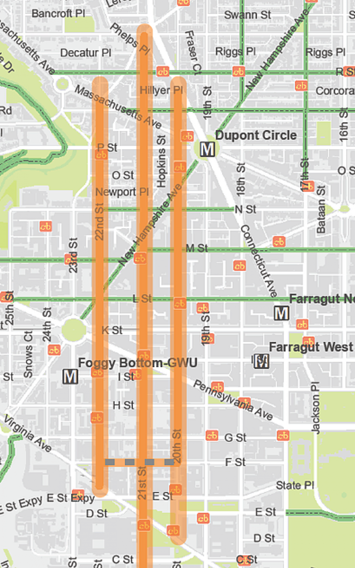
What’s happened so far
DDOT has been studying a protected bikeway on 21st Street as well as alternatives on 20th Street and 22nd Street. After holding preliminary public meetings on the project in early 2018, DDOT presented and received feedback on early designs for the project and asked for public comments.
After a December public meeting about the projects, a group of residents living along 21st Street began organizing against a protected bikeway on their blocks between New Hampshire Avenue and Florida Avenue, with concerns about losing a lane of residential parking and the ability to illegally stand and load on the block. Their advocacy came to a crescendo at the January 9 meeting of Advisory Neighborhood Commission 2B, where after nearly two hours of public comment including nasty anti-cyclist sentiment, the Commission was left without time to pass a resolution on the project.
After that meeting, DDOT extended the public comment period to February 13 and ANC 2B scheduled the February 5 special meeting to finish discussing the project.
Lanes for whomst?
MoveDC identified 21st Street to connect western Dupont Circle to the National Mall for several reasons. It’s long, connecting directly from near the intersection of Florida and Connecticut Avenues in the north to the National Mall in the south. It also connects well with current bike infrastructure—protected bike lanes on M and L Streets and painted lanes on Q and R Streets.
The end of the 21st Street lane is just two blocks from the start of bike lanes on Columbia Road, which connect to Adams Morgan. And in MoveDC, the 21st Street protected bikeway would connect directly to a protected bikeway on Massachusetts Avenue northwest to Ward 3.
The only issue with 21st Street is that it's a relatively narrow street, for this area. In addition to one travel lane there can be two lanes of parking, or a protected bikeway and one lane of parking, but not two lanes of parking and a protected bikeway. On 21st Street DDOT needs to make a decision—are 68 spaces of residential parking more important than cyclist infrastructure and safety?
By the agency’s own policies, like Vision Zero and MoveDC, the answer is no. Transportation experts including at DDOT talk about a “pyramid” of priorities for the roadway, with things like transit or walking at the top, deliveries also important, driving, etc. and usually private parking at the bottom. But that doesn’t mean resident activism won’t play a strong role.
Or are alternatives worthwhile?
DDOT and neighborhood leaders have been considering other potential options.
A protected bikeway on 22nd Street would connect from D Street to Massachusetts Avenue. Crucially, it would not connect to the Q and R streets bike lanes, nor connect to the National Mall.
A protected bikeway on 20th Street would also not go all the way to the National Mall. It would connect to the Q Street lane, but fall half a block south of the R Street lane. There’s one longer-term possibility for reaching R: a streetscape study on Connecticut Avenue between Dupont Circle and California Street. There is a possibility, though far from a certainty, that a protected bikeway on 20th Street could connect to one on Connecticut Avenue up to Columbia Road.
Another challenge with 20th Street is figuring out how to accommodate the Dupont Circle farmers’ market, which occupies 20th Street between Massachusetts and Connecticut avenues on Sundays.
There’s also a mix and match option which would pick 21st Street in Foggy Bottom, 20th Street in Dupont Circle, and connect to each other on a block somewhere south of New Hampshire Avenue. This mix and match option is what ANC 2A, in Foggy Bottom, has suggested in a resolution.
ANC 2A in Foggy Bottom suggested a "mix and match" approach to the protected bikeway. Image by Patrick Kennedy.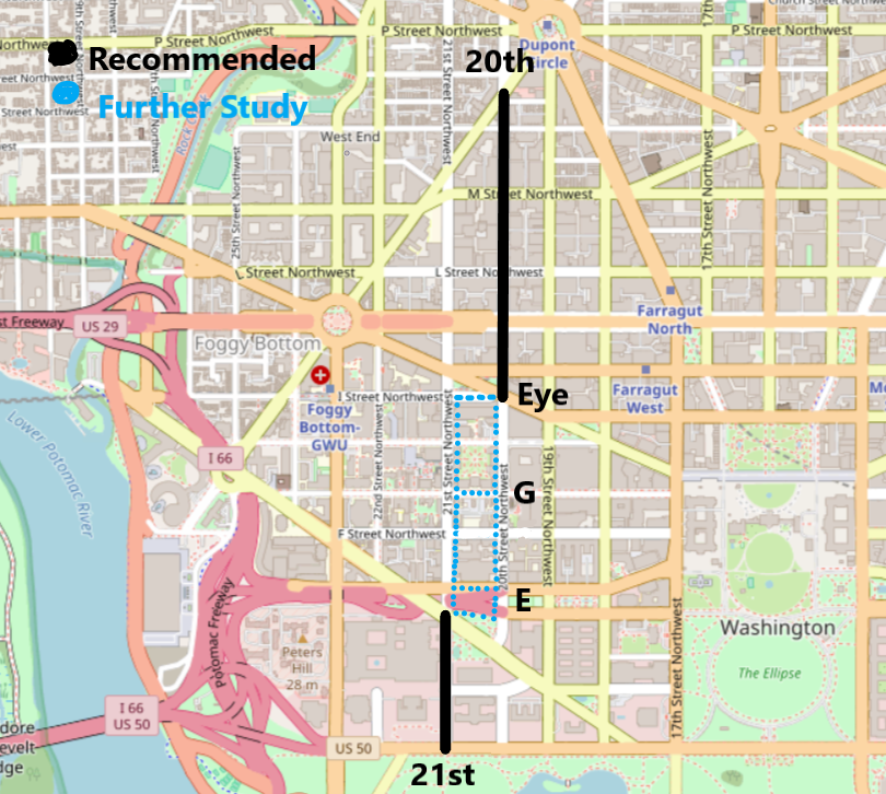
DDOT is hearing a lot about the challenges with building a protected bikeway. Will they hear from you too?
A protected bikeway on any of the streets is better than a protected bikeway on none of the streets. As with all allocations of public space, there are tradeoffs, and DDOT is hearing from a vocal group of people who do not want a protected bikeway in their front yards.
What do you think DDOT should do? Give your comments to DDOT using the form below, and if you can, show up on Tuesday, February 5 at 7 pm at the Johns Hopkins School of Advanced International Studies (SAIS), 1717 Massachusetts Avenue NW, Room 500.
Correction: A previous version of this article stated that the 2005 plan was MoveDC. It was actually the Bicycle Master Plan; MoveDC came out in 2014.