Here’s how much of the Washington region is off-limits to growth
_800_532_90.jpg)
The newly-adopted Minneapolis comprehensive plan eliminates exclusive detached single-family home zoning and allows for more density, including triplexes like this one in Chicago. Image by Eric Allix Rogers licensed under Creative Commons.
The US urbanist community has been profoundly shewk by Minneapolis moving last week to end single-family zoning citywide. It raises the question: How much of the Washington region is locked into the least-intensive level of land use via the type of zoning that Minneapolis will now end?
Brookings: Minneapolis 2040: The Most Wonderful Plan of the Year
New York Times: Minneapolis, Tackling Housing Crisis and Inequity, Votes to End Single-Family Zoning
CityLab: Why Minneapolis Just Made Zoning History
Slate: Minneapolis Confronts Its History of Housing Segregation
Strong Towns: Three Cheers for Minneapolis (The 3 is for Triplex)
And so on. It's not just hype—the newly-adopted Minneapolis comprehensive plan is a truly radical document by US planning standards. The change that has received the most national attention is the elimination of detached single-family zoning in the city.
Once the new plan is implemented, the capacity of these parcels will rise to triplexes (i.e. up to three attached units), subject to the same height and setback requirements present under the old zoning. As reported in the CityLab piece, 75% of the city's land area is zoned for detached single-family homes. This upzoning is therefore a potential dramatic pivot from a status quo of protecting most neighborhoods from any change, while concentrating it in some areas.
This is the current status quo in our region, as well. Payton Chung has written extensively about this here on GGWash, documenting how most growth in the District is forced into just a few areas, which has immediate implications for affordability and authenticity. This growth pressure is even more intense in this post-recession real estate cycle, where households and firms are showing a much stronger location preference for the urban core.
Over 60% of the new housing units built in our region between 2010 and 2017 were in DC, Arlington County, and the City of Alexandria, which cover only 7% of the region's land area. We are essentially requiring a microscopically small number of neighborhoods to accommodate the entire region's growth.
Data are from the US Census. Image by the author.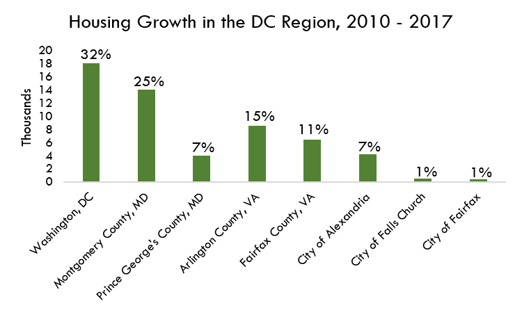
To get a better sense of what this looks like at the regional level, I mapped the zoning of each jurisdiction and separately calculated the percentage of their land area that is either preserved open space, agricultural reserve, or exclusively zoned for detached single-family homes. If a zone allows even just duplexes, I didn't count it. I was looking for areas that are essentially frozen in amber at the lowest densities, with no by-right option to increase land use intensity, even incrementally.
Data sources: DC; Montgomery County; Rockville, MD; Gaithersburg, MD; Prince George's County; Laurel, MD; Arlington County; Alexandria, VA; Fairfax County; Falls Church, VA. I privately obtained zoning data from the City of Fairfax, VA, and I digitized by hand the zoning maps of Laytonsville, MD and Poolesville, MD. The towns of Barnesville, MD and Brookeville, MD are missing from this map and this analysis. Image by the author.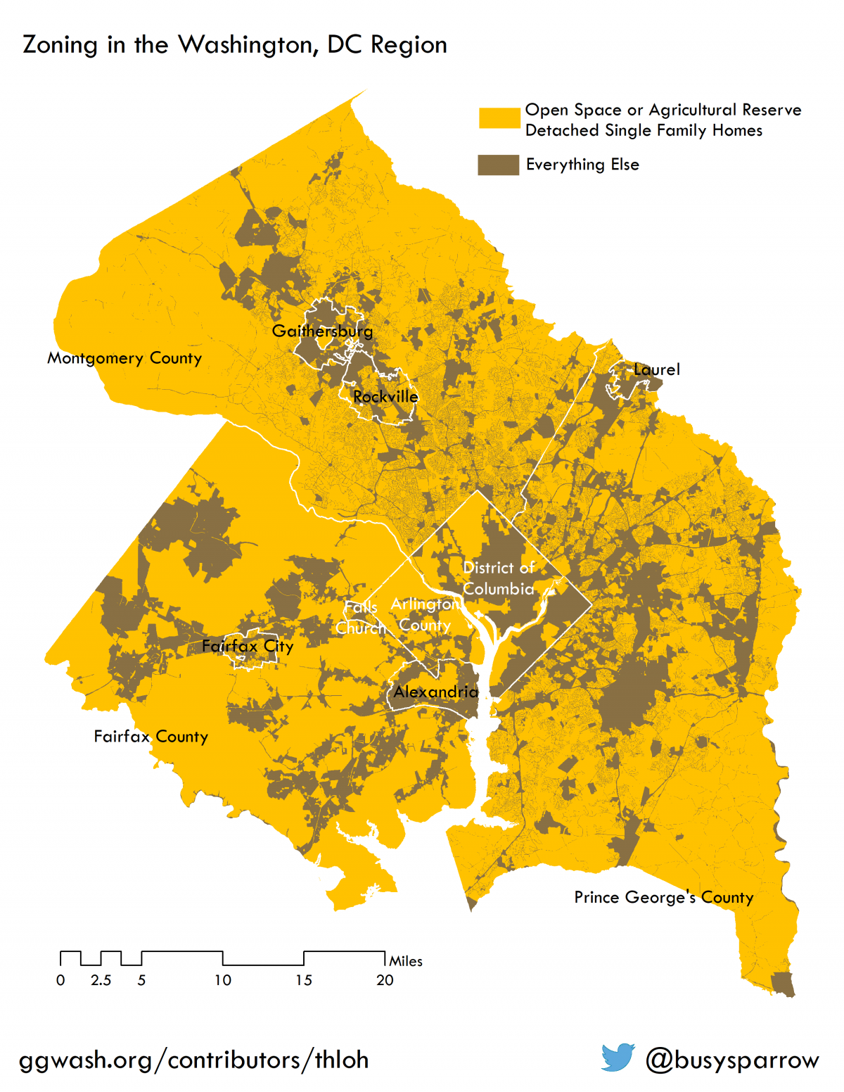
I summarize these findings in the table below. Our region is at a different point in its urbanization history than Minneapolis. While Minneapolis Public Radio noted that “even New York, Chicago, and Seattle only allow single-family homes in some areas,” DC's 42% single-family/open space zoning is nowhere near Minneapolis' 75%. Arlington's 75% is right on par, and as Edit Board member Sean Maiwald recently wrote, the single-family zones within that tally could represent an opportunity to house Amazon's incoming workforce if upzoned incrementally.
Municipalities with local zoning control are tabulated separately. In other words, for example, area within Gaithersburg is not counted as part of Montgomery County. Several smaller municpalities in Montgomery County have been excluded from this tally for convenience. Image by the author.
While DC's jurisdictional figure beat the old Minneapolis, when we zoom in to the urban core we can see that inequality is structurally baked right into these geographies through zoning.
Image by the author.
Image by the author.
Over half of Northwest DC, the city's largest quadrant, is “protected” at the lowest level of residential density or is undevelopable, including areas within easy walking distance of Metrorail, while neighborhoods like Southwest get what Strong Towns calls the “fire hose.”
DC and Arlington both recently adopted updated accessory dwelling unit provisions that may help these neighborhoods welcome some more neighbors. However, there is clearly more that could be done to address structural inequalities between neighborhoods in the urban core.
This zoning maps and tables have been updated for clarity.