The tragic death of a cyclist highlights the danger of this Capital Crescent Trail crossing

This is the intersection of Little Falls Parkway and the Capital Crossing Trail where Dr. Ned Gaylin was killed by a driver while cycling. The county added more flexposts and mini-stop signs after the incident. Image created with Google Maps.
My neighbor, beloved longtime Chevy Chase West resident Dr. Ned Gaylin, was killed by a driver while cycling at the nearby intersection of the Capital Crescent Trail and Little Falls Parkway in October 2016. In reaction to this tragedy, Montgomery County and the local parks service are considering some engineering changes to protect people walking and biking in the area.
While there may have been issues of inattention or negligence contributing to this incident, the underlying engineering was likely a contributor. At the time there were two vehicle lanes each way on Little Falls Parkway, and a driver struck Gaylin as he proceeded through the intersection, killing him.
This incident is sadly not uncommon. The county and the greater Washington region still struggle to address safety issues in White Flint, Alexandria, Capitol Hill, and beyond.
Design of Little Falls Parkway in December, 2015 prior to Dr. Gaylin’s death. Image created with Google Maps. 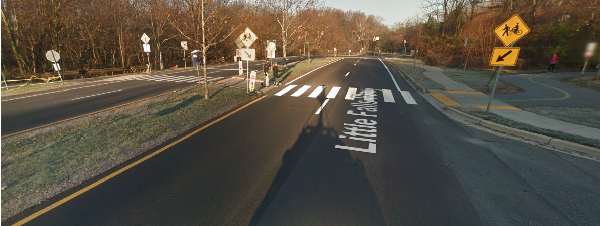
Montgomery County is trying to improve safety for people walking and biking
Montgomery County is one of the first counties in the nation to endorse a Vision Zero initiative to eliminate severe and fatal collisions by 2030, and it’s currently developing a county-wide Bicycle Master Plan.
Vision Zero is a safety project that originated in Sweden in the 1990s and has since been adopted by jurisdictions around the world. It aims to create road systems with no fatalities or serious injuries involving traffic. One of the core principles of Vision Zero: “Human life takes priority over mobility and other objectives of the road system.”
After Gaylin’s death, the Maryland National Capital Park and Planning Commission (M-NCPPC) Parks Service implemented a temporary road diet at this intersection by decreasing the vehicle lanes from two to one each way, reducing the speed limit to 25 mph, and adding more signs.
So far, it seems to be working. According to M-NCPPC Parks, “driver behavior has successfully adjusted to the interim conditions and accidents at the crossing have been dramatically reduced.”
Current temporary road diet at the intersection. Center lanes are travel lanes while outer lanes are blocked by temporary flexible bollards. Image created with Google Maps. 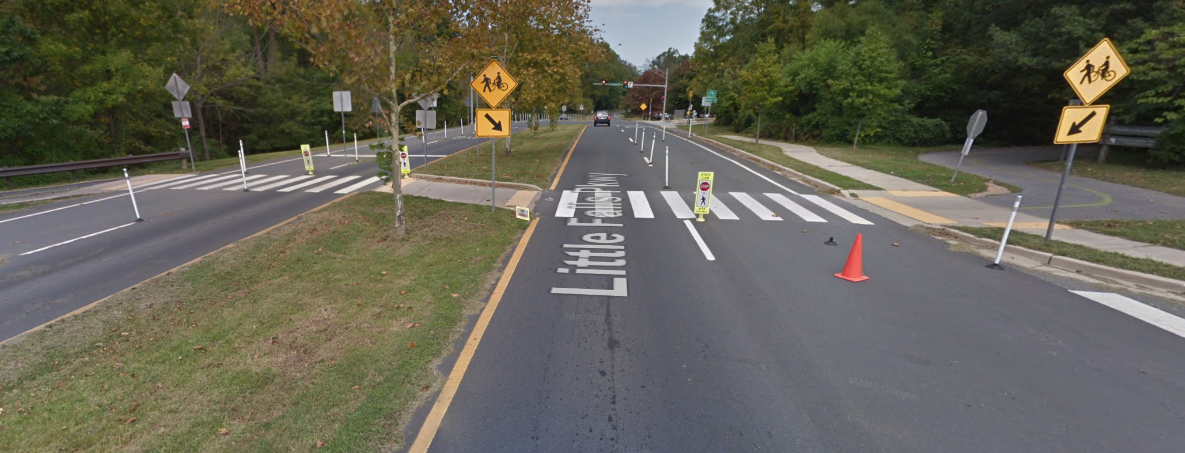
Montgomery County called multiple-lane trail crossings such as this one “high risk” in their Vision Zero Two Year Action Plan and said such multi-lane intersections should be “transformed first” with “safety as a priority.”
The Action Plan highlighted the specific infrastructural design change made at this intersection as an example of “Improving Dangerous Intersections” [page 20]. Image from the Montgomery County Vision Zero Two Year. 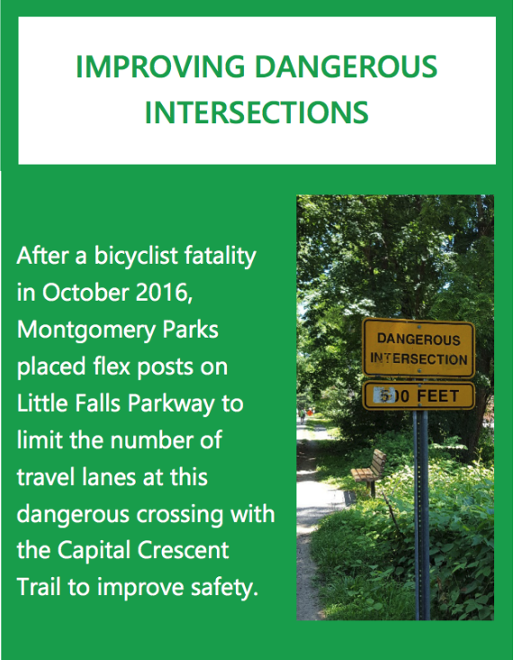
Now, M-NCPPC Parks is considering permanent options for this intersection and has retained Sabra Wang & Associates to help review design records, traffic counts, crash data, and field surveys to support preliminary recommendations. A meeting was held at nearby Somerset Elementary School on June 13 to review a broad range of proposals and statistics.
Here’s what the county could do to protect people biking and walking
The options being considered are wide-ranging and can be reviewed in detail on the project plan website. Common overarching elements include improved lighting and potentially closing the third entrance to the Bethesda Pool on Little Falls Parkway nearest the trail. The Montgomery County Department of Transportation (MCDOT) is exploring additional traffic calming measures on Hillandale and Arlington roads.
Beyond that, the design alternatives for the intersection itself can generally be categorized into three approaches:
- Continue or even increase the road diet at the intersection or beyond (Alts 4,5,8,9,11,12). This would include options where Little Falls Parkways would be one lane each way similar to the current temporary implementation, options where the road diet is continued as far as Dorset Ave, and even an option where Little Falls Parkway is closed entirely between Hillandale and Arlington Roads. Varying methods of trail and traffic control could be utilized including a speed table and raised trail crossing and either an activated on-demand trail crossing signal or stop signs similar to the existing design.
- Return to two lanes each way with various options for trail and traffic control including rerouting the trail to the intersections of either Hillandale or Arlington Roads, introducing a third traditional traffic signal at the trail crossing, and possibly utilizing on-demand lane alternation from two to four during peak hours (Alts 1,2,3,10).
- Build completely separated infrastructure such as a trail bridge or tunnel (Alts 6,7).
At the meeting, attendees raised a number of concerns about trail safety, traffic delays at the intersection, anticipated growth in the Bethesda area, and diversion of traffic into adjacent neighborhoods such as Hillandale, Arlington Roads, and Kenwood.
Nonetheless, at the meeting M-NCPPC Parks representatives said the data shows that the current temporary road diet has dramatically improved safety for all users — trail and road — while minimally impacting vehicle traffic. Even small traffic delays that could result are countered by large volumes of pedestrian and bicycle traffic that flow along this popular trail year-round, including vulnerable children and elderly citizens.
If we want to get serious about keeping people safe, we need a road diet
The easiest and and most cost-effective way to continue the improved conditions at this intersection would be, as in category 1 above, to introduce a permanent road diet consisting of one lane each way. Or we should close Little Falls Parkway entirely at this crossing.
Measures would have to be taken to ensure that vehicle traffic is not inappropriately diverted into area neighborhoods. Traffic calming steps are already being planned for both Hillandale and Arlington Roads and could be taken for Kenwood and other adjacent neighborhoods. Parks data has shown that motor vehicle traffic is minimally impacted by similar temporary design, while safety is dramatically improved.
It would be very disappointing if M-NCPPC and the county decided that Little Falls Parkway should be reopened to four lanes of traffic. If they keep the four lanes, then we must find funding to build separated infrastructure, such as a trail bridge or tunnel (as in Alternatives 6 or 7 on the project website).
This would be expensive, but any alternative variation of a four-lane at-grade crossing, regardless of exact location or signaling, will be building infrastructure that will lay the foundation for another major injury or death. The Vision Zero action plan identifies multi-lane crossings as high risk, regardless of whether there are stop signs or not.
In addition to the common safety elements above, the plan also emphasizes maintaining connections to area trail networks, including the previously explored but yet to be implemented Capital Crescent Trail Connector Plan. To date, Option D would consist of a hard surface trail to connect Little Falls Trail to the Capital Crescent Trail along Hillandale Road and Little Falls Parkway.
Option A to connect Little Falls Trail and the Capital Crescent Trail may be reconsidered if a bridge or tunnel is built across Little Falls Parkways. Image from M-NCPPC. 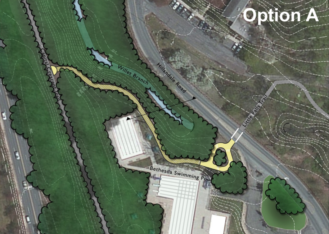
Several Crossing Plan alternatives appeared to revive Option A, which would be a more direct connector from the Little Falls Trail behind the Bethesda Pool to the Capital Crescent Trail. It would maintain continuity if a bridge or tunnel is chosen as a permanent solution. Both options should be reconsidered, depending on the permanent solution chosen for the intersection.
The currently approved Option D for an improved connection between Little Falls Trail and the Capital Crescent Trail, including the intersection being considered as part of this project. Image from M-NCPPC. 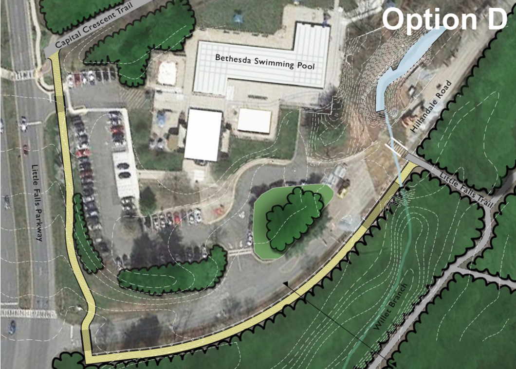
Here’s what’s happening next
Over the summer and fall of 2018, M-NCPPC Parks plans to collect public feedback and narrow down the broad range of proposals to three preliminary designs, which will be presented at a second community meeting. They will then continue to solicit feedback and narrow those three to a solution that will be presented to the M-NCPPC Planning Board this winter.
Montgomery County and M-NCPPC Parks have endorsed the Vision Zero Initiative. In that spirit, they have implemented successful infrastructural change and collected data proving that it causes minimal inconvenience while dramatically improving safety for all users of the Capital Crescent Trail and Little Falls Parkway. There is no justification to go back to any permutation of the previous dangerous four-lane design.
The project website has full details, including alternatives and plans, and will be accepting feedback through the summer and into the fall. If you care about the future of Vision Zero and the safety of trail and road users, you can provide commentary and continue to monitor the status of this plan.
Correction: This article previously stated that a driver in one lane yielded to Gaylin to let him cross, and a driver in the adjacent lane struck him. Montgomery County police say there was only one driver.
GGWash sometimes organizes around issues affecting our region. Should we consider advocacy around this topic? Let us know!