How should the region’s transit grow?

Photo by alykat on Flickr.
How should the Washington region grow its transit system to benefit users across the region? Will the streetcar and rapid bus projects create into a disjointed patchwork or will they mesh well across jurisdictional borders? How can Metrorail avoid running out of capacity by 2040?
These are some questions regional officials ought to be discussing, but mainly aren’t. The Transportation Planning Board, which is supposed to plan regionally for transportation, instead acts as a “stapler” to simply assemble the different states’ transportation projects into a formal, constrained plan as required by law.
Individual jurisdictions have some great surface bus and rail projects, from DC’s and Arlington’s streetcars to the Purple Line and a number of BRT proposals, but so far these don’t cross jurisdictional borders. It’s important to analyze how they could all fit together to meet regionwide transportation needs.
WMATA is the region’s regional transportation body and runs services in all jurisdictions, but the Metrorail system is running out of capacity. Even if Metro can get the money to upgrade power systems and add railcars to make all trains 8 cars, the system is likely to pass its maximum limits before 2040, in some areas possibly much sooner.
Trains on the Orange Line from Arlington are crush loaded today, and the “Orange and Blue Line Service Increase” plan will relieve the bottleneck, but soon create a new one for Yellow and Green Line trains merging at L’Enfant Plaza. There will be more Yellow Line trains coming in from Virginia, and meanwhile growth at the Capitol Riverfront and hopefully east of the river and in Prince George’s County will increase demand for more Green Line frequencies.
To try to answer these questions, WMATA has begun a study of regional transit mobility. That includes how the many projects around the region fit together or could fit together, and how Metrorail can meet its capacity needs.
For the Metrorail portion, planners are looking at a number of options including a new tunnel for the Yellow Line from the Potomac River to downtown DC. It could travel up 9th Street, as we reported last year, or head east past Waterfront and turn north to meet the Red Line at either Judiciary Square or Union Station.

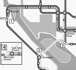
Left: Possible separated Yellow Line tunnels. Right: Possible track and pedestrian connections. Images from WMATA.
The long-discussed pedestrian connections between Farragut North and West and between Metro Center and Gallery Place will be on there. The study will also look at new track connections between Orange and Blue near Rosslyn, Blue and Yellow near Pentagon, and Yellow and Green south of L’Enfant.
Combined with a new Yellow Line tunnel, this could allow different service patterns, such as this one as an example. (Note that GGW readers came up with this; WMATA has not yet proposed or evaluated this or any other service pattern in published documents to date.)

Potential service pattern suggested by GGW readers.
At the same time, parking demand will increase in many car-dependent areas, creating a demand for up to 40,000 more spaces. However, it’s very expensive to build those spaces. Many of the riders who park at stations are or will be coming from less than 3 miles away. Therefore, Metro can probably best expand the ability for residents to access its stations by improving pedestrian and bicycle accessibility. The study is also looking at the possibility of creating park-and-ride centers away from Metro stations and running feeder buses to the rail system.
Besides looking at Metrorail, the study will look at how jurisdictions’ individual bus and rail projects can and will meet regional transportation needs. Should DC’s streetcars connect to Maryland or across the Potomac? Should the Purple Line eventually continue its circle around to the south and to Alexandria? And what about the often-suggested Metrorail extensions to Centreville, Gaithersburg, BWI, Bowie, Waldorf and Dale City?
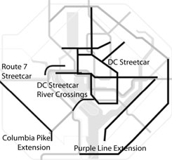
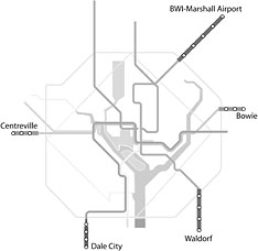
Left: Possible extensions of surface rail and bus projects. Right: Possible Metrorail extensions. Images from WMATA.
Growth trends in the region will require new transit solutions. Commuting between suburbs is expected to grow by 45% in the next 30 years, while commuting to the core will keep growing as well, by 12%. It’ll be interesting to see what WMATA planners come up with, and it’s great to see them trying to answer these fundamental and absolutely vital questions. Someone has to do it.