Maryland’s systemic streets
Last year, I mapped Washington’s street-naming system and state-named avenues. But the logical organization of street names doesn’t end at the DC line. The alphabetical and numerical naming of streets continues into Maryland (and Arlington).
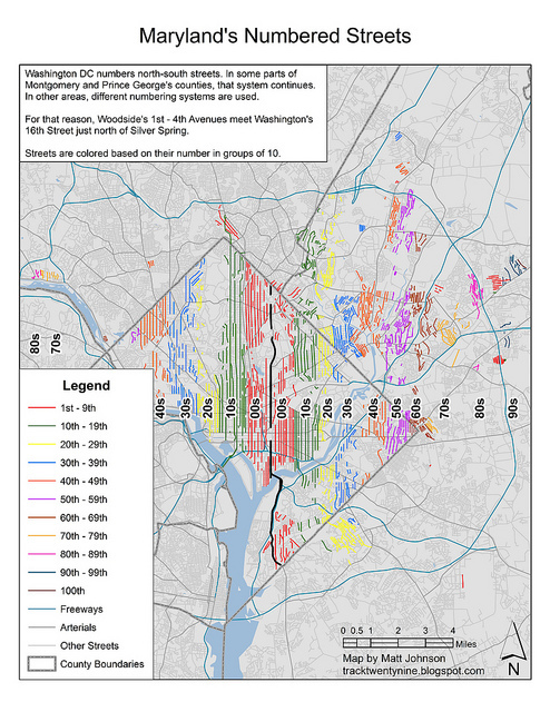
Washington’s numbered streets run north-south and increase in number as distance from the Capitol increases. The highest numbered street in the District is 63rd Street, near Capitol Heights. But the numbers continue to increase well into Prince George’s. The numbering system eventually gives up the ghost a few blocks from the Seabrook MARC station, where one can find Lanham’s 100th Avenue.
Note: this is a revised version of the original.
Several communities have independent street numbering. Just north of Silver Spring, Woodside’s low numbered avenues intersect DC’s 16th Street. Glenarden and Lanham also stand apart with their non-DC-based numbered streets.
In the District, east-west streets are given non-numeric names. In most cases, streets increase alphabetically with increasing distance from the Capitol. This system is repeated in certain parts of both Montgomery and Prince George’s counties. The alphabetical march of streets stretches from Oxon Hill to Beltsville, admittedly with quite a few gaps.
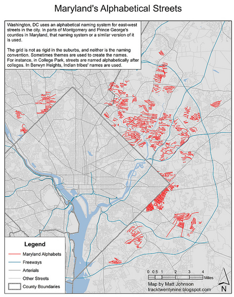
With nothing more than an arbitrary political boundary dividing Maryland from the District, the street grid continues across the DC line unabated in many places. As a result, places like Chevy Chase and Mount Rainier see direct continuations of DC’s “alphabets”. So the pattern of the alphabetical progression is easy to pick out.
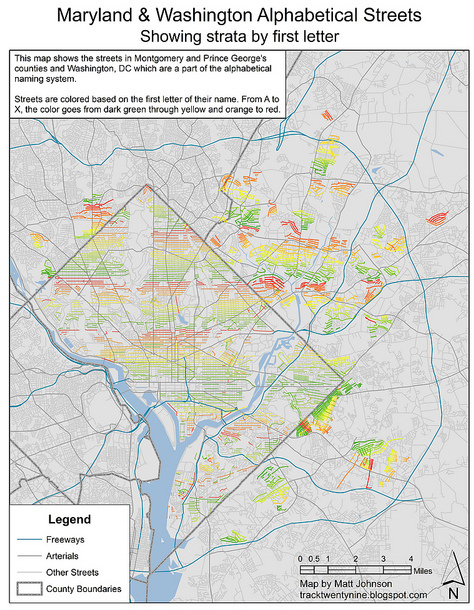
In Hyattsville and the neighboring communities, many of the street names are very similar to those found in DC, with the same progression of names in many cases. In both Hyattsville and Northwest DC, Hamilton is followed by Ingraham, Jefferson, Kennedy, and Longfellow.
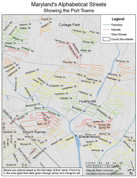
But other neighborhoods have unique progressions. In College Park, universities lend their names — in alphabetical order — to streets. Further north, the streets of Berwyn Heights and Langley Park use Indian names. A trip up Rhode Island Avenue reveals names like Apache, Blackfoot, Cherokee, Delaware, and Erie.
Yet, unique names aren’t the only uniqueness in street naming. Capitol Heights hugs the District line. There, streets parallel to Southern Avenue increase alphabetically as distance from DC increases. But the perpendicular streets also use an alphabetical system, increasing with distance from East Capitol Street.

However, the alphabetical and numerical streets aren’t the only thing that Washington bequeathed to her suburbs. Several of the state-named avenues continue into Maryland as well. Georgia Avenue in Montgomery and Pennsylvania Avenue in Prince George’s stretch the farthest. Both roadways keep their names all the way to the Patuxent River.
Wisconsin, New Hampshire, and Connecticut are all major arteries to the suburbs. Massachusetts and Rhode Island are also important links across the border. Rhode Island is discontinuous and skips around across northern Prince George’s, following an old streetcar route.
Rounding out the bunch are Nevada and Kansas. Chevy Chase, Maryland is home to 2 short blocks of Nevada Avenue. And Kansas Avenue changes its name to Kansas Lane when it crosses Eastern Avenue in Takoma Park.

Author’s note: The original version of this article included a map showing the numbered streets which inadvertently left out the numbered streets in Cabin John, Maryland. A revised map has now been inserted. The original can be viewed here.