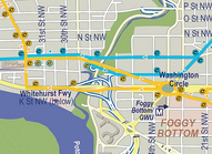
Why is the Circulator now one way on K Street?
Communications problems aside, a number of residents aren’t sure they’re so happy about DDOT rerouting the Georgetown-Union station route to run west on lower K Street while keeping the eastbound route on M Street.
First and foremost, why run on K Street at all?
Aaron Overman, Deputy Director for Progressive Transportation Services, confirmed that DDOT wanted to reduce the bus density in a corridor that is already served by more than half a dozen Metrobus, Circulator, private shuttle and tourist bus routes.
Moreover, lower K Street has a number of attractions, including the the NPS boathouse, the House of Sweden, Washington Harbour, the movie theater, and the waterfront park. All of which are currently poorly served by transit. Overman said, “Without changes, M Street was overserved [and] this was an opportunity to more evenly distribute service.”
Some commenters also wondered if the change would save any time, considering congestion at 25th Street and the Whitehurst on-ramp. Overman said,
We tested travel times at different times of day and night and found that the Circulator reached the first stops on Wisconsin Avenue sooner in ALL cases by traveling on lower K versus getting stuck at traffic lights and congestion on M Street westbound. It is a travel time savings for customers heading up Wisconsin and also makes the entire line run smoother by reducing the end-to-end travel times so buses can continue back toward Union Station more quickly.
Why not run on lower K Street in both directions?
If M Street is overserved by all those bus routes running westbound, isn’t it overserved in the eastbound direction as well? If serving K Street was intended in part to give employees at Washington Harbour easier transit access to their jobs, why make them walk up the 29th Street hill to catch the bus home?
Furthermore, running one-way routes on separate two-way streets is anything but user friendly. When unfamiliar riders get off a bus on a one-way street, they have an expectation that the return trip will start on a different street. If you get off a bus on a two-way street, on the other hand, most people will expect to board a return bus on the opposite side of the street within one or two blocks.
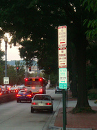
This will be particularly problematic because Circulator stop flags don’t indicate routes and many stops don’t have the spinning system maps. Even those that do may not get updated maps for some time.
The only direct answer I got from Overman was this:
The K Street routing was at the request of people/businesses on K Street who had service prior to 2008. The inbound K-outbound M service pattern was in effect since the Circulator began service and was only changed when we began to go up Wisconsin Avenue. People can always transfer at Wisconsin and M if they don’t want to walk.
Based on this answer, it seems DDOT has fallen prey to the intractable “the way we’ve always done it” mistake. Circumstances have changed drastically since the Circulator last ran this route. At that time there was no other Circulator service on M Street. Now it is served in both directions by the the Rosslyn-Dupont route.
Why is there no stop on K Street west of Washington Circle?
No stops on K Street.
Before last weekend, you could catch a Georgetown-bound Circulator at the Northeast corner of Penn and 24th St, or at the triangle park at Penn, 25th and L. With the new changes, the nearest stop in Foggy Bottom/West End is at Penn and 22nd Street. Then the bus shuts its doors and travels 8 blocks to 30th and K before it makes another stop.
There was no need for the Circulator to stop at both 24th and 25th Streets. One of the biggest advantages the Circulator offers over Metrobus is that it stops less frequently, cutting travel times. Still, the new distance between the last stop in Foggy Bottom and the first in Georgetown is now longer than the distance between many downtown Metro stops. But while cutting stops, DDOT should have taken the opportunity to eliminate 21st and Penn while keeping 22nd and Penn.
DDOT officials said that because of the traffic patterns, current parking spaces, and curb cuts it is impossible to have a bus stop on K Street west of Washington Circle. Traffic flow prevents the bus from stopping at the island between the circle and 24th Street. On the other side of 24th street, bus stops require 100 feet of “clear zone,” so even if the parallel parking space on the K Street service road were removed, driveways break up the the curb every 50 feet or so. Street trees and shrubs also cause problems because of ADA accessibility guidelines.
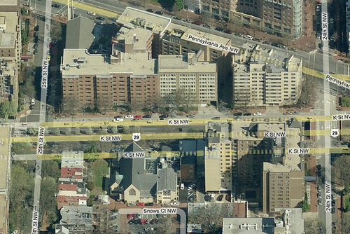
Where can we put a stop?
There is, however, about 100 feet of curb along K Street just east of 25th street. It’s unclear if the parking spaces on this section were removed whether a bus stop could be placed there, though, because about half of that curb is technically in the intersection. Overman said,
The only way to accomplish an accessible, safe stop is to eliminate most if not all of the parking along this section of roadway. If the community and ANC tell us they would rather have a bus stop than parking, DDOT is happy to accomplish this.
I’m unsure why a 100 foot bus stop would require removing most or all parking on a 400 foot block, and not just the 4 spaces nearest the 25th Street intersection. Still, removing any spaces certainly can pose a political problem. If you are a Foggy Bottom or West End resident, contact DDOT and ANC 2A to let them know that you support a new stop along K Street.