The non-circles of Washington: Part 2
Yesterday, I discussed the former circles of Washington. Today, let’s take a look at the circles that never were.
There have been many proposals, some more serious than others, for unbuilt circles in DC. As the District changed from open countryside to city, plans were made to add circles in a variety of locations. Let’s take a look at a few of these almost-circles.
Hamilton Circle, seen below in the 1921 edition of the Baist’s real estate atlas of surveys of Washington, District of Columbia, was proposed at the corner of Massachusetts Avenue and Idaho Avenue NW. Though it was never built, it can still be seen in the property lines at this intersection.
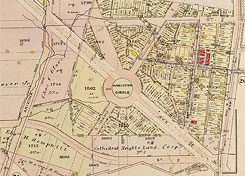
Hamilton Circle (left) and “Idaho Circle” (right).
Idaho Avenue was to continue to where Tilden Street and Reno Road NW meet today near the University of the District of Columbia, and there was a circle planned for the intersection. While this circle never came to pass, I’m labeling it Idaho Circle for the purposes of this discussion.
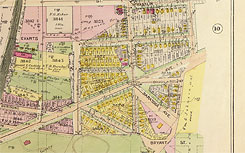
Near American University, Massachusetts Avenue passes through Wesley Circle, which was never fully built out and looks more like a collection of slip lanes than it does a circle. One interesting feature is the drive-through mailbox on the south side of the “circle”. If you click here, you can still see the circle represented in some of the existing property lines.
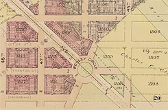
Wesley Circle (left) and McKinley Circle (right).
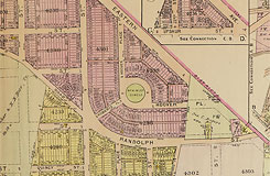
McKinley Circle was part of a proposed development in what is now the Woodridge neighborhood. Today, it’s the location of Barnard Hill Park.
Dahlgren Circle would have been located at the corner of Rhode Island Avenue and 12th Street NE. If you look here, you can still see it represented by the property lines on the eastern side of the intersection.
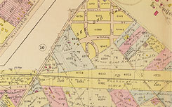
Dahlgren Circle (left) and “Adams Circle” (right).
While it wasn’t planned as a true circle, the combination of Adams, 30th, and W Streets NE would have created a near-perfect circle. I’m calling this one Adams Circle. Looking here, you can see that the yellow area on the map above was the only residential area around the circle to actually be constructed, while the rest ultimately became industrial land. In the end, the extreme topography here (the residential land is at a much higher elevation than the industrial land) precluded the circle ever truly being built.
Let’s wrap up the proposed circles with some that were never built in areas just north of old Boundary Street.
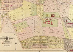
Columbia Heights Circles (from DC Vote.)
Open up the map on the right, and you’ll see it shows a proposed street grid that was not fully implemented in the area just north of the L’Enfant city. Note that today’s Logan Circle was still known as Iowa Circle. What is now Sheridan Circle was labeled Logan Circle.
There was a Meade Circle proposed at what is now the intersection of 16th Street, Columbia Road, and Mt. Pleasant Street. Grant Circle (which is now in Petworth) is shown where 12th Street, Columbia Road, and New Jersey and California Avenues all cross. Speaking of New Jersey Avenue, where it crosses an extended Vermont Avenue, there is a McClellan Circle. Finally, where U Street, North Capitol Street, and Rhode Island Avenue cross there is a Sedgwick Circle. All of these circles would have been named after Civil War Generals. I’ve linked to information about each of them.
Also worth noting are a few circles and partial-circles along the city’s edge:
Wisconsin Circle is a quarter-circle at the intersection of Wisconsin Avenue and Western Avenue, just over the line in Maryland.

Pinehurst Circle
Pinehurst Circle is located in the Chevy Chase neighborhood of DC at the intersection of 33rd Street, Worthington Street, Utah Avenue, and Western Avenue. Recall that at the District’s boundaries, Eastern, Western, and Southern Avenues and all of their sidewalks and curb cuts lie entirely within DC.
The District side of Pinehurst Circle is a well-formed semi-circle with the roadway and curbs built to typical city standards. On the Maryland side, the property lines of the houses line up to form a circle, but the roadway was never built. They are accessible by a patchwork of driveways leading from Western Avenue and branching off to the different houses. The placement of one of DC’s original 1792 boundary stones in the uncompleted section adds to the geometric intrigue of this half-formed circle.
Portal Circle? Blair Circle? The circle on Eastern Avenue where it meets North Portal Drive, 16th Street, and Colesville Road doesn’t appear to have a name, but it’s passed through by thousands each and every day entering and leaving DC.
Last, but certainly not least, my favorite partial circle, Carson Circle. This one-third of a circle is located where Michigan Avenue turns into Queens Chapel Road at Eastern Avenue, and it even has a bank in the middle of it. A more proper shrine in today’s United States than the statues of generals that grace so many other circles?
Do you know about another proposed circle? Share it with us in the comments.