Exodus: Why DC’s Jewish community left the center city, then came back
Beginning in the 1950s, synagogues and other Jewish institutions left DC’s central commercial corridors for Upper Northwest and Maryland, and they didn’t return until the late 1990s.

Photo by Matthew Dailey on Flickr.
Washington’s Jewish community was relatively small in 1920s, standing at less than 15,000 members. Today, it’s got over 200,000.
This interactive chart depicts the Jewish community’s proximity to the US Capitol over time:
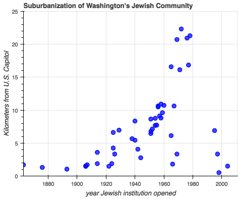
Graph by the author. Click for an interactive version.
Before World War II, Jewish residents, like their African American counterparts, faced housing discrimination through racially-restricted covenants that excluded Jews from being allowed to live in some DC neighborhoods, mostly in Rock Creek Park, along with some areas of Montgomery County including parts of Chevy Chase.
Also, Jews were not welcome at institutions like country clubs, leading the area’s Jewish community to create its own clubs. Notably, the Indian Spring Country Club moved from Petworth to Silver Spring and eventually to Layhill, mirroring the path of neighborhoods where Jews were able to live.
In the 1940s, the legal foundations of restrictive covenants were weakened, meaning the city’s African Americans were no longer boxed into subneighborhoods and the city’s Jews had greater freedom to move into Maryland. Also, DC suffered a severe housing shortage during the war, with the capital’s population booming while construction material and manpower were diverted to the war effort.
These factors led to DC’s white population falling precipitously after the war, with whites taking new federal highways to newly-built outlying areas and buying first homes with GI Bill loans that, for them, were easy to come by.
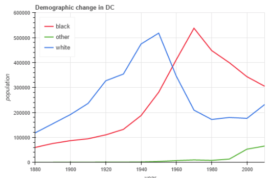
Image by the author.
In the 1950s, greater Washington was the sixth largest Jewish community in the United States, with 81,000 people (today it’s ranked fifth in the US). Half of that population already lived outside the city, mostly in Montgomery County, which you can see here:
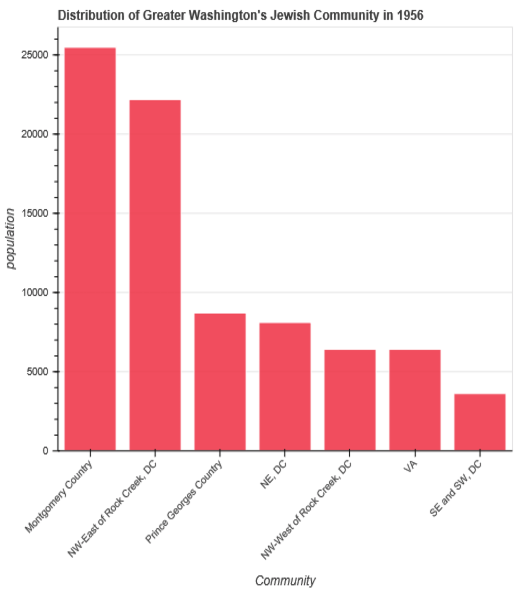
Graph by the author.
A 1956 survey captured DC’s remaining Jewish community in the midst of the change, two years after the District’s schools desegregated. The survey found large percentages of Jewish families planned to move within six-months, mostly to Montgomery County and neighborhoods in the northwest part of the city, west of Rock Creek Park: 21% of families planned to leave the northeast quadrant; 25% planned to leave neighborhoods in the southeast and southwest quadrants.
Even in many neighborhoods in the part of DC’s northwest quadrant that’s east of Rock Creek Park, the bastion of Jewish DC, 16% planned to move. Beginning in the 1950s, the Jewish community also had more options in the outlying areas. Among the most appealing destinations were new subdivisions built by Jewish real estate developers in areas of Montgomery County like Silver Spring. Kemp Mill attracted an Orthodox Jewish community. Langley Park in Prince George’s County become predominantly Jewish in the 1950s.
The map below is of Jewish landmarks in DC and Maryland during the mid 20th century compiled by the Jewish Historical Society of Greater Washington. If you click to the interactive version and then click the link with each icon, you can view photos. The collection also features pictures from the archive of Giant supermarket, run by a local Jewish family until 1998. That map makes clear that, while DC had many serious social problems in the 1940s, widespread “food deserts” were not among them.
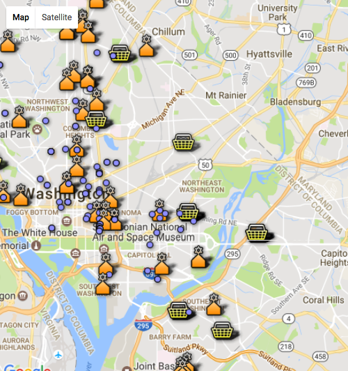
Click for the interactive version.