Thundersnow traffic illustrates east-west divide
As thundersnow passed through the DC area right at rush hour, we were able to see the nadir of bad traffic via Google Maps.
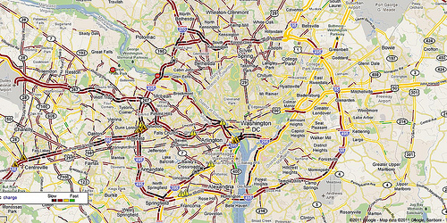
The map is color-coded based on speed: green for fast, yellow for slow, red for very slow. The red-and-black striped areas are probably where car traffic has stopped entirely. You can see that auto traffic in the DC area affects both suburbs and city equally, even if those who don’t have to drive can avoid it. But most importantly, you can see how normal, everyday highway chokepoints — like the Beltway/I-270 merge — have converged with other chokepoints, forming miles-long traffic jams, like the one along the Beltway from College Park to Springfield.
But the Beltway commute isn’t terrible for everyone. Notice how the most of the Beltway’s eastern half, going through Prince George’s County, is yellow. If you’re driving from, say, Largo to Greenbelt, your trip is probably a little slower than usual, but still fine.
There aren’t too many people in that situation, as most of the region’s jobs are located on the west side, in places like Bethesda and Tysons Corner. One of the reasons why traffic was so bad last night, and relatively bad every other night, is because every morning thousands of people have to travel from one side of the region to the other.
Commuters are then faced with a choice: pay more to live near your job, whether it’s in DC, Tysons or elsewhere, or spend less money on a home farther away from your job. That doesn’t always mean moving to a more distant suburb. For many, the most affordable housing choice, and often the only affordable housing choice, is in Prince George’s County, right on the District line.
There are lots of ways to fix this problem, like providing more housing in places like Tysons Corner where people already work, or putting more jobs in places like Prince George’s County where people already live.
These solutions won’t help anyone in traffic last night, but if implemented, they’ll make future rush hours more bearable for people on both sides of the Beltway.