New bike and bus lanes could soon carry you from Columbia Heights to Brookland
Right now, getting between Columbia Heights and Brookland is tough. Walking is uninviting, riding a bike is dangerous, and there aren’t many bus options. Even driving is a pain. The District Department of Transportation has a plan for making travel between these two places easier and safer.
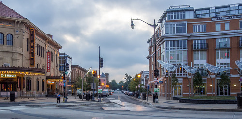
Looking east from Columbia Heights. Photo by ctj71081on Flickr
DDOT wrapped up its Crosstown Mutimodal Transportation Study with a final report last month. The study looked at possibilities for new street designs as well as bike and bus lanes in the area defined by Kenyon and Harvard Streets NW between 16th and Park Place; Irving Street and Michigan Avenue NW around the Washington Hospital Center; and Michigan Avenue from the hospital center to South Dakota Avenue NE.
There are major developments planned around the hospital in the next few decades. McMillan Sand Filtration Site will be a new center for housing and retail. Also, the Old Soldier’s home will eventually be redeveloped.
Right now, the major streets connecting the two areas, Irving Street and Michigan Avenue, are designed pretty much exclusively for cars, but they’re still plagued by congestion on either side of the hospital center. The H2 and H4 buses that run from the Columbia Heights Metro to the hospital and on to Brookland often get caught in traffic and take more time than they should to actually move through the hospital campus. And for people on bike or on foot, the corridor can be dangerous and unwelcoming.
The study to improve the corridor kicked off in February, and after presenting the public with options at a series of planned community meetings, DDOT narrowed down its plan to three possibilities by April, then two by June, then the final one in September. DDOT presented its draft concept in late September, and on October 19th issued the final report for a plan that will be unrolled onto city streets.
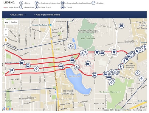
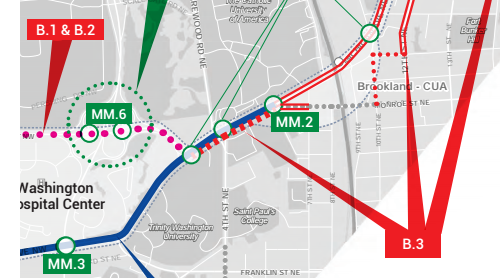
Early this year, DDOT asked residents to identify problem spots in this corridor. Maps and images by DDOT unless otherwise noted. Click for an interactive version.
Riding a bike will be way easier
DDOT’s plan puts a big focus on making it easier and safer to bike through the area by building a number of bike lanes.
Kenyon Street NW will get a two-way protected bikeway from 14th Street NW to where it turns into Irving Street at the hospital. From there, Irving Street will be converted to have a two-way center-running bikeway. A few more measures, like a possible signal at Kenyon Street and Irving Street, will maximize safety and guide the flow of people walking or biking along Irving Street. The first stage of the plan will establish two-way bike lanes, but the ultimate goal is to create a shared use pathway for bikes and pedestrians along Irving Street at the hospital center.
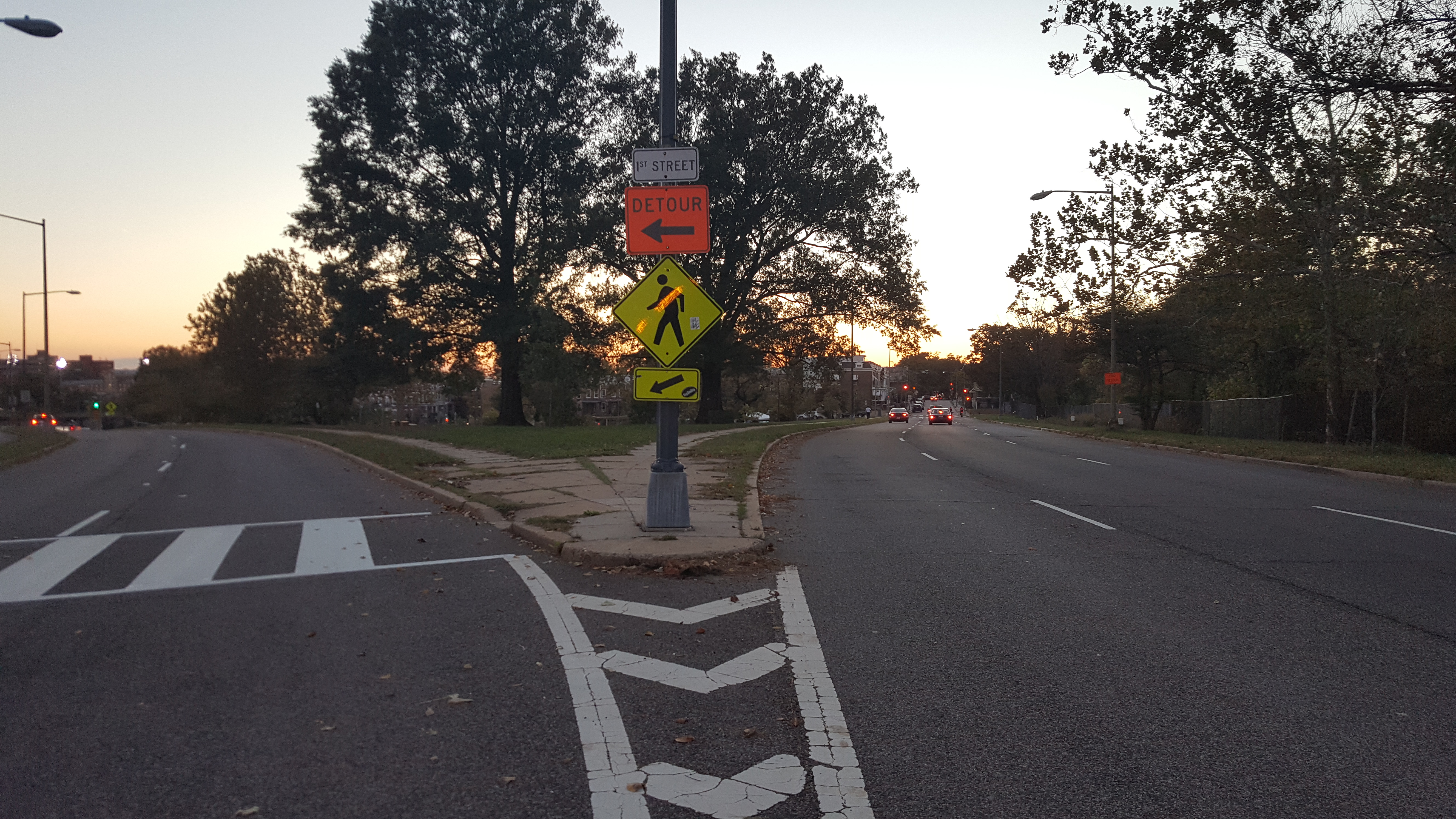
The intersection of Irving and Kenyon Streets. Photo by Nicole Cacozza.
Where Irving Street runs into Michigan Avenue in Brookland, there will again be a two-way protected bikeway. Then, at Michigan Avenue and Monroe Street, there will be marked bike lanes on either side of the road until South Dakota Avenue NE.
The plan will also install another option for cyclists who turn off Michigan Ave onto Monroe Street through Brookland. A meandering sharrow will “wiggle” through the neighborhood to give cyclists a route where they’ll encounter fewer cars.
There will be dedicated bus lanes
The buses that travel these routes often hit bottlenecks and run slowly. To combat this, another major focus of the plan is making those transit routes faster and more efficient. DDOT hopes to combat sluggish buses with a series of dedicated and shared bus lanes.
Michigan Avenue will have a shared lane from Harvard Street to the hospital, but at First Street NW that lane will become a dedicated bus lane stretching farther east towards Brookland. In Columbia Heights, two one-way streets, Irving and Columbia Road, will be split into car and transit lanes: buses will have a dedicated lane going east on Irving and west on Columbia.
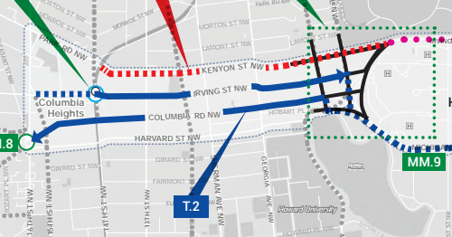
Here, and in the map directly below, the dark blue lines are dedicated bus lanes.
 .
.
Walking around won’t be so dangerous
The plan also highlights intersections that need more appropriate signaling for the amount of foot, bike, and car traffic that they see. At 14th and Irving Street, the site of the Columbia Heights Metro Station, DDOT will create a dedicated crossing time for pedestrians only— the design should be somewhat similar to the “Barnes Dance” intersection at H Street and 7th Street in Chinatown. The Columbia Heights intersection is extremely busy, and this kind of change could ease commuter congestion and keep the crossing safe.
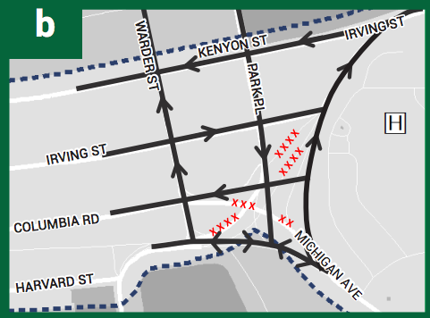
The final plan will also simplify a collection of intersections in Columbia Heights, west of the hospital. The proposal will remove the Michigan Avenue overpass as well as a service road and a segment of Hobart Place NW in order to create a street grid. Cleaning up the arrangement of streets will improve cycling and walking conditions by slowing cars and getting rid of the high-speed ramp, as well as eliminating unsafe intersections where multiple streets arrive at a single light.
A new street grid.
No more cloverleaf
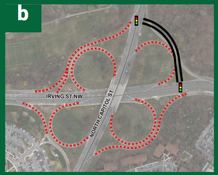
DDOT also recommends modifying the cloverleaf ramps at North Capitol and Irving St to create a simple intersection with one traffic light. This will help regulate traffic speeds, and give cyclists and pedestrians a safer crossing by providing a clear view of all oncoming cars. It will also add green space to the area.
The cloverleaf is on its way out.
When will all this happen?
The time frame varies for each project based on the cost, complexity, and partnership with other agencies. Some projects, like the sharrows in Brookland, only need to go through the design and construction phases and could start in 2017. Others, like the bus lanes, where DDOT will need to work with WMATA, will take more time.
The measures furthest from completion are the cloverleaf change and the creation of the street grid, which will require significant planning. Both projects are slated to begin in 2021, but will take years to finish.
The changes that DDOT has planned will be necessary to manage the new residents and commuters using this corridor. Though we are still a few years out from some of the major project milestones, hopefully today’s plan indicates that transportation will be ready to keep up with growth.