The FBI building’s new owner will be allowed to build tall, and D Street is coming back
Reconstructing D Street NW and allowing buildings taller than DC’s usual height limit are likely at downtown’s J. Edgar Hoover Building, once the FBI moves out. The National Capital Planning Commission’s staff backed these proposals, and today the official commissioners will likely accept them. The staff left a third question, how wide the sidewalks should be on Pennsylvania Avenue, up for debate.
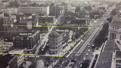
Photo of the J. Edgar Hoover Building site before its construction, with lot boundaries outlined in yellow. Photo from NCPC.
The single brutalist building sits on two parcels, called “squares,” which D Street bisected before the 1960s. The FBI plans to trade the land with a developer (where it would move is TBD), and the NCPC’s decision will make clear exactly what could be built on the land once the FBI moves out.
The first recommendation from the NCPC staff is to return the 70-foot wide swathe of land where D Street once ran to a public right-of-way. That doesn’t mean this space will be a typical street. Since the rules are just shaping the building’s mass, NCPC’s staff left open the door open for other possibilities, like pedestrian-only and pedestrian-priority woonerf spaces between the two restored blocks.
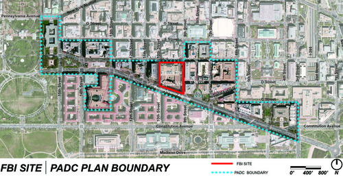
The FBI site in the Pennsylvania Avenue special planning area. Image from NCPC.
The North block will be tall and dense.
The second rule NCPC is poised to adopt is that buildings on the large northern block, called Square 378, will rise to 160 feet. The 1910 Height of Buildings Act specifically allows buildings along Pennsylvania Avenue to climb that high, measured from Pennsylvania Avenue. The 1974 plan that created these square guidelines has sculpted the surrounding cityscape, so although some buildings reach 160 feet by the White House, those buildings’ bulk steps back in tiers several times away from Pennsylvania. The Newseum is a great example: it’s only 90’ at the Pennsylvania Avenue property line, but rises to 140’ at the apartment building at the rear.
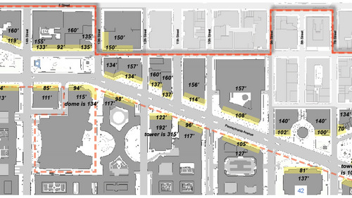
Maps showing heights around the FBI Building. Buildings to the west (left) tend to be taller. Map from NCPC.
Buildings on the north block also have to fill out much of the block on the first floor. Because of its size, the block will almost certainly end up as a few different buildings above grade. The 2016 D-7 zone caps offices and hotel density, but allows unlimited apartment density, and planners will likely insist on some mix of uses. Plus, with buildings aligned to the property lines, the likelihood of an internal semi-public central space, similar to CityCenter, is higher.
The southern block is wedged between priorities
The future of the southern, triangular block is more complicated because of the way Pennsylvania Avenue was reimagined in the 20th Century. In order to shape the scenic view up and down Pennsylvania Avenue symmetrically with Federal Triangle, planners want the new buildings to have horizontal setbacks, like New York skyscrapers. More importantly, the size depends on how wide planners choose to make the sidewalk on Pennsylvania Avenue.
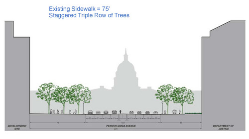
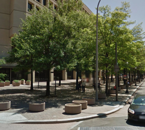
The current building is set back 75 feet from the curb, which is enough for three rows of trees. Image from NCPC
The current FBI Building sits nearly 75 feet away from Pennsylvania Avenue’s curb and 40 feet from the property line laid out in the L’Enfant Plan:
That’s the result of a 1964 plan that envisioned the avenue as a grand federal space and nothing else. Providing space for parade grandstands was more important than street activity. Later planners went for a more modest setback, but recently, facades have risen close to the property line, as at the Newseum.
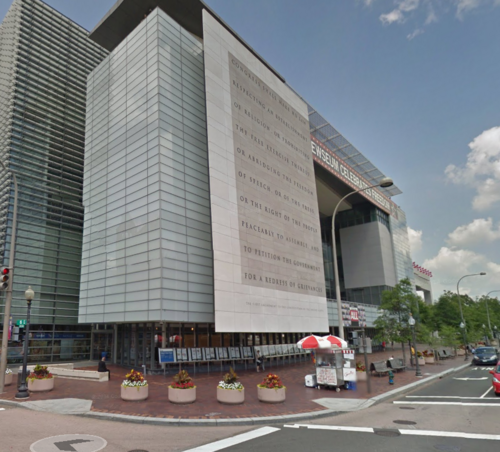
The Newseum is much closer to the street than the FBI building.
With a re-opened D Street and a 50-foot sidewalk, the south site will be small. Leaving a larger footprint seems like the best way to get an active ground level. Setbacks a few floors up would protect the views and leave a large enough footprint for uses other than high-end residential, at least at the lower levels.
The NCPC report leaves this issue up for debate, apparently because of a conflict between two roles it has to uphold. One is to preserve the 1974 Pennsylvania Avenue Plan that created these guidelines in the first place. The other is preserving the L’Enfant Plan, which says buildings should rise at the property line. In fact, the District’s Historic Preservation Office feels that not building to the property line would have a negative effect on the L’Enfant Plan. Their objection might be a formality, but it’s enough to leave it up for a longer debate.
It comes down to the roadway
NCPC’s staff mildly recommends mirroring the setback on the south side of the street, at Federal Triangle, to create a more symmetrical streetscape and leave generous sidewalks to handle the crowds. Where buildings rise from the historic streets, like between Sixth and Seventh Streets, the 20-foot sidewalks can get crowded.
This rationale leaves out an important detail: the reason those sidewalks seem crowded is the width of the roadway.
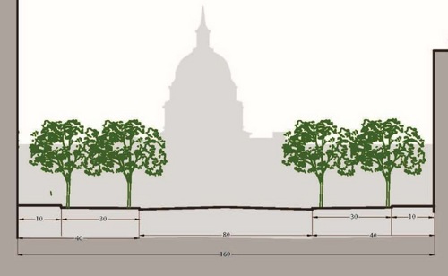
L’Enfant’s design for Pennsylvania Avenue had an 80-foot roadway, 30-foot sidewalks, and 10-foot buffers. Image from NCPC.
There’s nothing sacred about that width. In the 1790s, Pierre L’Enfant envisioned a much narrower roadbed there. Then, at the cusp of the automobile age, the McMillan Commission and others decided to widen Pennsylvania Avenue to make it more striking. As with the other roads widened in the wake of this plan, the reality of streets congested with fast moving vehicles was obscured behind glamorous renderings of grand boulevards.
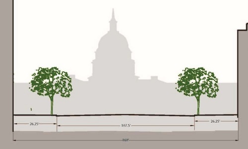
The McMillan Commission and its successors widened the roadway to 107.5 feet. Image from NCPC.
The truth is that Pennsylvania Avenue will never be symmetrical. On the north side, multiple landmarked buildings rise taller than Federal Triangle. One side will have some street bustle, the other will be formal. It may be better to accept this asymmetry and design around it.
While part of NCPC considers what will replace the FBI building, other staff are studying how to make Pennsylvania Avenue more lively in the long term. If that’s the goal, right-sizing the street is the best way to get the sidewalks to handle crowds. It wouldn’t be the first time space allocated to cars in the early 1900s was returned: the two gravel paths on the Mall were turned over to cars for decades before pedestrianization in the 70s. The aesthetic impact remains the same.
NCPC planners will move on to finer grained detail with today’s decisions out of the way. A reopened D Street and a dense north block are steps in the right direction. Planning the south block for a future where pedestrian space and monumental views aren’t beholden to car traffic follows as well.