Here are the answers to whichWMATA week 79 plus “Where’s that Bikeshare?”
On Tuesday, we posted our seventy-ninth photo challenge to see how well you knew Metro. I took photos of five Metro stations. The answers are below, and if you scroll past them, you’ll also find the answers to last week’s Where’s that Bikeshare?”

Image 1: L’Enfant Plaza
This week we got 41 guesses. Sixteen people got all five correct. Great work, Roger Bowles, Peter K, Trey, Andy L, Chris H, PieSuperPAC, Solomon, JamesDCane, FN, Travis Maiers, Donovan S, StephenC, Exit 130, Aaron R, Justin…., and We Will Crush Peter K!
The first image shows a sign on the lower level at L’Enfant Plaza. These signs are mounted on the concrete columns supporting the upper level of the station and are probably intended to shepherd easily-confused tourists onto trains headed toward Smithsonian, one stop west.
The other main clue is the vault wall. As opposed to the other downtown transfer stations and all the other underground vault-type stations, the vault wall at track level is vertical.Everywhere else, the vault slopes away from the trackbed before arcing through vertical higher up. The coffers here also start higher off the trackbed than they do at other waffle stations.
Twenty-seven got this one right.
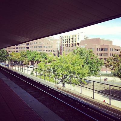
Image 2: Braddock Road
The second image shows the view from the platform at Braddock Road. One primary clue is the Alexandria peak canopy, which appears only at Braddock Road and King Street. Additionally, the buildings in the distance could have helped you narrow this down. One even has a logo, “NIB,” which indicates that the building houses the National Industries for the Blind.
Thirty-two figured this one out.

Image 3: Fort Totten
The third image shows the view looking north along the southbound Green Line platform at Fort Totten. There were a few clues here. For one, the gull canopy intersecting the mezzanine above. Except at Cheverly (which has side platforms) and Fort Totten, no other gull I station has a mezzanine above the tracks.
Additionally, the tunnel portal in the distance means this has to be Fort Totten. At no other gull station do the tracks emerge from underground so close to the station or with a vertical portal face. Most of WMATA’s subway portals have v-shaped openings above the tracks instead of square vertical openings.
Thirty knew the right answer.
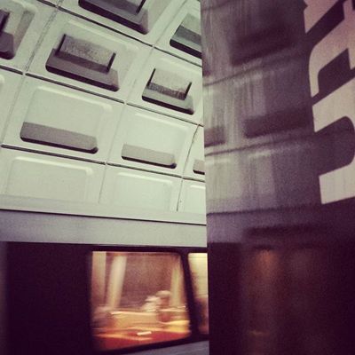
Image 4: Capitol South
The fourth image showed a platform pylon at Capitol South. Most of you easily figured out that the sign text ended with “uth,” and correctly deduced that the only station name ending with those three letters was Capitol South. Other incorrect guesses included Farragut North and Georgia Ave-Petworth, but the letter before the t can’t be an r. In fact, given Helvetica’s character forms, it could only be d or u.
Thirty-five solved the puzzle correctly.
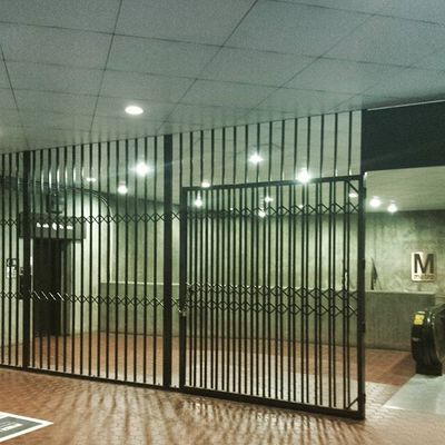
Image 5: Union Station
The final image shows the concourse level at the northern entrance to Union Station station. This is a familiar entrance to those who transfer daily between commuter trains at Metro, so many of you may have recognized it immediately. Another clue included the gate and grating (used to seal off the station when the system closes each night). At most stations, the gates are narrower and paired, like a set of double doors. Here, though, the gate is much wider and swings from one side only.
Additionally, the elevator here is a clue. At most stations, the elevator leads from the mezzanine to the street directly, so it’s not indoor at the “up” end. You can tell that this is the upper end thanks to the down escalator at right and the grating here means that the photo was taken from outside the station. Finally, the flag visible to the left of the Metro logo narrowed the possibilities down, since flags (and the Metro logo) are only mounted at major stations.
Twenty-nine got it right.
Thanks for playing! We’ll be back in two weeks with our next quiz.
Information about whichWMATA contest rules, submission guidelines, and a leaderboard is available at http://ggwash.org/whichwmata.
Where’s that Bikeshare?
Last week was the third time we’ve run another kind of mystery post: Capital Bikeshare’s “Where’s that Bikeshare?” We ran five images of CaBi stations and, like in whichWMATA, challenged you to identify them. Below are the answers:
Images 1 (left) and 2 (right). All images from Capital Bikeshare.
1. 37th and O Streets NW. That’s no mere estate behind the stone wall — it’s Georgetown University. The building poking it’s head over the wall on the left is the Dean’s building of the Jesuit university, not a church.
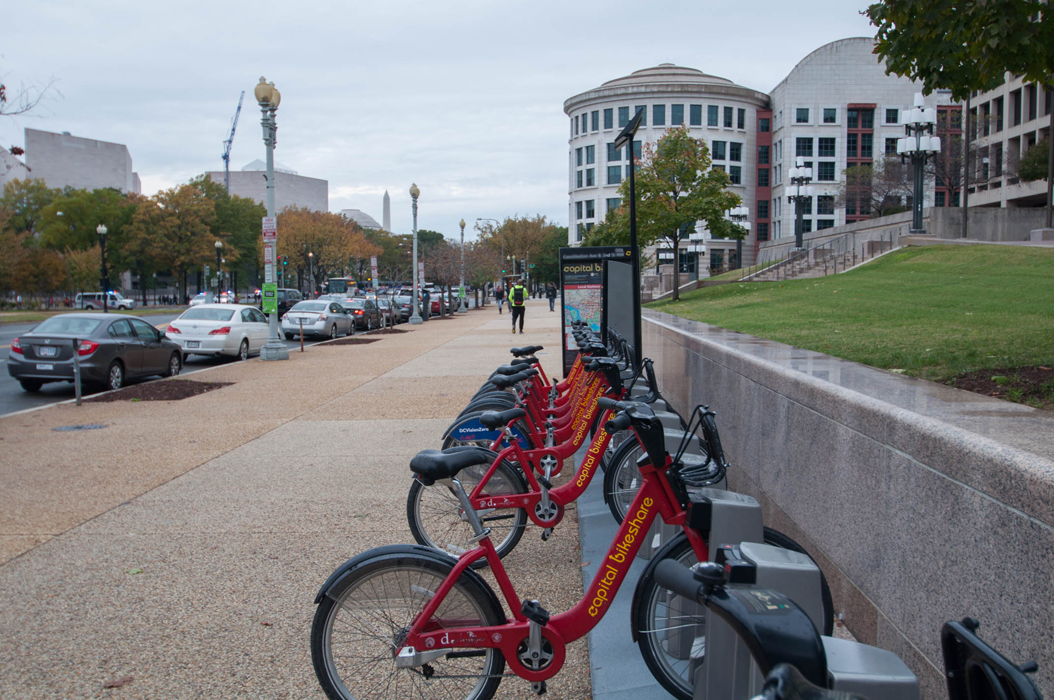
2. Constitution Avenue and 2nd Streets NW. The skyline of the National Gallery of Art, and the Washington Monument above it, make this a familiar sight for congressional staffers and tourists alike.
Images 3 (left) and 4 (right).
3. Dupont Circle. One of just a few stations with two rows of bikes, Dupont Circle is the only one in which this occurs for just a portion of this station. The sheer number of docks also give this one away as the system’s largest station.
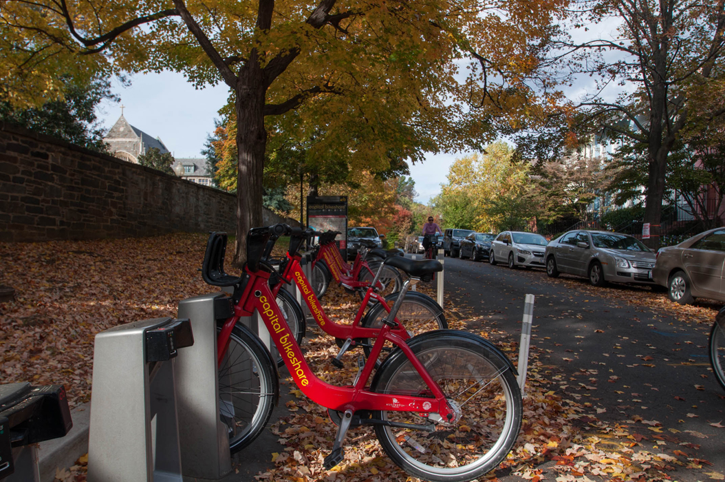
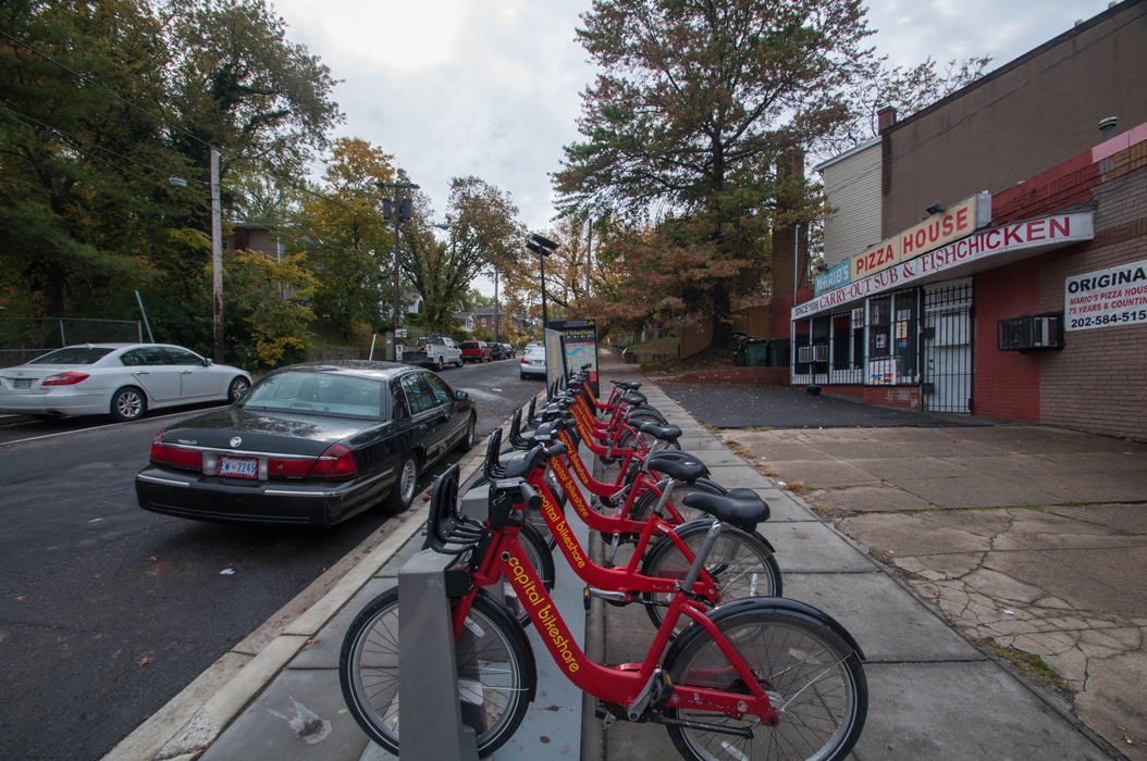
4. Pennsylvania Ave and Minnesota Avenue SE. This station is located next to Washington mainstay Mario’s Pizza House, which is your first clue. The second is the slope of the hill, characteristic of the topography east of the Anacostia river.

Image 5.
5. Washington Boulevard and South Walter Reed Drive. Sandwiched between a major road and a gorgeous trail, this station is a commuter connection for many DC-bound Arlingtonians. You’ll notice the highway signs says Ft. Myer and Columbia Pike, giving you a clue as to where this trail is heading.