These two Prince George’s neighborhoods show how bike trails help neighborhoods
Riverdale Park and East Riverdale are two neighboring communities just east of Hyattsville in Prince George’s County. One is thriving while the other has struggled. One reason could be that the Riverdale Park is near bike trails, while East Riverdale is blocked from them.
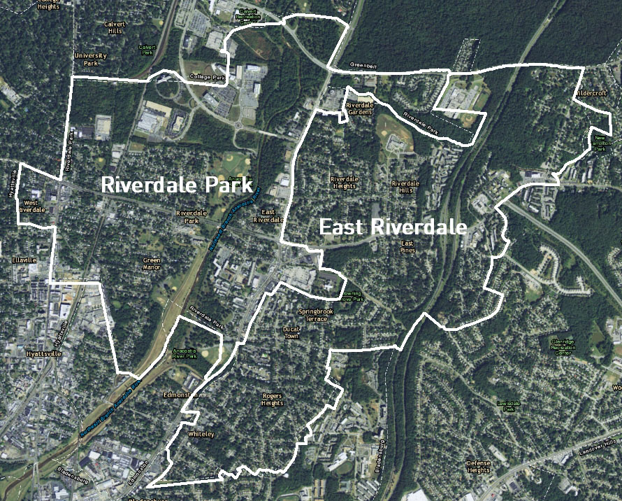
Riverdale Park and East Riverdale. Image by Dan Reed. Base map from ESRI, with boundaries from the Census Bureau.
As part of an effort to extend the WB&A Trail south toward DC, Bike Maryland and the Washington Area Bicyclist Association studied property values and housing patterns in several Prince George’s county neighborhoods. The large differences in property values between neighborhoods with close proximity to bike trails and other nearby communities with few non-car transport options was striking.
As part of the study, the organization divided whole communities into those that have good access to trails (Hyattsville, Riverdale Park, Edmonston) and those that have poor bike access or are otherwise “carlocked” by major uncrossable roads (Woodlawn, East Riverdale, Landover Hills). They also looked at properties within 200 meters of a bike facility and those beyond 200m of a bike facility, both within communities and overall.

A heat map of bike infrastructure in Prince George’s County. The area where Bike Maryland and WABA want to expand the WB&A Trail is circled in yellow. Image from Bike Maryland.
Two neighboring communities highlight the contrasts
For example, let’s compare East Riverdale, where there is no safe place to bike or walk, either for recreation or for commuting and utility, with Riverdale Park, where there are far more options.
Riverdale is a burgeoning community with a lively farmer’s market, a nascent craft beer scene, a weekly blues jam, and easy walking and bike access to the new Hyattsville Arts district and a revitalized Route 1, which has several new restaurants. A trendy new development anchored by a Whole Foods market is under construction just north of town.
But East Riverdale, which is just across Route 201, has been designated as a Transforming Neighborhoods Initiative community, meaning it faces “significant economic, health, public safety and educational challenges.”

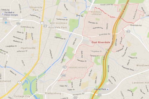
Riverdale Park. Base image from Google Maps.
East Riverdale. Base image from Google Maps.
Median housing values are more than $30,000 higher in Riverdale Park ($246,200) than in East Riverdale ($215,500), and assessments are about $50,000 higher ($215,800 in Riverdale Park vs. $163,700 in East Riverdale). Riverdale Park’s value per acre ($995,000) is nearly 10 percent higher than East Riverdale’s ($908,000).
Houses in East Riverdale are actually newer and larger than those in Riverdale Park. East Riverdale also has more single-family housing and fewer buildings with large numbers of units, there’s more owner-occupied housing, and its houses have more rooms; all of these things are often associated with higher home values.

The demographic characteristics of the residents in Riverdale Park and East Riverdale are similar, with approximately half of the residents of Hispanic of Latino heritage (48% in Riverdale Park vs. 53% in East Riverdale). Downtown Riverdale Park has a MARC commuter rail station with some charming pre-WWII homes and cottages nearby, although the commercial area around it seemed relatively lifeless and contained several abandoned buildings until recently. On balance, looking at individual street views of East Riverdale’s and Riverdale Park’s housing stocks, it is certainly not obvious that East Riverdale would have dramatically lower housing values.
It’s quite possible that the reason Riverdale Park is being revitalized while East Riverdale has struggled economically goes back to basic community design: East Riverdale’s layout forces residents to drive everywhere, and residents can’t easily walk to the market or ride their bikes to work.
Meanwhile, as younger residents who are not particularly attached to driving look for affordable place to live, Riverdale Park is a more attractive choice. The new energy attracted to the neighborhood creates an upward cycle of renovation.
To note: The comparison data on the housing characteristics and demographics of households in East Riverdale and Riverdale come from the US Census American Community Survey (ACS) for 2009-2013. Tax valuation data are from PG Atlas, gathered in June and July of 2015.
Can transit turn East Riverdale around?
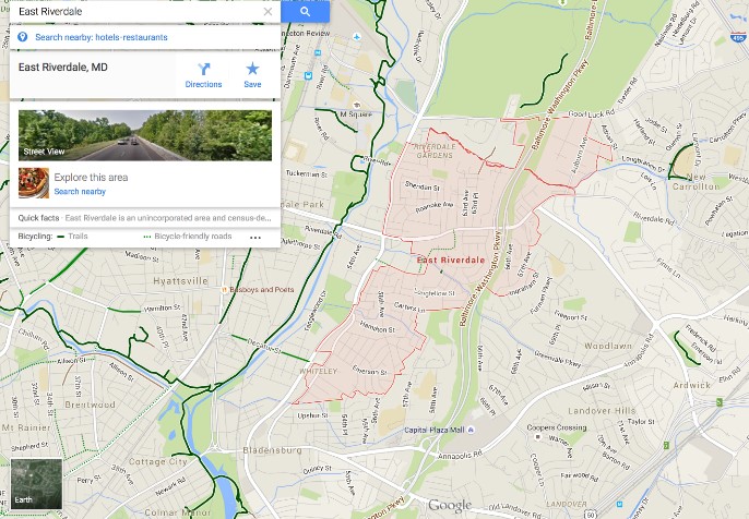
Caption: East Riverdale is Blocked from the Anacostia Tributary Trails by a Major Highway, MD Route 201; map by Google maps.
It’s possible that the Purple Line, which will affect East Riverdale more than Riverdale Park, may switch economic momentum back to the east over the next 10 or 20 years. The Purple Line and its feeder walks and bike routes (if any) should make it easier to get around without a car.
Granted, a more desirable neighborhood layout, with more transportation options, will attract higher income residents, who, in turn, attract more businesses and amenities, making the neighborhood even more desirable in an self-reinforcing cycle. It is very difficult, and can be a fool’s errand, to try to accurately say that any one item makes a neighborhood more or less desirable when every contributing factor is related to every other!
But we certainly want to make county leaders aware of the fact that the carlocked neighborhoods in Prince George’s County contribute much less per acre to county’s tax rolls than trail-accessible neighborhoods. We hope our county will agree to build more great bike trails in the county and thereby test our hypothesis that unlocking carlocked neighborhoods could lift whole communities!