The feds own RFK. Here’s what they plan to do with it.
There’s been a lot of talk lately about what to do with RFK Stadium and the land around it. One detail that’s largely been left out of the conversation: the federal government owns the entire 190-acre site, and it has already developed and adopted an ambitious plan to fill the site with mixed-use development, recreation, and culture.
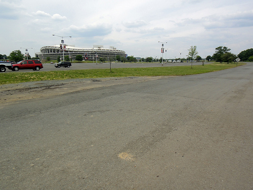
This parking lot should be active recreation, according to its owner. Photo by the author.
Some have made the occasional calls for sports facilities, like a football stadium or an Olympic arena. RFK’s 10,000 parking spaces are also frequently brought up as the solution to any land-use challenge the area faces, particularly new housing.
But since the land underneath RFK is part of the National Park Service’s Anacostia Park, the site is owned by the federal government and the National Capital Planning Commission will ultimately decide what to do with it.
NCPC is a federal agency which “preserves and enhances the… federal assets of the National Capital Region to support the needs of the federal government,” and it’s the federal agency that “coordinates the planning efforts of federal agencies that construct and renovate facilities within the National Capital Region,” an authority granted to it under the National Capital Planning Act.
So what does NCPC envision for this “dramatic gateway to the city,” half the size of the National Mall? In December 2006, the agency published an “RFK Stadium Site Redevelopment Study” [PDF] that envisions “a lively destination for residents and visitors,” with “new cultural and commemorative uses to attract visitors” plus “residential and neighborhood commercial development in this area of the city that is ripe for revitalization,” and a chance to “address the recreational needs of local residents.”
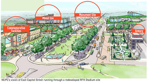
Image from NCPC.
Here are the particulars of the plan:
- Active recreation on 80 acres along the waterfront, replacing the existing parking lots. Not only would new parkland provide considerable space for a city that, while long on total park space, is often short on space for sports. The new parkland would also provide almost enough space to double DPR’s existing inventory of 47 playing fields. Returning the site to green space, with a generous natural buffer and trail along the river’s edge, would improve water quality in the Anacostia River and reduce the impact of future floods. Note that the parking lots are almost entirely below 10 feet above sea level, and thus within the Anacostia River floodplain. They cannot be developed without first raising them out of the floodplain, either by building heavy-duty seawalls or by trucking in lots of dirt.
- Memorials or museums, on two sites totaling 45 acres: a 30-acre parcel encompassing the existing stadium, and a 15-acre parcel across from the DC Armory. The 30-acre site might be an outdoor memorial on a site slightly larger than the Gateway Arch site in St. Louis, or could house a cultural complex larger than the National Gallery of Art’s entire campus. The 15-acre site could house a museum, performance house, aquarium, or civic building of 300,000 to 800,000 square feet — about the size of the National Museum of the American Indian on the smaller end, or the National Museum of American History on the larger end. Unusually for a site in DC’s neighborhoods, a large and wide building (perfect for a museum) wouldn’t look out of place on this site, since it faces the Armory and Eastern High School.
- 20 acres for mixed-use development, roughly between the Armory and the existing stadium, between 21st and 22nd St. NE, and Independence Ave. SE and C St. NE. The site can accommodate 1.2 million to 2 million square feet of development, in buildings ranging from mid-rises (70 to 90 feet tall) at the center of the site down to low-rises (40 to 60 feet tall) at the edges. The buildings would be no higher than the existing Armory, whose existing ceiling is 88 feet tall. The scale of development NCPC identified would be somewhat smaller than what’s been built so far at CityCenterDC, or two or three times as large as the Monroe Street Market development at the Brookland Metro. If it were predominantly residential, it would accommodate up to 2,000 housing units at a mix of sizes, plus neighborhood-serving retail and office. The heights that NCPC identified wouldn’t be high-rises, but rather relatively more affordable mid-rises.
NCPC identified these three uses for the site as far back as its 1997 “Extending the Legacy” plan for the region, released the same year that FedEx Field opened. That plan “envisioned the site with a major memorial surrounded by new housing and commercial development.”
There’s room for all three uses
Precedent also exists for the happy coexistence of all three uses in urban national parks. For instance, when the The Presidio in San Francisco was added to the Golden Gate National Recreation Area, its five million square feet of buildings (including residences, offices, and educational uses) were retained by a new trust that supports park restoration and programs.
Some citizens are calling for DC to fulfill at least part of NCPC’s plan by converting the northeast parking lots into a youth sports park and green space. That can happen without changing the terms of the National Park Service lease, as can future active or passive parkland on the southeast lots.
Any changes to the central part of the site, around the Armory and on the existing stadium footprint, would require negotiations between DC and the federal government. If that happens, DC should respect the federal government’s wish to build a new neighborhood, and space for year-round recreation and reflection.