A new ramp is coming to I-395. It’ll be a little better for pedestrians and a little worse for buses.
New buildings will soon cover part of the I-395 highway in downtown DC and knit back together the disconnected street grid. As part of that, an on-ramp to I-395 will move to a new location in the middle of Massachusetts Avenue. Here’s what that will mean for everyone.
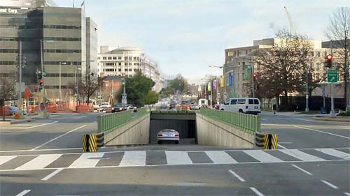
Rendering of the proposed ramp, from the project construction website.
The Capitol Crossing project will build four office buildings and one residential building atop the section of I-395 that runs for three blocks between Massachusetts Avenue and E Street. The developer is building a platform over the highway for the buildings, which will also reconnect F and G Streets.
This will bring new economic activity and residents to the area and remove a giant barrier that makes Georgetown Law School, on the east side of the highway, and the blocks west of Union Station feel very disconnected from the Judiciary Square vicinity and the rest of downtown to the west.
Where the new ramp will go
The project will also build a new ramp onto I-395 from Massachusetts Avenue. Currently, there is a ramp from southbound 3rd Street to the freeway. That ramp will be rebuilt and possibly moved as part of the project.
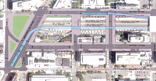
Alternative 3. North is to the left.
The ramp will move the middle of Massachusetts Avenue, between 4th and 3rd. Drivers headed east on Massachusetts would cross 4th and then immediately drop down into the tunnel.
There were three options initially proposed. The other two would have kept the ramp closer to its current location, where it splits off from the left side of 3rd Street headed southbound.
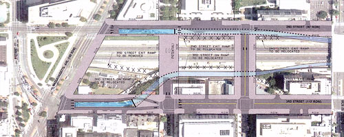
Alternative 1. North is to the left.
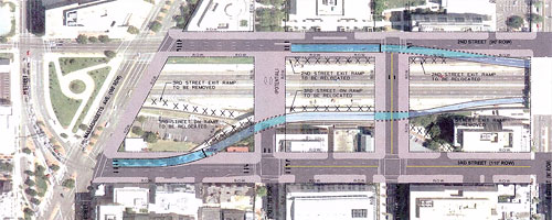
Alternative 2. North is to the left.
Alternative 2 just moved the ramp slightly. But one big problem with this ramp is that someone walking on that sidewalk has to cross a high-speed highway onramp to continue. Alternative 1 instead has the ramp drop down from the middle of 3rd, then cross under a traffic lane and the sidewalk to get to the highway.
The alternatives also have slight differences in the corresponding off-ramp, which exits onto 2nd Street, but they are not very different. All would have the off-ramp rise between the road and the sidewalk, creating a continuous sidewalk along what’s now the highway edge but will ultimately be the Capitol Crossing buildings.
Moving the on-ramp to the middle of Massachusetts will block the space where H Street crosses Massachusetts today. The two meet in four separate smaller roadways, one for drivers going east on H and three for drivers coming west to go to 3rd, H, and Massachusetts respectively.
Instead, there would be one angled road to 3rd while the main part of H would come to the intersection of 4th and Massachusetts. Drivers wanting to get to H Street would turn left on 4th and then right again on H, while vehicles going east on H would have to merge onto Massachusetts and then make a sharp left onto 2nd, as drivers on Massachusetts have to do today to get to H.
Will this hurt the X2 bus?
In a letter, Councilmember Mary Cheh expressed concern with the choice. Cheh says that these sharp turns would mean that “the X2—the busiest bus line in the District—would almost certainly have to be rerouted.”
It might not come to that; WMATA spokesperson Sherri Ly said in an emailed statement,
Metro provided input during the early planning phase and will continue to work with DDOT on the selected design. With regard to your specific question about the X2, it is our understanding that it will function physically, as the curb radii would be made appropriate to the turning requirements of the buses, as was done in the first phase of the traffic mitigation effort.
The Finding of No Significant Impact — the environmental document which justifies why this project won’t have a negative environmental effect — says, “There would be an adverse effect on Metrobus routes running along H Street (X2, X9, and 80),” likely in the form of longer travel times to navigate the intersection. Though, the associated Environmental Assessment says that this impact is the same on all three options.
Is this good for pedestrians?
This change is clearly better for anyone trying to walk along the east side of 3rd Street. Today, anyone on that sidewalk has to cross the high-speed highway on-ramp, which cuts right through the sidewalk; the new design means a contiguous sidewalk on 3rd. Likewise, the intersection of H and Massachusetts will have many fewer road segments pedestrians must cross.
In a response to Cheh, Deputy Mayor Brian Kenner says that the change “will reduce the capacity on Massachusetts Avenue and reduce the volume of traffic accelerating from eastbound Massachusetts Avenue to enter the highway at 3rd Street, resulting in a more pedestrian-friendly crossing.”
However, if the crosswalk markings are accurate, it also looks like this change will force pedestrians to walk somewhat out of the way to follow Massachusetts Avenue. On the displayed Alternative 3 plans, there are a number of missing crosswalks, where people would have to turn onto a side street and cut back over to remain on Massachusetts.
Even though legally there is a crosswalk, whether painted on or not, at each leg of an intersection, DC often omits crosswalks where diagonal avenues meet other streets because traffic engineers won’t design the intersection around letting pedestrians walk everywhere they legally can and should be able to.
However, these might not be the final crosswalk markings — for instance, this diagram shows no crosswalks across 4th Street, which can’t be correct. I’ve asked for more information about the actual crosswalk locations.
Is this good for drivers?
Cheh also asked about drivers coming from the east who could no longer use the ramp. They instead would drive down 3rd Street to the next entry point at D (underneath the Department of Labor’s Frances Perkins Building).
Kenner quotes the EA and FONSI which say that the change will “redistribut[e] traffic volumes throughout the [street] network,” and writes that the EA/FONSI estimated about the same level of traffic in all three alternatives.
The whole project is expected to take about five years from spring 2014, or until 2019. You can keep up with the latest progress here.