A dedicated bus lane and 30 other ways to improve bus service on 16th Street
A full-time bus lane on 16th Street, or a rush-hour only lane, are two of many possible strategies for improving bus service on 16th Street. DC transportation planners presented a menu of ways to make these buses faster and more reliable at a meeting Wednesday night.
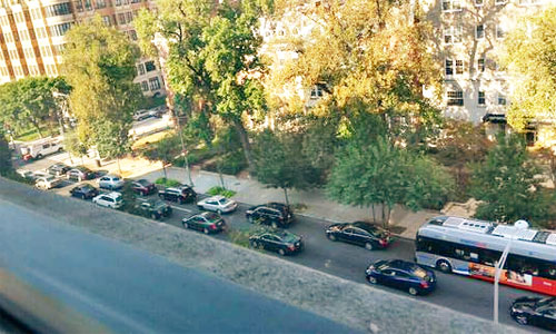
A bus in traffic on 16th Street. Photo by Kishan Putta on Twitter.
The District Department of Transportation (DDOT) has been studying 16th Street in detail from Spring Road to Lafayette Park. Planners scrutinized the buses’ operations to figure out how much time buses were waiting for people boarding, at lights, and more.
Now, they’ve devised three scenarios. Each scenario combines a host of individual changes, from small ones like lengthening a bus stop to major changes like a bus lane. After getting some more public input, the team will run them through traffic models.
Ultimately, they will be able to mix and match pieces, so rather than focusing too much on what’s in each scenario, here is a list of some of the most significant ideas to think about.
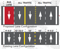
A full-time bus lane (in scenario 2): 16th Street south of Spring would get a bus lane in each direction, a general travel lane in each direction, and a reversible lane. Between U Street and O Street, where 16th Street is 48 feet wide, it would become 5 narrow lanes (with the middle one reversible) instead of the current 4 wide lanes. That would ensure that drivers in the peak direction still get two lanes as they do today.

Typical lane configurations for scenario 2 in Columbia Heights (left) and Dupont (right). Click for a detailed diagram of the corridor with lane configurations for all portions. Images from DDOT.
A rush-hour bus lane in the peak direction (in scenario 3): During morning rush, 16th would have a southbound bus lane and two southbound general travel lanes; the reverse would apply in the evening. Through most of Columbia Heights where 16th is already 5 lanes, that means one reversible lane (like today). In the narrow part from U to O, it would stay four lanes, but in this scenario, would have two reversible lanes.
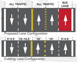
 Typical lane configurations for scenario 3 in Columbia Heights (top) and Dupont Circle (bottom) in the AM peak (left) and PM peak (right). Click for a detailed diagram of the corridor with lane configurations for all portions. Images from DDOT.
Removing a few bus stops (all scenarios): In some places, bus stops are very close together, like a stop at Riggs Place southbound which is between other stops at Q and R. Planners suggest removing southbound stops at Newton, Lamont, V, and Riggs, and northbound at L, Q, V, Lamont, and Newton.
Queue jumps (scenario 1): If there is no bus lane, there would be a few “queue jump” areas where buses could go ahead of other vehicles at a signal. For instance, northbound at U Street, buses now pull out into a combination bus stop and right turn lane, but then have to wait to merge back in when the light turns green. A special signal could let the bus go first if it’s waiting.
Headway-based service (all scenarios): Now, buses operate on a schedule, where each bus leaves at a predetermined time. The Circulator, instead, uses a headway system where they leave each end whenever it would space out the buses at the appropriate time intervals (10 minutes for Circulator). The S buses would start using this same system as well to try to reduce bunching.
Other bus stop tweaks (all scenarios): Southbound, the stops at Harvard and M Streets would move to the far side of the street, which will also make it possible to lengthen them. Other stops would get longer as well.
Off-board fare payment: There are three ways to do this. One (in scenario 2) would be to just add kiosks at bus stops to let people load up their SmarTrip cards while waiting for the bus. Loading them on the bus adds a lot of delay.
WMATA is already exploring doing this on five lines, though at the meeting, Megan Kanagy of the study team said that cash transactions on 16th Street represent a low percentage of riders.
Alternately, DDOT and WMATA could work together to set up full off-board payment, where people touch a SmarTrip at a kiosk or pay and get a receipt or something (the exact physical details are not yet worked out). Inspectors would then spot check buses to verify people had paid.

Fare payment kiosks for New York’s 34th Street Select Bus Service. Photo by New York City Department of Transportation on Flickr.
According to the table here this would save 1-4 seconds per rider. People could also then board through both the front and rear doors.
This is a big change, however. One challenge is that it’s hard to do this on only part of a route, since if someone gets on in the non-off-board zone, pays with cash, and then rides into the zone, there’s no way to prove he or she paid. The S1 bus now splits off the other buses at K Street and heads over to the State Department, while the S2 and S4 go east and south to the Federal Triangle area. Therefore, this option would be hard to implement unless the routes also got shorter, as discussed below.
An easier way to get started (in scenario 3) would be just to do this on the S9 express bus, which goes from Silver Spring to McPherson Square and makes fewer stops.
Shorter routes (scenario 1): In addition to the issues with off-board payment, the route split also hurts reliability. Longer routes are harder to keep on time, and when buses start in far-apart spots and then merge, it’s hard to get them to not be bunched up once they merge.
One option, then, is to shorten the downtown sections of each route, having the S1 just go to Farragut and the S2 and S4 just to McPherson.
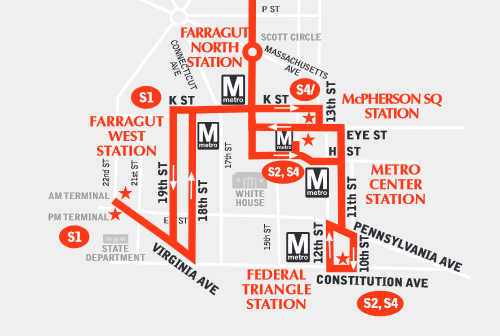
Routes for the S1, S2, and S4 downtown. Image from WMATA.
A big drawback is that especially for the S1, riders won’t have a lot of great alternatives. In fact, Metro is already proposing cutting back the 80 bus to make it more reliable, and it doesn’t run very frequently anyway. According to the data here (page 23), 61% of the riders who take the S1 to the Dupont/U/Columbia Heights area get on in the portion beyond McPherson.
So that doesn’t sound so good right now. But it could be in the future. Transit planning guru Jarrett Walker talks a lot about the value of having a simple network of frequent routes instead of a lot of branching. Rather than giving riders a lot of sub-routes which go different places, just make it easy to transfer (just like with most rail systems).
If Metro were able to more holistically rethink the bus routes downtown, we might end up with a network where all S buses go to the same place, but there’s a frequent, reliable route east-west. Anyone going to the Foggy Bottom area could confidently transfer to that bus without it making the trip much slower or less reliable than the S1 today (or hopefully even better!)
Therefore, it seems this option is worth studying now, but probably not implementing yet. The bigger rethink of bus routes is also worth getting started on.
Fix some intersections: DDOT previously studied of the complicated intersection where Havard, Columbia, and Mt. Pleasant Streets all meet 16th in three very closely-spaced lines. Scenario 2 contemplates going ahead with some changes, though there would be more of a public process first to decide exactly what that would be.
Driving southbound, one lane becomes a left turn lane at W Street, and a lot of drivers either don’t know or try to use that to jump ahead. All scenarios consider starting signs earlier and a physical separator as well.
Limit parking: There are 535 parking spaces in this area now. Ten would go away to lengthen bus stops in all scenarios. Right now, parking is not allowed along the peak direction during rush periods, and in some places is not allowed in either direction during rush.
In scenario 1, there would also be no parking midday (when parking really constrains the buses which have to merge into traffic), but still parking in the off-peak direction mornings and evenings. Scenario 2, the full-time bus lane, would have no parking except for 10 pm to 7 am, when people could park in the bus lane.
Scenario 3, the part-time bus lane, would have no parking on either side during morning or evening rush periods (to make room for the bus lane) but still allow it midday. However, in all scenarios the middday period would not start until 10 am, versus 9:30 today. The many pieces of each scenario are complex, but summarized here (page 22).
Use Arkansas instead of Missouri (scenario 1): Buses driving to or from the bus garage on 14th Street now go north to Missouri Avenue and then south again on 16th. Instead, they could use Arkansas Avenue, just south of the bus garage, increasing reliability.
Weigh in
The team wants to hear from residents before they start running the scenarios through the traffic models. They’re interested in strategies they might not have included and feedback on the ones they did.
There will be four “pop-up” events, where people can stop by, ask questions, and give feedback without having to sit through a long meeting. They are:
- Wednesday, October 7, 5:30-7:30 pm at 16th Street and Spring Place, NW
- Wednesday October 14, 4-6 pm at 16th and L
- Thursday, October 15, 5:30-7:30 pm at 16th and U
- Saturday, October 17, Noon-2 pm at 16th and Irving
And leave your thoughts in the comments. What do you think is best? Anything else that should be part of the mix?