A new highway would improve access to walkable White Flint, but for whom?
The Maryland State Highway Administration wants to build a new highway in White Flint, one of the region’s most celebrated transit-oriented redevelopment efforts.
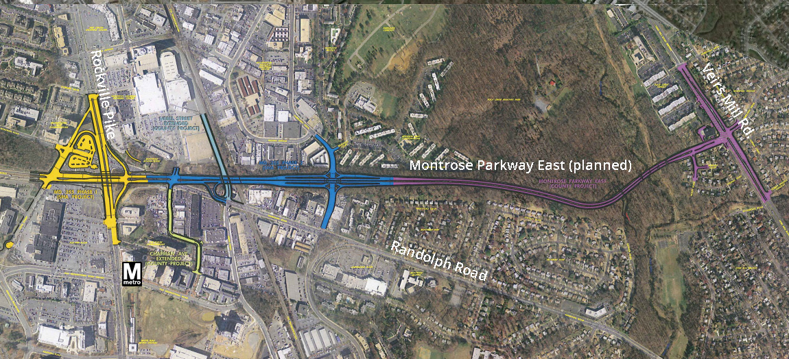
Project map by the author from SHA base map.
White Flint supposedly needs the grade-separated highway to improve access to new developments and the Metro station, bring down congestion, and improve safety. But how well will the project really do these things, and for whom?
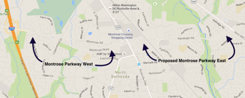
The highway in question is Montrose Parkway East, a planned $119m, 1.6 mile divided highway running between Rockville Pike to the west and Viers Mill Road to the east, paralleling the existing Randolph Road, just north of the White Flint Metro station.
Base image from Google Maps.
Montrose Parkway has been on the drawing board in various iterations since it was originally conceived in the 1960’s as part of a mostly-mothballed Outer Beltway. After years of controversy, Montrose Parkway West opened in 2010 between Tildenwood Drive and Rockville Pike (MD-355).
The highway would “improve” access, but only for people in cars
In engineering-speak, the project would “improve” access for though-traveling motorists by cutting the number of lights they encounter between Rockville Pike and Viers Mill Road.
But those are the only people whose access would “improve.” The project would bring a massive single-point urban interchange (SPUI) to Parklawn Drive. This kind of interchange is the exact opposite of walkable and transit-oriented, which is what’s being cultivated elsewhere in White Flint.

Proposed SPUI interchange at Parklawn Drive and the proposed Montrose Parkway East. Diagram from SHA.
According to emails MCDOT (to whom SHA would eventually turn the project over) has exchanged with Friends of White Flint, the agency supports modifying the exact layout of the SPUI to support the community’s desire to see a more pedestrian- and bicycle-friendly solution. That’s encouraging. The project proposal also incorporates ten-foot mixed-use path on one side and a five-foot sidewalk on the other.
But any intersection and highway of this scale, regardless of the exact configuration, presents a major challenge to knitting a walkable urban fabric. The large scale of the highway and interchange would create a visual and geographic barrier that would discourage walking across such a long distance to reach destinations on the other side.
SHA built a similar intersection a block west from where the SPUI would be built,at Rockville Pike and Montrose, in 2011. There, missing sidewalks force pedestrians to walk on narrow shoulders and across dirt paths, while the crosswalks that do exist are placed at the foot of high-speed on/off ramps.
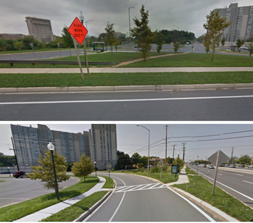
Pedestrian conditions at the existing interchange between Rockville Pike and Montrose Parkway. Images from Google Streetview.
Congestion is declining, even without a parkway
SHA project documents estimate that average daily traffic along the existing Randolph Road will reach 42,000 vehicles by 2020, and suggest that the capacity increases the parkway brings would help mitigate that projected congestion.
Leaving aside that it’s widely understood that giving roads more capacity just leads to more people driving on them, traffic in the area is currently declining. SHA’s own traffic counts for Randolph show that traffic there has decreased by 32% since 2002, falling to 23,052 in 2014.

Graph by the author.
Part of what SHA wants is to improve a railroad crossing
The project’s purported safety benefits relate to an existing at-grade rail crossing on Randolph Road.
The new road would divert much of today’s existing traffic away from the existing at-grade CSX railway crossing at Randolph Street, to a new above-grade crossing on the Parkway. But it would leave open the existing at-grade railroad crossing at Randolph Street, leaving open the possibility of collisions.
More to the point, an MNCPPC analysis found the number of railroad accidents at the existing intersection was negligible compared to the number of collisions between cars.
The highway mindset is still common
This isn’t the first time the State Highway Administration has tried to push through plans for over-engineered roads in White Flint. Last year, the agency provoked an outcry when it sought to widen Old Georgetown Road, backing down only when the County Council threatened to pull funding for the project.
While this gulf between projections and reality may be jarring, it is typical. Transportation and land-use patterns are in the midst of a structural shift, one which many transportation agencies have been unable or unwilling to acknowledge.
The White Flint community supports walkable transit-oriented development, not highways.
Many local residents don’t want to see Montrose East move forward. Residents, property owners and elected officials in the White Flint area have consistently supported the area’s redevelopment into a walkable, transit-oriented activity center, and are organizing with the help of the Coalition for Smarter Growth. Also, Friends of White Flint is organizing an effort to make the project at-grade and walkable.
Montrose East would be a major blow to the walkable, urbanist White Flint vision. Not only would the project extend a physical barrier through the heart of the community, county tax dollars would fund it, at a time when the county cannot afford to advance the Rapid Transit System and is laying off teachers to close a $50m budget gap.
MCDOT’s comment period for the project closes this Thursday.