Here are the answers to whichWMATA week 48
On Tuesday, we posted our forty-eighth photo challenge to see how well you know Metro. I took five photos in the Metro system. Here are the answers. How well did you do?
This week, we got 16 guesses. Six of you got all five correct. Great work, Peter K, JamesDCane, William M, Frank IBC, FN, and Mr. Johnson!

Image 1: Glenmont
The first image shows the eastern entrance to Glenmont station. Structurally, this is a unique escalator covering. But it’s also distinctive because of the artwork Swallows and Stars tiled along the canopy supports.
Today, escalator canopies are commonplace on Metro because WMATA wants to protect the moving stairs from the elements. But before the agency started putting in the standardized glassy canopy, like the one at Virginia Square featured in week 40, they built unique canopies at new stations.
When Glenmont opened in 1998, it was among the first to get a canopy like this. Columbia Heights and Georgia Avenue followed in 1999. Congress Heights included an entrance pavilion similar to the Mid City stations two years later when it opened. Fourteen of you recognized Glenmont.

Image 2: Franconia-Springfield
The second image shows the roof of Franconia-Springfield. The structure, especially the width of the roof, should have told you this was a high peak station. But which of the four could it be?
The main clue was the vantage point. The photo is from the VRE overpass, which is higher than the roof of the station. Southern Avenue and Suitland both have overpasses leading to the station, but their escalator configuration doesn’t allow this view. Six of you guessed correctly.
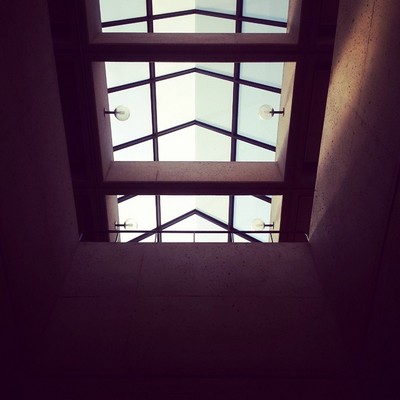
Image 3: East Falls Church
This picture shows the roof of East Falls Church looking up through a “hole” in the platform from the mezzanine. The roof type is general peak, and the perspective means the station’s mezzanine is below the tracks. That eliminates six of the eleven stations of this type. Of the remaining five, only East Falls Church fits the bill.
The crossbars below the glass are closely spaced, which is only the case at East Falls Church, Dunn Loring, and Vienna. And as noted above, you can discount Dunn Loring and Vienna. The other clue is the railing visible at the bottom center of the photo. That’s present only at East Falls Church, and you could (barely) see it in week 46. Eight of you got this one.

Image 4: Naylor Road
The fourth image shows the newest general peak station in the system, Naylor Road. This station is a bit different from the other stations because it has an extremely shallow glass peak.
Note how in the images above (East Falls Church) and below (Addison Road), the peak is angled at roughly 45 degrees, with a right angle at the apex. Compare that to Naylor Road, where the slope is probably closer to 20 degrees above horizontal and the apex is a very obtuse angle. Seven of you guessed correctly here.
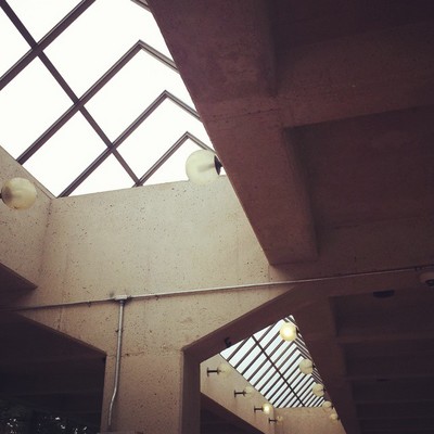
Image 5: Addison Road
The final image shows the canopy at Addison Road. Like the last two images, it has a general peak roof. But Addison Road has a unique variant of the canopy. This is the oldest general peak station in the system, opening in 1980. All of the other general peak stations, except for East Falls Church and Dunn Loring, have two columns supporting the canopy on either side of the peak (see image 4).
Addison Road has a single row of columns centered under the peak. This unique element is the only real clue to solving the final image. And eight of you were able to solve the puzzle.
Thanks to everyone for playing! Great work. Stay tuned. We’ll have five more images for you next week.