New transit in Alexandria could be great, but not if riders can’t walk to stations
Alexandria is planning a new bus rapid transit corridor that could be great for development. But the fenced-off apartment complexes and pedestrian-hostile roads surrounding it could discourage people from taking the bus.
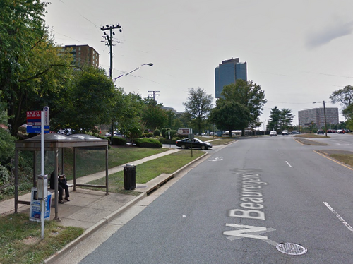
Alexandria’s West End today. Photo from Google Street View.
The West End Transitway is a bus rapid transit system that will run along Van Dorn and Beauregard streets, connecting the Van Dorn Metro station to both the Shirlington Transit Center and the Pentagon. The transitway will have dedicated lanes for buses, meaning it will bring effective transit to an area that needs development.
But the West End neighborhood south of Landmark, whose rough boundaries are Edsall, Pickett, Duke and I-395, contains numerous apartment complexes with fences that block pedestrian connections. Meanwhile, wide, fast roads make walking inconvenient and dangerous. Neither of these things will encourage anyone to use the bus.
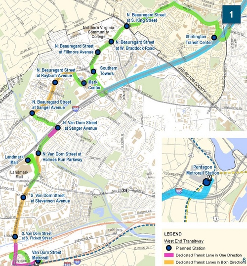
The proposed West End Transitway. Map from the City of Alexandria.
For example, the Edsall Bluff complex on Edsall Road is only about 400 feet from Watergate at Landmark. But to get from one to the other, a resident would have to walk nearly a mile because they’re both fenced in and there aren’t any paths that connect them.
When it comes to transit, walkability is the key to success. The parts of Alexandria that have really high transit use, like Old Town, not only have density but a street grid with narrow, slow streets that makes it easy and safe to walk to Metro and bus routes. Likewise, the West End Transitway needs to be accessible on foot and by bike. If it’s not, it’s going to be hard to call the project a success.
Wide, fast roads make walking unsafe
Alexandria’s plan for the Beauregard Street corridor, which is in the West End, proposes a new grid with streets that slow vehicle traffic and are easy for pedestrians and bicyclists to navigate. But the latest plans for the West End Transitway are full of suburban design, namely wide travel lanes that are between 12 and 14 feet wide, and a lack of on-street bikeways.
Missing are the narrow lanes that are now universally recommended in modern smart growth handbooks. In Walkable City, author Jeff Speck lauds the ten to 11 foot lanes that have become the new norm, but he says nine-foot lanes would be even better. Not only are these streets safer for walking and biking, but they’re also safer for driving.
Also missing are protected bike lanes. While the draft West End Transitway plan has a “sidepath” for biking and walking, modern best practices would give it a protected bikeway and a sidewalk.
A protected bikeway would keep bikes off the sidewalk, which is safer for pedestrians. It’d also carry the bike lane through each intersection with street design (paint), signals, and signage. With a sidepath, the only safe way to bicycle through an intersection is to slow to walking speed. But people do not have the discipline to do that at every intersection, so sidewalk (and sidepath) riding is dangerous. Most cycling organizations strongly discourage it.
In another example of misplaced suburban design, plans for the intersection at Van Dorn and Pickett feature slip lanes that allow for fast right-hand turns. Transit Commission member Scott Anderson said they’ve now been redesigned for lower speeds, but they’re still dangerous.
“A transitway should be designed to move people safely, not move cars fast,” said West End Policy Advisory Group member Jake Jakubek.
Where safe paths don’t exist, people make them up
I recently spent an afternoon visiting West End apartments, looking for “desire paths” between them. Desire paths are unofficial routes created by people walking where no path was provided. Often, they stand out as dirt paths in satellite photos.
While I found trampled earth along many of the perimeter fences, I found only one such path open and only one clear case of a fence that had been patched to close a desire path. It may be telling that the only open path I found passed through a fence-gap in a wooded area, hidden from those tasked with fence repair.
Google Maps includes numerous desire paths in walking and biking directions. One such path is shown between the aforementioned Edsall Bluff and Watergate at Landmark. In reality, however, there is only a fence and a stand of thick bamboo. That the path is on a map suggests that it once existed.
All desire paths, both existing and closed off, show that people like to walk and that they strongly prefer the shortest route to their destination, even if they have to climb through a gap in a fence to get there.
The West End Transitway could make it easier to get around Alexandria without a car, as well as encourage much-needed investment in the area. However, it’s important to make sure that people can easily and safely get to the transitway on foot or bike. Without that, the benefits of new transit may not materialize.