New security at Fort Myer blocks a major bicycle connection

Photo by Joint Base Myer-Henderson Hall on Flickr.
Fort Myer is tightening security starting this week, which will severely restrict or eliminate the chance for people on bikes to traverse the base. It’s now even more urgent to build new bicycle links that get people through and around this area.
The base, Joint Base Fort Myer/Henderson Hall, wraps around the west side of Arlington Cemetery. It has long been open to people commuting by bike, and it represents one of the few ways past major barriers like I-395, Washington Boulevard, Arlington Cemetery, and the Pentagon.
Some details are still sketchy, but it appears that the base will limit those without a Department of Defense or military badge to entering through the Hatfield Gate on 2nd Street South, and those who can enter will be subject to much more intense scrutiny.
It may be possible to get a “visitor’s pass” by submitting to fingerprinting and an ID check, but those passes will only work for 30 days. According to one account on the Washington Area Bike Forum, “there is ongoing debate about whether Ft. Myer will allow ANY pass-through traffic at all.”
People use the base as a bike route
People on bikes frequently use Ft. Myer for two important routes. The first is traveling between central Arlington and Pentagon City or Crystal City. I-395 and Washington Blvd block most travel between these areas.
The only reasonable alternative to cutting through Ft. Myer via the 2nd Street Gate and Southgate Road gate is to ride on Columbia Pike. But the section of Columbia Pike around Washington Blvd has no bike lanes, substandard sidewalks, no available parallel routes, major construction, high-speed traffic, and a long slow hill to climb no matter the direction you are traveling.
The next closest legal routes are to go north around Arlington National Cemetery or south to Four Mile Run.
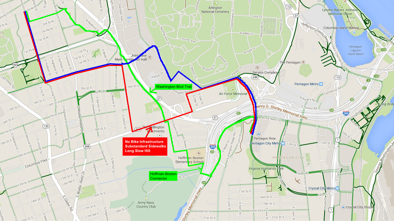
Blue line: The route cyclists could take before the closure.
Red line: The route they must take now.
Green: The possible route with future connections.
Maps by the author on Google Maps base map.
Fort Myer is also important to traveling between DC (using the Memorial Bridge) and central Arlington. Many people currently go through Fort Myer using the 2nd Street and Marshal Drive gates.
The trail on the south side of Arlington Boulevard has a new section which helped provide an alternative, but it is still inferior to riding through the base. There are several major hills between Iwo Jima and the start of the trail, the north side trail west of Pershing Drive is in bad condition.
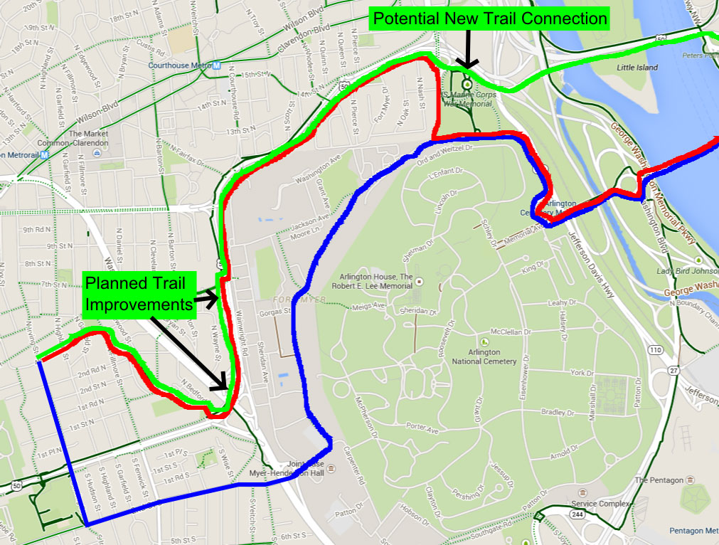
Blue line: The route cyclists could take before the closure.
Red line: The route they must take now.
Green: The possible route with future connections.
Arlington is working on better alternatives
There are plans to build far superior alternate routes, but they are years away, have faced major delays, and are struggling against organized opposition.
The Washington Boulevard Trail would connect the current trail stub beneath Route 50 along Washington Boulevard and up into Towers Park and South Rolfe Street. While this wouldn’t fully solve the problem for people trying to bike to and from Pentagon City, it would eliminate one scary and dangerous part, the long slow climb up Columbia Pike to Courthouse Road.
The Washington Boulevard Trail is facing continued opposition from neighbors concerned about losing trees. The county has re-routed the trail once already to lessen the number of trees it would affect, going so far as to get a new easement from the Navy to avoid several trees.
The county will also follow it’s extremely progressive tree replacement formula, planting many more trees than are cut down, and it has committed to concentrating them in the area of the project. Nonetheless, opponents are calling for a second re-route, placing the trail immediately adjacent to Washington Boulevard and requiring an additional easement from VDOT which is unlikely to happen.
The Hoffman-Boston connector would create a new road, accessible to bicyclists, pedestrians, and emergency vehicles, near Hoffman-Boston Elementary School. The Army Navy Country Club granted Arlington an easement to connect the Arlington View neighborhood off Columbia Pike with the country club’s access road beneath I-395.
When coupled with the Washington Boulevard trail, this would provide a safe, low-stress alternative to get from central Arlington to Pentagon City. The county’s current capital plan has the connector slated for construction in 2023.
The Arlington Boulevard Trail: Arlington has had a project on the books for years to upgrade the Arlington Boulevard Trail from Pershing Drive west to where it currently wraps around to connect to Washington Boulevard. At one time it was slated for construction in 2013, but at this point it doesn’t even have a web page.
Improving this stretch would help those cyclists trying to reach DC via Memorial Bridge, but to really make this connection great, Arlington and VDOT need to work together to fully complete the Arlington Boulevard Trail as envisioned by WABA, including a new connection to the Roosevelt Bridge.
Arlington has little influence over most of the land in this area
The security change at Fort Myer highlights a common issue for Arlington when planning cycling infrastructure: Major portions are outside of the county’s control. The National Park Service controls the Mt. Vernon Trail as well as all of Arlington’s access to the Potomac riverfront. The Pentagon controls access to the trail near the 9-11 Memorial as well as the bridge to LBJ Grove.
The W&OD trail is controlled by the Northern Virginia Parks Association and while Arlington “owns” the Custis Trail, it is located within VDOT’s right-of-way. While Arlington needs to continue working collaboratively with these partners, it also needs to take control of its own cycling destiny by building alternative infrastructure.