Plans envision multimodal “crossroads” at Mt. Vernon Square
Photo by Kim Smith.
DC’s least successful bicycle and transit infrastructure is on 7th and 9th Streets, NW, where drivers constantly occupy the dedicated bus-bike lanes.
That’s one of the problems the DC Office of Planning and DDOT hope to address with a new study of the Mount Vernon Square area and 7th and 9th Streets. Planners also looked at ways to improve the area’s parks, including the square itself and also the four “bow-tie” parks where Massachusetts and New York Avenues intersect 5th and 11th Streets at L and I.
OP established four goals for the project, based on input at their first public meeting held in October. First, the project should achieve multimodal transportation access, with a strong emphasis on cyclist and pedestrian safety. Second, the Mount Vernon Square area should achieve a compelling mix of uses to draw residents and visitors to it rather than simply funneling people through it.
Third, the considerable open space in this quarter should be preserved, yet transformed by creating a flowing series of parks and public spaces. Fourth, OP believes an active partnership between multiple private and public stakeholders will be necessary to achieve a “vibrant economic crossroads” centered on Mt. Vernon Square.
Planners talked about parks like Bryant Park in NYC. They acknowledged that the current spaces are often underutilized, difficult to get to and from due to the surrounding roads, and, because of placement of monuments and sidewalks, it’s tough to pull together enough space for use for activities instead of just passive space. They want to turn these parks into a network of green spaces to tie together the surrounding neighborhoods (Logan, Shaw, Chinatown, Downtown, Mt. Vernon) instead of keeping the neighborhoods apart.
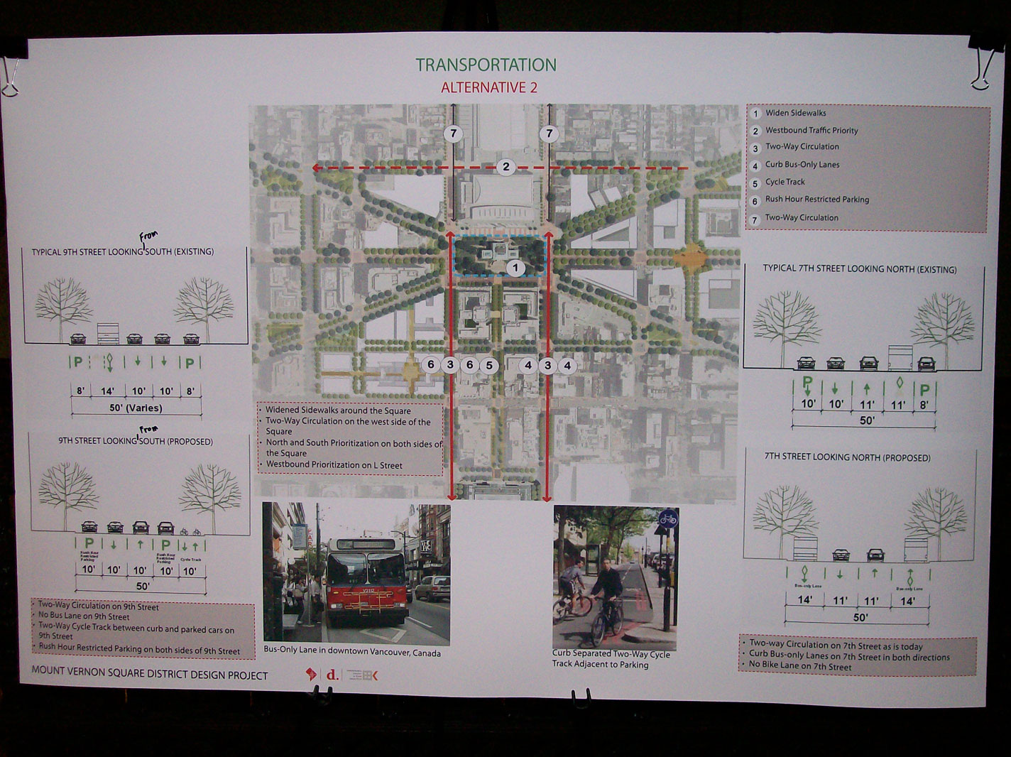
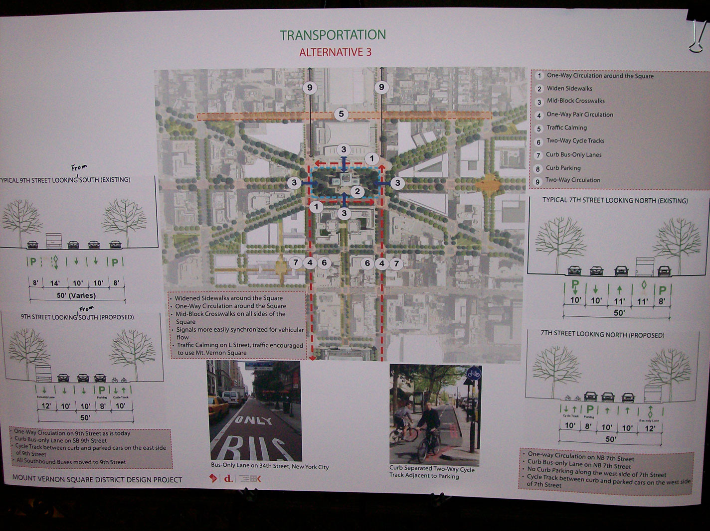
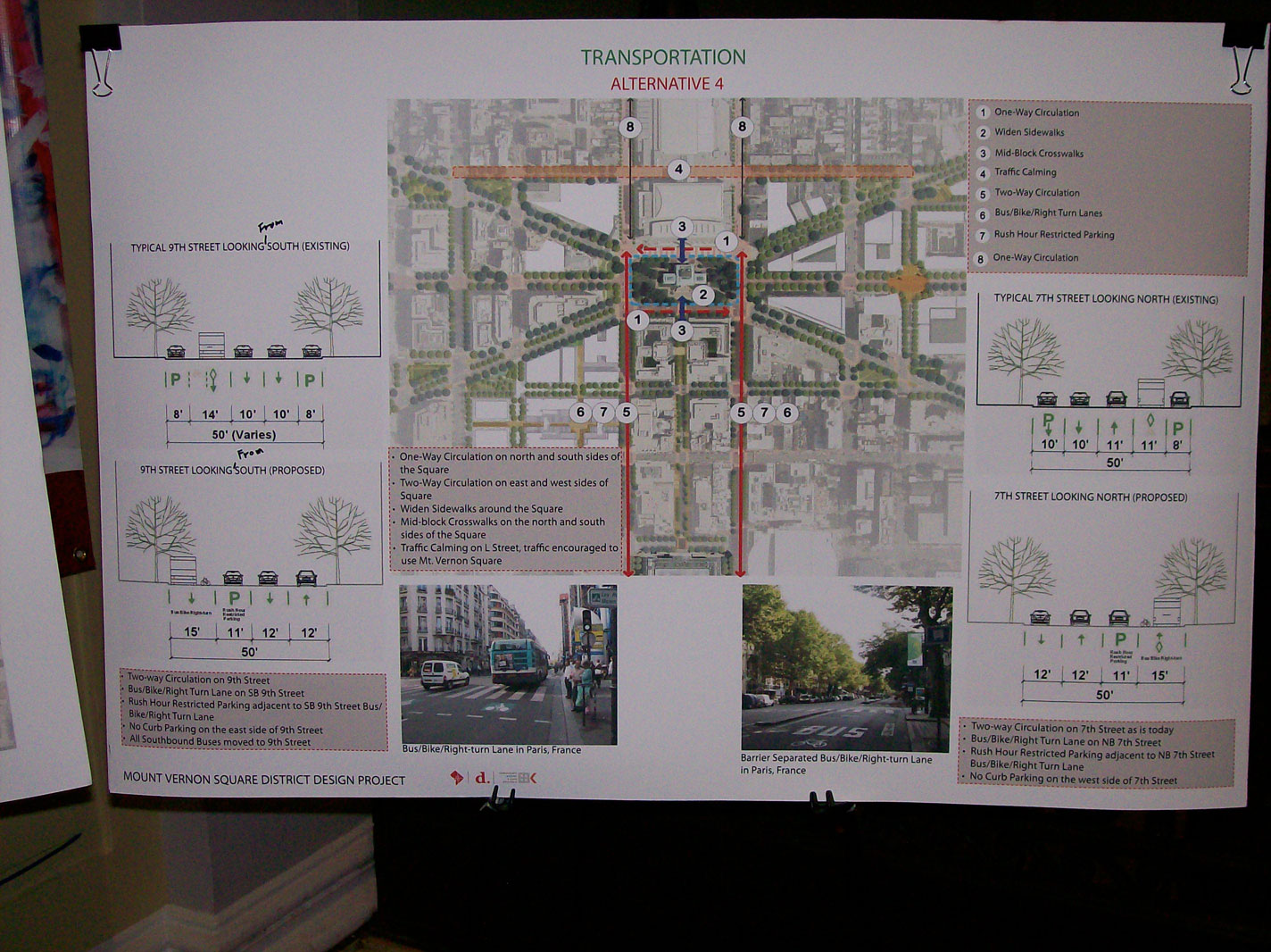
The maps showing possible changes to the road network around the square drew the most attention. Planners created 4 alternatives, along with a list of other options that could be included à la carte with any alternative.
The Office of Planning will be taking comments until January 11, including choosing which alternative they like the best or mixing and matching parts of them. At the next meeting, they hope to present 2 “hybrid” plans that will the most popular choices, and make a final decision among those. Traffic analyses of each alternative will happen between now and then.
- Alternative 1 moves the bus-only lane on 7th street to the curb (eliminating the parking lane), and adds a two-way cycle-track to 9th street. (Diagram)
- Alternative 2 widens the square on all sides (pushing the sidewalks out 12-24 feet) and encourages westbound traffic on New York Ave. to take L Street to avoid the square. It turns 9th Street two-way, adds curbside bus only lanes (north and southbound) to 7th Street, and adds a two-way cycle track to 9th Street. (Diagram)
- Alternative 3 makes traffic one-way around the square (similar to Stanton Park or Lincoln Park on the Hill), widens the square, and adds mid-block crosswalks to the square on the 8th Street and K Street axes. 7th Street becomes one-way northbound, paired with 9th Street as one-way southbound. Traffic is discouraged from cutting through from NY to Mass by using L Street. Both 7th and 9th get two-way cycle tracks and curbside bus lanes. (Diagram)
- Alternative 4 has 7th and 9th Street both two-way, with a curbside bus lane and a bike lane between the bus and traffic, and parking lane between the bike lane and two-way traffic. The north and south sides of the square become one-way (eastbound to the south, westbound to the north). This widens the square, only adds mid-block crosswalks to the 8th Street axis, and discourages cut-through traffic on L Street. (Diagram)
I [Geoff] would personally like to see a combination of elements from 3 and 4: one-way traffic around the square, two-way traffic on 7th and 9th with buses on 7th, and a cycle track on 9th.
In addition, 10th Street will become two-way between New York and Mass Avenues, in anticipation of the road being reopened through the old convention center site and the road becoming two-way through the neighborhood to the north. The sidewalk on the west side of 9th north of the square would be widened to allow for better access to businesses there (current and future business).
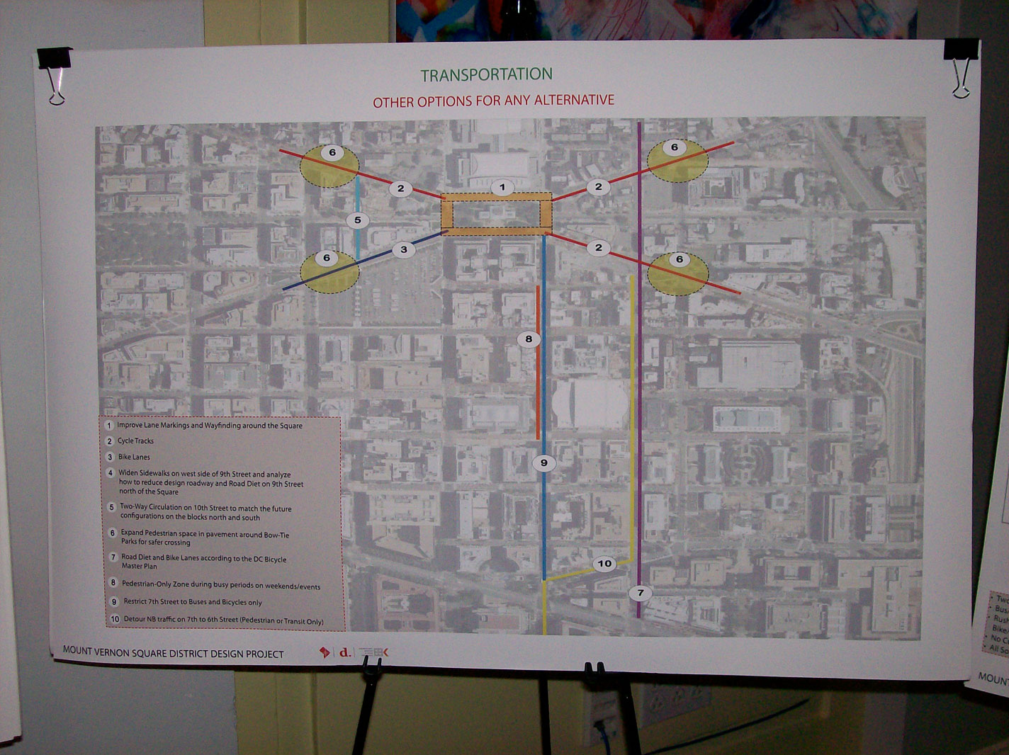
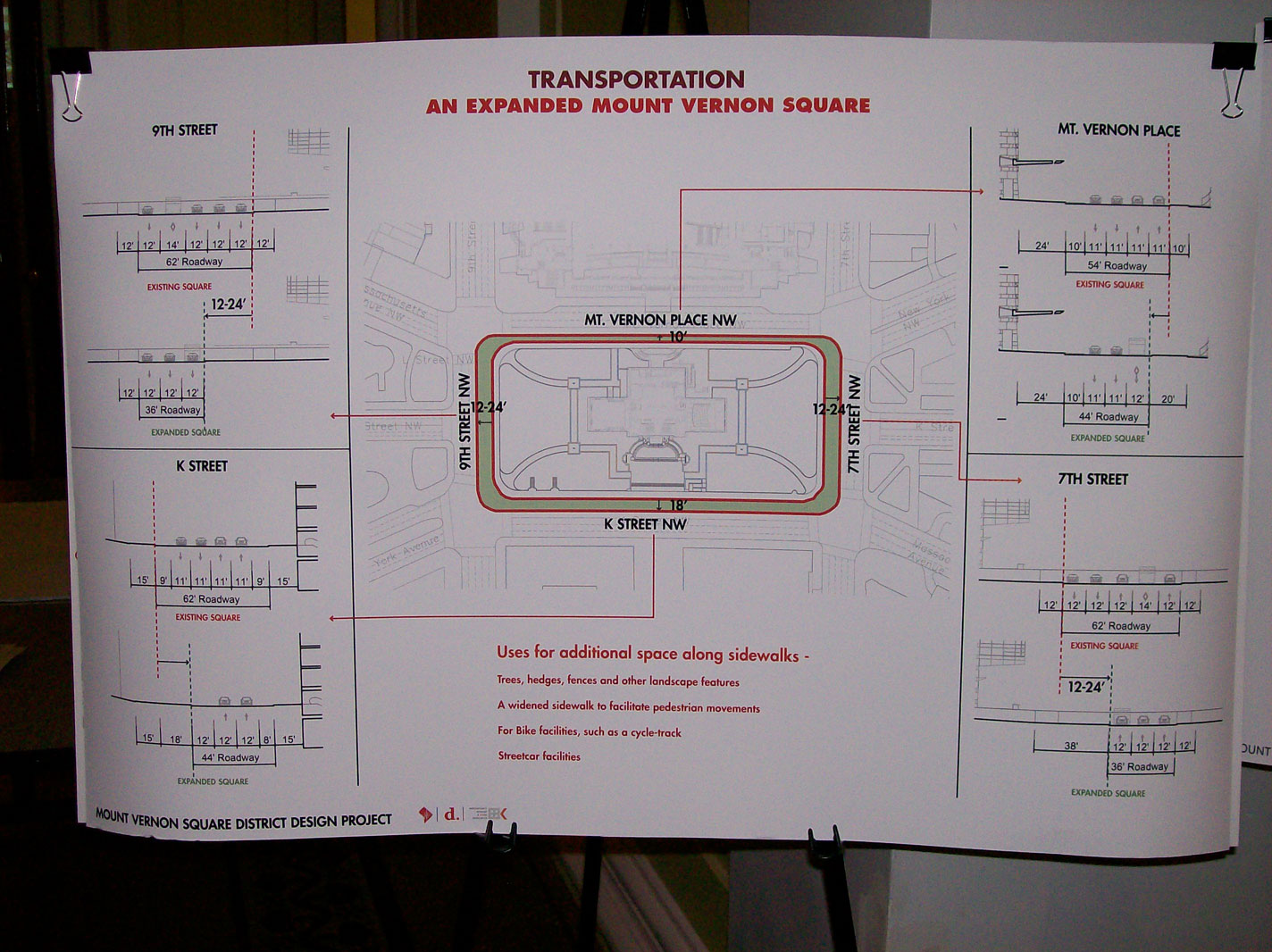
À la carte options (left) and possible widening (right). Click on an image to enlarge.
À la carte options include restricting 7th Street from F to I to pedestrians and bikes on weekends or during big events at the Verizon Center. 6th Street could be narrowed to slow traffic from Pennsylvania Avenue north to Rhode Island Ave. 7th could become bus and bike only from Indiana to Mass, meaning northbound auto traffic would be routed to Indiana Ave and 6th Street.
In addition to cycle tracks on 7th or 9th, they are also under consideration for Massachusetts Avenue on both sides of the square and New York Avenue to the east.
Discussion about the parks included talk of programming the square similar to how the old convention center space is now, with someone in charge of bringing larger-scale but appropriate operations to the square.