The Park Service wants to fix a dangerous spot near Roosevelt Island
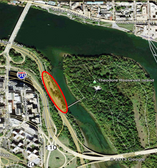
Location of the parking lot. All images from NPS.
The National Park Service is trying to make the Mount Vernon Trail safer as it passes by the parking lot for Roosevelt Island. The agency devised four alternatives, but has already dismissed two, one of which which would have done more to fix the problem than the more conservative remaining ones.
In this area, the trail passes the entrance to the parking lot which drivers use to access Roosevelt Island. There is a lot going on in this area. Pedestrians and cyclists crowd the trail. Cars enter and exit the parking lot. Hikers cross to get to the Potomac Heritage Trail and Roosevelt Island.
To make matters worse, the trail crosses the parking lot with two sharp 90° turns. ADA ramps and at least one tree extend into the trail space, and the trail through the area doesn’t even meet NPS’ 9-foot trail width standard. As a result, there have been numerous crashes in the area, some involving cars, others between cyclists and pedestrians.
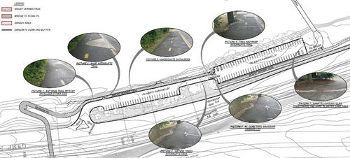
Current layout of the parking lot and trail.
Besides improving safety, NPS wants to install a water fountain, more and better bike racks (since bicycles are not allowed on Roosevelt Island), and better signage.
Alternative 1 keeps the trail separated from the parking lot by a curb and widens it to 9 feet, with a 2-foot grass shoulder on one side and a 2-foot paved shoulder on the other. It also shifts the parking lot crossing to a gentler angle.

Alternative 1.
This makes it easier to navigate, but harder for cyclists to see oncoming traffic. It also elevates the trail crossing on a speed table (a wide speed bump) which forces cars to slow as they cross the trail. It would also remove an existing curb cut from the west end of the trail that cyclists currently use to go from the trail into the parking lot.
Alternative 2 lowers the trail to parking lot level, separating it from the parking lot by only a stripe of paint, similar to a bike lane. It also widens the trail to 9’ and provides a separate 3’-wide pedestrian trail. Like Alternative 1, it changes the angle of the crossing but the crossing would be at parking lot level, rather than on a speed table.

Alternative 2.
Alternatives 1 and 2 are the options NPS officials are still considering. They also developed a 3rd and 4th, but discarded them.
Alternative 3 was the most aggressive proposal. It separated cars from cyclists and pedestrians entirely by eliminating the parking lot and trail crossing. It shifted the parking lot closer to the parkway and rerouted the trail to be entirely on one side of the lot. NPS dismissed this option because it would have eliminated 11 parking spaces.
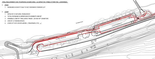
Alternative 3.
Alternative 4 proposed moving the trail to cross the parking lot entrance and then run between the parking lot and the parkway. This would have been less safe due to the speed of traffic entering the parking lot from the parkway, and the bad sight lines at that spot.
What is best?
The reason many cyclists use the parking lot is to avoid congestion between bikes and pedestrians. Alternative 1 largely takes that option away, while providing only 1 foot of additional width to address the problem. The possibility in alternative 2 to separate bikes and pedestrians onto different trails is a nice step.
However, moving the trail to parking lot level could increase conflict between bikes and cars, as cars could back out of parking spaces directly onto the trail. The speed table from Alternative 1 seems to be a better approach.
It’s too bad NPS didn’t consider widening the trail beyond the agency’s 9-foot minimum trail standard, despite the huge amount of bicycle and pedestrian congestion here. Nationwide, a 10’ minimum is more common, and Arlington prefers 12 feet.
Also, Alternative 3 was the the only alternative that would fully separate cyclists and pedestrians from car traffic, but it has already been discarded.
To review the full details of the project, or to submit comments, see the project website. You can submit comments through April 22nd.