Bus rapid transit, light rail, and a longer Yellow Line are choices for Route 1
Better transit could one day come to Virginia’s Route 1 between the Beltway and Woodbridge. A transit study looked at transit options and narrowed down the choices to curbside or median Bus Rapid Transit (BRT), light rail, or a hybrid of BRT and extending Metro’s Yellow Line.
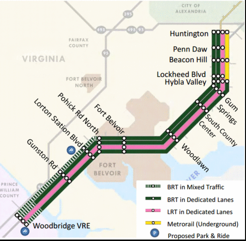
Transit alternatives for Route 1. Map from the study.
The study presents a wealth of data and a thorough analysis, but raises key questions, including what speed limit is appropriate for a more transit-oriented Route 1. A new high-capacity transit system would transform the corridor, but there would be challenges to ensure a safe pedestrian and bicycle environment and preserve affordable housing.
Transit alternatives
The study considered 8 transit options before eliminating streetcar, enhanced bus, express bus, local bus, a Yellow Line extension all the way to Woodbridge, and monorail. The 4 alternatives that remain for further study are:
- Curbside Bus Rapid Transit (including a stretch in mixed traffic from Pohick Road to Woodbridge)
- Median Bus Rapid Transit (with a shorter mixed traffic section in Prince William County to Woodbridge)
- Median Light Rail Transit
- A Metrorail-BRT Hybrid, extending the Yellow Line to Hybla Valley and then switching to BRT.
The evaluation considered ridership, estimated capital, operations and maintenance costs, cost per rider, and land use. All alternatives terminate at Huntington Metro, both to simplify the analysis and because Alexandria has raised concerns about extending transit up Route 1 into the city.
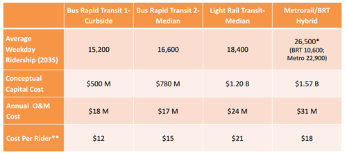
Ridership and preliminary costs. Chart from the study.
The study looked at 3 land use scenarios:
- A baseline forecast for 2035 from the regional Council of Governments model;
- 25% more growth based on what a BRT or LRT line would likely generate;
- 169% more which is necessary to support Metrorail service.
Conceptual illustrations for one development node, Beacon Hill, show how much development would correspond with each level of transit.
The Beacon Hill area now.
Scenario 1: 2035 COG projection.
Scenario 2: Growth with BRT or LRT.
Scenario 3: Metro-supporting density.
For the road itself, the study rejects widening Route 1 to four lanes in each direction, as well as converting existing lanes to transit-only. That leaves a recommendation for three general lanes in each direction as well as transit in a separate right-of-way.
What transit do you think should go in this corridor? In part 2, we’ll talk about how to create a sense of place and what this plan means for housing affordability.
You can also give the study team comments through a survey, but because the questions are limited, either add explanatory comments or make more extended comments on their share-your-ideas form.