Turn Richmond Highway back into a string of distinct places
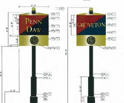
Photo by DEV58 on Flickr.
The 9-mile stretch of Richmond Highway between the Beltway and Fairfax County Parkway traverses an extraordinarily diverse swath of Fairfax County. There are many informal names that locals use to describe the various sections of the corridor, such as Penn Daw, Beacon Hill, Groveton, Hybla Valley, Gum Springs, Mount Zephyr, Woodlawn, and Accotink.
While some of these names go back hundreds of years, their identities have largely become lost amidst the corridor’s swirl of suburban sprawl. The Postal Service further obscures these identities by using mailing addresses of “Alexandria, VA,” despite their location well outside the City of Alexandria’s boundaries.
A revitalizing Richmond Highway will benefit from people seeing a set of individual, distinct places instead of one undifferentiated stretch of sprawl. Arlington achieved this along the Rosslyn-Ballston corridor, but had Metro stations to help. Can Fairfax achieve this without Metro?
The corridor’s north end is directly adjacent to Old Town Alexandria and includes high-rise office, apartment, and condo buildings, several hotels and the Huntington Metro station. The next segment of the corridor largely consists of large-scale retail centers anchored by national big-box tenants.
Richmond Highway then narrows and becomes an uneven amalgamation of low-density commercial, residential, and retail uses, culminating with the historic area around Woodlawn plantation and the rough mix of commercial uses just outside Fort Belvoir.
Revitalization depends on making many places again
Photo by DEV58 on Flickr.
Efforts to revitalize Richmond Highway emphasize remaking the corridor as “pearls on a string,” with several central nodes along the way, instead of a homogenous corridor. Recent changes to the Comprehensive Plan around several key nodes have increased the allowable uses, heights, and densities to open the door to higher scaled, mixed-use developments.
Fairfax is installing a series of gateway and wayfinding signs along the corridor. When these signs are installed later this year, travelers will be more aware that they are arriving in Penn Daw, Groveton, Hybla Valley, and other locations.
Will these attempts to restore local identities actually get people to refer to them as anything other than “Richmond Highway,” “the Fairfax section of Alexandria,” or the “Alexandria section of Fairfax”? The best example of this effect in the region is the Rosslyn-Ballston corridor, where a generic Wilson Boulevard differentiated into distinct names like Clarendon, Virginia Square, and Ballston.
The key ingredient in this case was the Metro, which used these names on stations. It restored historic names and created some new ones that hadn’t existed before.
Can Penn Daw become a distinct place?
As Richmond Highway evolves into a string of urban nodes, it is possible that people could eventually think of it as several distinct places. The best chance is at Penn Daw, the historical name of the intersection of Richmond Highway with North and South Kings Highways.
Recent and ongoing changes to the Fairfax County Comprehensive Plan envision about 2,000 multifamily housing units with ground level retail around this intersection, giving it the scale and density of a distinct urban place.
It will be interesting to see what names developers of mixed-use projects in Penn Daw choose. The buildings themselves may shape what future residents call the area. The preliminary name of one of the proposed projects is “The Grande at Huntington,” suggesting that the developer wants to trade on the site’s proximity to the Metro station located more than ½ mile away.
Given this, Penn Daw might never be considered a distinct place apart from Huntington, until and unless the Yellow Line gets an extension that includes a Penn Daw Metro station. Barring that, Fairfax will have to work to create a sense of place for each community.