Then and Now: 470 Louisiana Avenue
Shorpy highlighted this circa 1925 photograph of buildings at 470 Louisiana Avenue. What’s at 470 Louisiana today?
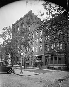


Left: 470 Louisiana Avenue circa 1925. Photo from the National Photo Company Collection.
Top right: Today’s 470 Louisiana Avenue. Bottom right: The Moultrie Courthouse at 500 Indiana Ave, NW. Images from Google Street View. Click any image to enlarge.
As it turns out, Louisiana Avenue isn’t in the same place it was in the 1920s. Back then, Louisiana Avenue stretched from 12th and Constitution to what’s now Judiciary Square at D Street between 4th and 5th. Indiana Avenue then mirrored it, heading back southeast toward the Capitol. Today, that road is gone west of the Navy Memorial, replaced by the superblocks of the Federal Triangle.
The remaining portion from 7th to 5th is now called Indiana Avenue, and the old Indiana Avenue mostly disappeared into the giant trench of the Center Leg Freeway except for a few small stub remnants. Louisiana Avenue today is a totally different road, going from 2nd and Constitution NW to Columbus Circle at Union Station around 1st and E NE.
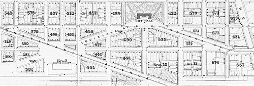
1872 map of what’s now the Federal Triangle and Judiciary Square areas. 11th Street is on the west, New Jersey Avenue on the east, Constitution Avenue on the south and and E Street on the north. Image from NOAA Office of Coast Survey Historical Map & Chart Project. Click to enlarge.
There’s a 470 Louisiana Avenue, but in Northeast, and it’s one of the Senate parking lots adjacent to Columbus Circle that mar the walk between Union Station and the Capitol. As far as I can tell, the area of the historic 470 Louisiana Avenue is now DC’s Moultrie Courthouse, 500 Indiana Avenue NW.