Better access to RI Ave Metro would help communities
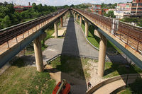
Photo by robin.elaine on Flickr.
Despite being one of the original stations in the Metro system, the Rhode Island Avenue-Brentwood station hasn’t reached the potential of so many others because of a lack of connections into the nearby communities. Simply improving pedestrian access to the station will invigorate otherwise disconnected neighborhoods.
In 1976, designers created a park and ride station, with pedestrians and pedestrian connections to surrounding neighborhoods as an afterthought. Although it straddles 4 neighborhoods (Brentwood, Edgewood, Eckington, and Brookland), the station barely connects with 2, and it stands nearly 50 feet above Rhode Island Avenue.
The high elevation and a lack of neighborhood connections hinders the neighborhoods around the station from developing into the vibrant communities they could be.
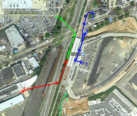
Access points to the Rhode Island Avenue Metro. Image modified from Google Maps.
Today, there are only 3 ways of accessing the station:
- The bus bays next to the former parking lot (labeled 1 on the map)
- A winding pedestrian bridge (labeled 2)
- A (temporarily closed) four-story staircase from Rhode Island Avenue (labeled 3)
Plans are in the works for an additional pedestrian and bicycle bridge (labeled 4), which will connect the station with the Rhode Island Avenue Center mall and the Metropolitan Branch Trail. Although this will improve station access, another connection is needed for the areas southwest of the station.
Riders from nearby Eckington must trek up Rhode Island Avenue, under an overpass on a narrow sidewalk where cars speed by, then go up the ramp or stairs to reach the station. Even for residents closest to the station, the circuitous walk can take up to 15 minutes and makes rail a less-appealing option for riders.
A ramp should be built from the station, across the CSX tracks and down W Street to better connect the station with Eckington (labeled 5 on the map). This will enable residents to access the station more readily and will lay the groundwork for future improvements along 5th Street NE.
In its vision for the Rhode Island Avenue corridor, the DC Office of Planning suggests turning the area around the rail overpass and 5th Street into a mixed-use district, containing shops, offices, and new residential structures. The report also calls for a new connection to the station, running along the 600 block of W Street NE (which is currently used as an alley for nearby warehouses) toward the station (labeled
5 on the map).
Making another pedestrian connection to the station would create a sense of neighborhood cohesiveness that does not currently exist, and help surrounding neighborhoods grow and prosper.