Can the CCT bridge Wisconsin Ave in Bethesda?
The design of the Purple Line might mean displacing the Capital Crescent Trail from its Bethesda tunnel. Some say that an at-grade crossing of Wisconsin Avenue will be too dangerous for cyclists and pedestrians. But are there any good alternatives?
I think that many hope that if only we make a strong commitment, bring creative imagination and bring professional expertise to the problem, then we can find an attractive alternate way. Maybe something that looks like this:
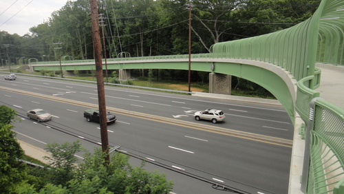
Rock Creek Trail bridge over Viers Mill Road.
Image from the National Transportation Enhancements Clearinghouse.
But the difficult part is the array of constraints presented by the crowded, urban space in Bethesda at Wisconsin Avenue.
Bridging the gap
A trail bridge with long ramps on either end will not fit into the space available along Bethesda Avenue and Willow Street without blocking critical business access and parking structure driveway entrances. And that’s not feasible unless the county is willing to purchase the affected properties.
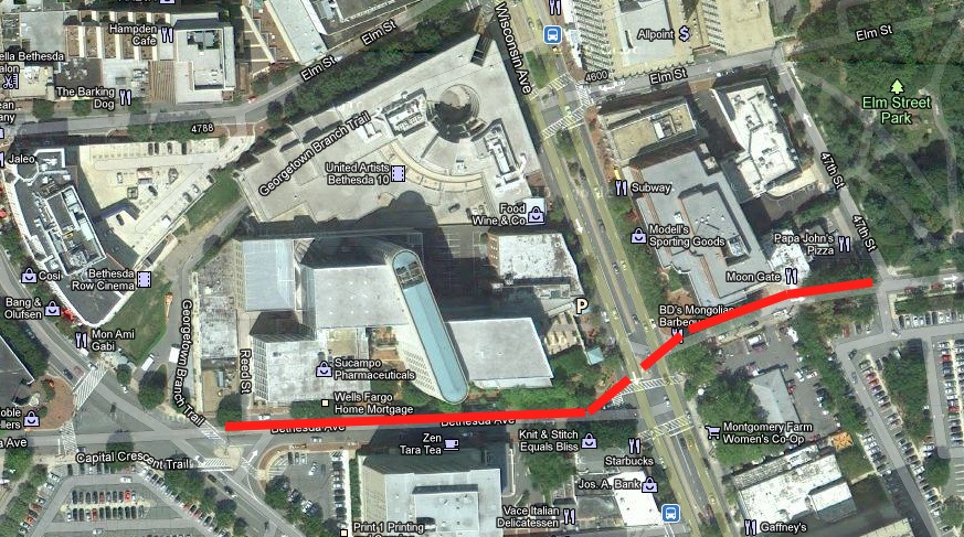
A conceptual bridge alignment. Click to enlarge.
The aerial map above shows the approximate length of the ramps for a trail bridge over Wisconsin Avenue that would be needed to meet ADA requirements.
A ramp up Bethesda Avenue must elevate the trail by approx. 18 feet above Wisconsin Avenue to allow clearance for traffic below and space for bridge deck supporting structure. Bethesda Avenue rises from Woodmont Avenue to Wisconsin Avenue and the bridge ramp must “chase the grade”, adding another approx. 10′ to the total elevation gain needed on the ramp. If we assume a 5% ramp grade, then we will need a ramp that is 560 feet long on Bethesda Avenue.
We can shorten the ramp a little and still be ADA compliant by going up to a 7% grade that has flats at regular intervals. But even so the ramp will still be too long to avoid blocking driveways on either side of Bethesda Avenue.
One driveway on the north side of Bethesda Ave. Image from Google Street View.
Any ramp over several hundred feet long on Bethesda Avenue will block important driveway entrances, whether on the north or south side of the street. The problem is much the same for a ramp on the other side of Wisconsin Avenue at Willow Street. A ramp on Willow Street could be shorter, maybe a little less than 400′, since it would not be “chasing the grade”. But it would still be much too long to avoid blocking critical driveway entrances on either side of Willow Street.
Switchback ramps or spiral ramps are shorter than linear ramps, but their footprints are at least twice as wide — there is no place that can accommodate the wide footprint of either a switchback or spiral in this area. And the question arises: “How many trail users will want to use such long, steep ramps if they can cross at-grade at a light?”
Can we find another location for the bridge and ramps?
If we explore other locations for a Wisconsin Avenue bridge crossing, we will get the same result: long ramps will create unacceptible blockages of driveways and business entrances. Elevated crossings at Elm Street, Miller Avenue, or Leland Street will create unacceptible blockages by the ramps on both sides of Wisconsin Avenue, and the routing of the trail on the east side of Wisconsin Avenue becomes very problematic for these alternate crossing locations. The “chasing the grade” problem is even more severe on Elm Street than it is on Bethesda Avenue.
An alternate approach is to consider “going aerial” for a longer distance than just on a bridge, so the ramps can be some distance away from the constraints near Wisconsin Ave. One obvious areal route would be to have a ramp at the Bethesda Trailhead adjacent to Ourisman Honda, go on aerial structure across the Bethesda Ave./Woodmont Ave. intersection, up Bethesda Ave., across Wisconsin Ave., and up Willow Street and then come down another ramp at Elm Street Park.
But the ramp at the Bethesda Trailhead would have to begin about 400′ south of Bethesda Avenue and very near the trail rest plaza to gain the elevation needed to clear Bethesda Avenue. The width of the ramp, at least 14′, would likely preclude also having a full width surface trail alongside the ramp. The local trail access to Bethesda Row along the trail right-of-way would be greatly compromised.
A long aerial structure would be very visually intrusive to the rest stop, Bethesda Row, the future Woodmont Plaza, all of Bethesda Avenue and Willow Street, and to Elm Street Park. Access to the Bethesda street grid and downtown destinations would be limited. If the only goal is to separate trail users from the Bethesda street grid, it might be better to reroute the CCT to completely bypass downtown Bethesda. But these approaches will not serve the many trail users who want good access to downtown Bethesda destinations.
Would a trail tunnel under Wisconsin Avenue fit any better?
Yes, a new trail tunnel would have much less impact on the Bethesda streetscape than would any trail bridge.
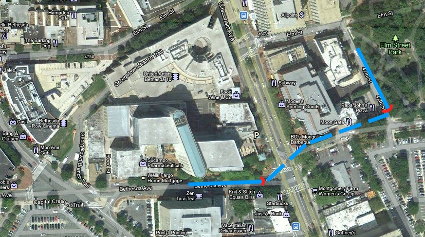
Conceptual tunnel alignment in Bethesda. Click to enlarge.
The conceptual sketch above shows the approximate location of portals (shown as red markers) into a new tunnel under Wisconsin Avenue. The aproximate lengths of the down ramps, or cuts, needed to take the trail elevation down to enter the tunnel at the portals is also shown.
Note that the down ramp, or cut, needed on Bethesda Avenue is less than half the length that would be needed for an up ramp to a bridge. There are two reasons why this is so. First, the existing elevation change along Bethesda Avenue helps for a down ramp, instead of forcing us to “chase the grade” for an up ramp. Second, we don’t need as much elevation difference between the street grade and the top of the tunnel as we needed for clearance for the bridge (only maybe 12′ vs. 16′). I estimate a down ramp as little as 200′ long might work on the Bethesda Avenue end of the tunnel. That could just fit on the north side of Bethesda Avenue without blocking any existing driveways.
The down ramp on the Willow Avenue end of the tunnel would be a little longer, since there is no help from an existing grade on that side, and it would be too long to fit along Willow Avenue without blocking a driveway. The most feasible location for that down ramp would be as shown in the sketch, along the east side of 47th Street at Elm Street Park. A ramp should ideally continue east along the north side of Willow Street at the Park to avoid the trail turn at the tunnel portal, but I estimate that block of Willow Street is too short for the down ramp to fit.
The tunnel path shown in the drawing is only notional and can shift slightly to better suite construction conditions, but I think any “cut and cover” tunnel will need at least one bend in it to avoid buildings. A deep bore tunnel could be straighter if it goes under buildings, but it would be prohibitively expensive.
A tunnel can fit. Does that make it good?
This tunnel will fit into the Bethesda streetscape much better than will any elevated structure. The obstructive ramps would be much shorter, and the visual intrusion would also be minimal. But the tunnel will not be attractive to many trail users, and the cost will be high.
This is a long tunnel, and will not resemble an underpass which has a much more open feeling. The tunnel will not be as wide or high as is the existing trail tunnel under the Air-Rights Building. It will have curves and turns that will limit the sight lines to be much shorter than in the existing trail tunnel.
Trail users will not be able to see what is ahead of them in the tunnel when they enter. The perception and the reality of safety will be much lower than we have experienced in the tunnel under the Air-Rights Building. Many trail users (including me) will likely prefer to stay on an enhanced surface route.
The existance of this tunnel will preclude having a full width trail on the surface route. The tunnel down ramp on Bethesda Avenue will need at least a 14′ width, and that will take most of the width available so that only a minimal width sidewalk (6-8′) can remain alongside for the surface route. Similarly a 14′ wide down ramp adjacent to Elm Street Park will take the “easy” space between 47th Street and Elm Steet Park. Taking another 14′+ to also have a full width surface trail will have an unacceptible impact on the park. Trail users wanting to take the surface route instead of using the tunnel will be severely impacted by the existance of the tunnel.
Construction of the cut-and-cover tunnel will require moving all utilities along its path — and there will be many of them along these streets. The disruption to traffic on Wisconsin Avenue during construction will be considerable, and construction incentives to minimize the time of this disruption will impact cost. I do not have the experience needed to estimate the tunnel costs, but it is a safe bet it will be high.
I believe a new trail tunnel under Bethesda Avenue will compare very poorly with the tunnel design that has been proposed for the trail with the Purple Line under the Air-Rights Building. It is a bad idea, largely because it will obstruct a full width, off-road trail on the surface route that many of us would choose to use instead of the tunnel.
What is the best way forward?
WABA has stated its position on the way forward in its Quick Release blog.
“…as advocates for the best possible trail and crossing, WABA asks that the county take steps to evaluate the importance of a grade-separated crossing, account for the importance of grade-separation to trail usage and safety by including an alternative grade-separated option, and clearly define the proposed enhancements that would be included in the on-street option that would make it more than a fallback cost-savings at the expense of trail users and to the detriment of the project.”
My opinion about the best way forward differs from WABA’s.
I think there is little value in exploring an alternative grade-separated option much further. The many constraints of the Bethesda urban design space will make a new trail bridge not realistically feasible. The best likely new trail tunnel will be too unattractive to many trail users and will physically obstruct our best surface trail route.
Continuing to pursue an alternative grade-separated crossing will only take us to more dead ends. We should instead focus on getting the strongest possible commitment from the County that if a decision is taken to not keep the CCT in the tunnel under the Air-Rights Building, then the features recommended for the enhanced surface route in the Planning Board letter will be implemented. The most important of these enhancements is to provide a protected Wisconsin Avenue crosswalk by restricting motor vehicle turning movements.
With the commitment of the county, we can design a safe, direct connection for the CCT that is on-street. We should push for the best design possible as we focus on building a better trail for the future.