“Wedges and Corridors” still shapes Montgomery
Wedges and Corridors is the name of Montgomery County’s governing master plan. While it was updated in 1992, the basic framework is the same. Revered by many, forgotten by few who were active during that time, the General Plan, as it is also known, has stood the test of time.
It is important to put this landmark Wedges & Corridors Plan in context. It was developed in the post World War II period — in the late ‘50s and early ‘60s. That was two generations ago, and a lot, of course, has changed.
Wedges and Corridors was a simple, yet pioneering concept. Truly a great plan in the history of planned growth in this and any other country. The planners and others who worked on it should have a place in the urban history books. The plan covers both Montgomery and Prince George’s counties, both of which make up the Maryland National Capital Park and Planning Commission.
While the majority of the folks in the county have no knowledge of the General Plan, it defines what the county is today and still shapes the future.
The big ideas from the plan revolve around the concepts of cities laid out along corridors and wedges of different land uses between those corridors. Note that the “corridors” is plural, referring to the single one the plan identified in Montgomery County and the others in Prince George’s County. So as it applies to MoCo, there is one corridor identified, and that is I-270.
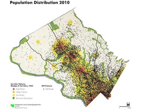
The 2010 population is superimposed upon the corridor cities plan from the 1960’s Wedges & Corridors Plan. It shows we grew just as the planners thought we would 45 plus years ago.
Germantown is a corridor city with a population of just over 86,000.This is the largest defined place in the county, 25,000 greater than Silver Spring at 71,500 and Bethesda at 69,000. Yet, where is the downtown in Germantown? Compare the block or two around the Black Rock Center to the downtowns in Silver Spring and Bethesda. Clearly, the density of that corridor city is different than the other two. Perhaps centralizing more of the density could have created a walkable pedestrian-oriented downtown for Germantown.
Transportation:
MoCo has plenty of roads. However, we have too many cul-de-sacs or roads that just end. We lack a larger grid pattern that might mimic an urban setting, but at a much larger scale. And this will not change, meaning big challenges in trying to create an effective transit system that serves a low density, unconnected string of corridor cities, centered on one corridor: I-270.
Check out this graphic showing all the roads in MoCo. Whenever I show this in a presentation, I get the same reaction, that people are not aware we have this many roads. I am looking into trying to graphically show how many miles of roads we have and what percentage of them actually carry the bulk of the traffic. The results may be interesting.
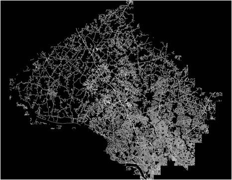
The contrast between the black and white highlighting the roads of MoCo really points out the disparity between the roads we have built, and the roads we use to get places. Looking at the patchwork of roads would lead someone to think there should be no traffic problem.
And what about the transit the plan called for? We got the Red Line. Takoma Park, Bethesda and Silver Spring realized the potential of the rail stops. But what about Forest Glen and the Grosvenor metro stops? Did we realize the vision of the Plan at major transportation infrastructure investments? There are townhomes being built within walking distance of the Grosvenor metro stop, yet the mid-rise, multi- unit buildings are farther away
Not all transit stops are equal in terms of the density around them and that is how it should be. Yet perhaps the investment could have been better utilized in a few locations.
It has taken 40 years and a zoning change to finally realize the potential of the White Flint Metro stop. We are creating more density and housing at Twinbrook and it is something to consider as we move forward with White Flint II and Glenmont plans.
What does Wedges & Corridors mean for the future? Given the projections, the resulting landscape of 45 years of Wedges and Corridors, and the fact we built what was planned for, what are the implications for the future of the County?
It is interesting to consider where the plan predicted we would be today, and to consider the next 40 to 50 years of the plan.
Predictions:
The General Plan was surprisingly accurate in predicting job and population growth in MoCo. (It was less accurate for Prince George’s, where the population there was anticipated to be larger than MoCo’s.) The MoCo population was forecast to be 995,000 in the year 2000. The actual population that year was 873,346, about 122,000 fewer, or 14 percent less than predicted. By 2010, the Census puts us at 971,777 residents.
The plan predicted there would be 301,515 households by the year 2000, while in actuality we had 323,400, a difference of seven percent, again pretty accurate for a 40+ year projection. By 2010 that number grew to 360,500, an 11.5-percent increase over the 2000 number.
The job count is the reverse. The plan projected we would have 335,000 jobs in the county in 2000.Our actual job count then stood at 474,300, about 41 percent more than the predicted total. By 2010, the job total reached about 506,000.
So, if the plan was close on predicting the population and number of households, how did it miss the mark on the number of jobs in the county? This is an easy answer. Keep in mind the era in which plan authors made these predictions — within 15 years of the end of the World War II.
Couples married and had kids. Women stayed home while their husbands went to work. The plan’s founders could never have imagined the boom in the number of women in the workplace and the advent of the DINK household (double income no kids). In fact, today we see only 20+ percent of households forming the “traditional” family of two parents with kids, and we have about an equal percentage of households where one of the parents is staying at home. Add to this the explosion of single-parent households, and it is easy to understand the inaccuracy in the job predictions.
If the demographers of the late ‘50s and early ‘60s had factored in the two-working-parent trend starting in the late ‘70s and beyond, they would have been almost dead accurate on the job count.
Pattern of Growth:
The plan called for a series of cities along the corridor. The idea was to centralize the bulk of the growth in smaller urban places, connected by roads and transit, preserving land for agriculture and open space. Clearly, strategic places of higher density were viewed as the way to preserve large parts of the county and, in fact, MoCo was planned to have urban places. The plan authors did not envision that MoCo would be a wholly suburban place.
Overlaying the 2010 population distribution over that 1960s plan map shows we pretty much grew as the plan called for. But while we grew as the plan authors had envisioned, we lag behind on the connections. Today, there are few options for moving north to south or east to west, hence the daily traffic congestion we have just measured in our latest biennial mobility assessment. (And why I choose to live a four-minute bike ride from work.)