Changes mean more Purple Line and trail grade-separation
Maryland’s MTA is removing the only grade-crossing between Silver Spring and Bethesda in its plans for the Purple Line. This will improve the experience of trail users on the adjacent Capital Crescent Trail and could improve reliability of the light rail line.
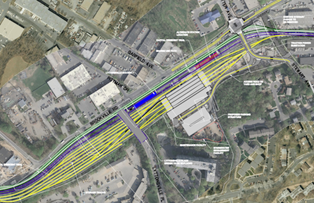
Revised MTA plans for the Lyttonsville area. Click for full map.
Between Silver Spring and Bethesda, the proposed Purple Line will run on an abandoned railroad line. This line has been a bicycle/pedestrian trail for some time, and an improved trail will be included as part of the Purple Line project.
Lyttonsville is an industrial and residential neighborhood near Silver Spring. The area is located north of East-West Highway, between the CSX tracks (MARC Brunswick Line) and Rock Creek. Here, the Purple Line diverges from the active CSX right-of-way to run on the abandoned Georgetown Branch.
The MTA briefed local residents on the new plans at a neighborhood work group meeting last week. Some significant changes have been made to plans in the area. The primary difference is that the future CCT and the Purple Line work yard are flipped in their positions. Now, the CCT is proposed to run along the north side of the Purple Line transit/trail corridor from Rock Creek to the CSX corridor.
One of the major benefits of the Purple Line to trail users will be the inclusion of grade separation at all intersections. Currently, cyclists have to cross traffic 3 intersections and one driveway between Bethesda and the eastern end of the trail in Lyttonsville. Plans had already included adding grade separations at Connecticut Avenue and Jones Mill Road.
With the proposed bridge over the tracks for Stewart Avenue and the closure of the driveway, cyclists and pedestrians will be able to cycle from the Silver Spring Transit Center to Woodmont Avenue in Bethesda without crossing a street.
Other changes are described below:
At Rock Creek, the CCT remains on the north side of the light rail tracks. The prior plans called for the CCT to switch from the north to the south side of the tracks at the Rock Creek trail bridge. The new plan holds the trail on the north side. The trail bridge is simpler since it does not have to twist under the Purple Line bridge.
The access ramp from the CCT down to the Rock Creek Trail would be like before, except that it would be built on the north side of the berm. This access ramp is still under discussion between MTA and M-NCPPC. There are concerns about cost and the impact on the trees on the side of the berm, and a decision could be taken to just continue to use the existing connection on Susanna Lane.
At Grubb Road, a new bridge will carry the access path across the Purple Line tracks to the CCT on the north side. The drawings show a long switchback ramp to provide the elevation needed for the new access bridge. But the access path is roughly along the same alignment as the old Brookville Road bridge that crossed over the B&O tracks here long ago.
The railbed elevation is already well below the elevation the access path has now, and I believe the extent of the switchback ramp shown in the drawing is grossly overstated. When I asked Purple Line project manager Mike Madden about this, he indicated the ramp in the drawing was only conceptual and was not based on any elevation measurements, so it is likely overstated in the drawing.
Along Brookville Road, MTA is proposing an access trail paralleling the main trail. The drawing shows two trails alongside each other along the south side of Brookville Road. The main CCT is the wider trail (to be 12 feet wide) that is next to the Purple Line tracks. It goes under the Lyttonsville Place bridge and under the relocated Stewart Avenue bridge.
The access trail is the narrower trail (to be 8′ wide) that is adjacent to Brookville Road and between Brookville Road and the main CCT. It serves as a Brookville Road sidewalk and also gives access to the main CCT between the Lyttonsville Place and Stewart Ave. bridges. The access trail crosses Lyttonsville Place and Stewart Avenue at-grade at the north end of the bridges.
At the Lyttonsville station, the CCT is on the north side. Under the old plan, the Purple Line tracks and station were on the south side of the rail yard, and the trail was on the south side adjacent to the industrial lots. Under the revised proposal, the trail and Purple Line have been moved to the north side, closer to Brookville road.
Additionally, MTA is considering moving the transit station location further east, closer to Stewart Ave. This would place the station closer to the entrance to the Walter Reed Annex, the area’s largest employer.
A bridge at Stewart Avenue, will be constructed. Part of Stewart Avenue will be shifted to line up with the main entrance to the Walter Reed Annex and to have Stewart Avenue cross over the CCT and the Purple Line on a new bridge. The old plan had both the trail and transit crossing Stewart Avenue at-grade. This change would remove the only at-grade roadway crossing on the CCT and Purple Line between Bethesda and Silver Spring, making the rebuilt trail 100% grade separated.
A relocated trail bridge over the CSX tracks. The CCT would cross over the CSX tracks on a new bridge similar to the old plan, but the bridge would be shifted to the north closer to Kansas Avenue. This would not be a significant change for the trail, but does reduce the impact of the Purple Line on Talbot Avenue. Talbot Avenue could remain as a two way street as it is now, and much less r.o.w. would need to be taken from the several homes on Talbot Avenue.
Overall I consider flipping the CCT from the south to the north side to be roughly an even trade for trail users. Access will be slightly more inconvenient from neighborhoods to the south, but easier from the neighborhoods and businesses on the north. The trail will be closer to Brookville Road — with more traffic noise. But it will also have a new grade-separated crossing at Stewart Avenue.
Much like the lengthy discussion of north versus south in Bethesda/Chevy Chase, your preference will be determined largely by whether you live or work on the north vs. the south side of the corridor. As always, much will depend on the details to be developed during the next design phases.
The MTA comparison of the impacts shows that the overall footprint of the project is little changed through this area. A few feet of r.o.w. would be taken on the north side, but a comparible area is spared on the south side. The notable exceptions are the parking structure for the Purple Line maintenance yard employees that would be built where the car storage lots are now, and the realigned section of Stewart Avenue that would be built where the landscaping stone storage yard is now.
Some residents from neighborhoods on the south side of the project are making claims that the new plan will impact them much more than the older plan. But I don’t buy it. The most active part of the project, the Purple Line main track and station, are moved farther from the south side neighborhoods. The storage tracks and maintenance building are only a few feet closer to the south side residences than in the older plan, and still have good separation from the residences.
The parking structure will be closer to the Claridge House high-rise, but will a parking structure used by the approx. 200 employees really be that much worse than the car storage lots and landscaping business lots that are there now? Detailed noise studies have been promised by MTA.