Don’t segregate Montgomery voters into urban and rural
Two competing maps have emerged for redistricting Montgomery County’s 5 council districts. One keeps the lines similar to today’s, while another creates a single district for all rural areas and one for all inside-the-Beltway communities, which would be a very bad idea.

Left: Map by Don Spence. Right: Map by Henry Kahwaty.
Images from Montgomery County. Click a map to enlarge.
The motivations behind these competing maps, drawn respectively by a Democrat and a Republican, may have a partisan flair. But their effect will go far beyond which party’s members get elected to the council. Creating districts mostly homogeneous in their development pattern could jeopardize the county’s success at planning its growth countywide.
If all of the dense areas are part of a single district, that means there is only one representative (at-large members aside) who benefits from growth in the dense areas. If the Agricultural Reserve is all one district, then most of the council will have little direct connection to that area and its needs.
Most representatives will be hearing from voters who live in very similar-looking areas, getting only one perspective and leading to narrower thinking by individual representatives.

We can divide Montgomery County’s land use into three main types. There are the walkable villages like Bethesda, Rockville, Kensington, Silver Spring, and Takoma Park, each containing a walkable core of jobs and housing, fed by Metro, with relatively dense yet still suburban detached housing around.
Here, most people are within a walk or a very short drive of significant retail and offices as well as Metro. Streets are mostly laid out in grids of some type, since these communities were organized around streetcars or railroad lines over 100 years ago, before most of the rest of the county was settled.
Second, there are lower density suburban areas, where houses have larger lots and the retail is primarily concentrated in strip malls at the corners of major arterials or in larger malls. Potomac, Burtonsville, and Aspen Hill are largely this type. Finally, there are the rural areas like Poolesville and Damascus, where agriculture is still a significant land use. Much of this is preserved from turning into the second category because of the Agricultural Reserve.
The Kahwaty map essentially segregates voters based on these types. District 1 would be overwhelmingly the first type, containing Bethesda, Kensington, Silver Spring, and Takoma Park. District 2 would contain nearly all of the rural land in the county. District 3 would have Gaithersburg and the suburban (second type) communities around it, 4 the suburban communities of the east county, with 5 containing North Bethesda to Rockville and being something of a mix of types.
Spence’s map, on the other hand, creates districts with more variation. District 1 would run the gamut from densest to most rural, from Chevy Chase and Bethesda to Poolesville. The east side of inside-the-Beltway Montgomery would be in District 5, from dense Silver Spring to much more suburban Burtonsville.
District 2 would keep the central upcounty area as well as Germantown and Clarksburg, combining rural and suburban development patterns; 3 has Rockville and Gaithersburg, giving it a mix of walkable and lower density suburban areas, and 4 would have Wheaton, Olney, Brookeville, and Laytonsville, combining rural areas and postwar suburban development.
Surely there are many other potential ways to draw the lines, and each has different impacts on individual communities, racial groups, and more. But the Kahwaty map is definitely not the way to go. Only one person would represent the inside-the-Beltway communities. Only one represents the Agricultural Reserve. 4 members would have almost no contact with rural voters and 3 members would have virtually none with car-free voters.

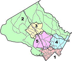
Current Montgomery County council districts.
In Prince George’s County, where there are no at-large members, planning policy divides the county into three tiers: the “developed tier,” mostly inside-the-Beltway areas originally formed around streetcar lines; the “developing tier,” the more recent car-dependent suburbs; and the “rural tier,” the mostly undeveloped areas.
Unfortunately, that county has been far less committed to maintaining their tiers and playing to the strengths of each. Inside the Beltway, where the county should focus a lot of its development in its underutilized Metro stations and commercial corridors, there has instead been little attention. The middle tier has expanded, with rural areas getting large car-dependent megadevelopments, housing subdivisions, and strip malls.
One of several reasons for this is because individual councilmembers tend to want development in their districts. A project brings opportunities for the member to shape development and push for benefits to residents or nonprofits in that district. Therefore, those representing rural districts or even fairly built-out suburban ones haven’t been content to simply let all the growth happen in the other, denser districts.
Yet that’s what should happen, and traditionally has in Montgomery. The most job and housing growth should happen in the core areas, the communities on Metro and/or inside the Beltway. Some growth will happen outside, and should be concentrated as much as possible in areas with decent transit access. And very little to none should occur in the Ag Reserve.
Under the current boundaries or the Spence map, almost all councilmembers would be participating in the county’s growth if it kept to this pattern. Under the Kahwaty one, the vast majority of the action would happen in districts 1 and 5, with only a small amount in 3 and 4.
Western Montgomery County Citizens Advisory Board President Jeff Hearle told the Examiner, “Bethesda and Silver Spring seem to me to be, from a development perspective, more aligned than Bethesda and Poolesville.” That’s actually a reason not to put them all in the same district. Every place facing similar changes need not, and in fact should not, be represented by one person.
Sometimes, drawing districts that span urban and exurban areas is a gerrymander aimed at diluting urban voting strength. For example, in Texas, the congressional district lines split Austin into many small pieces, each connected to a larger and more Republican area, with the intent of reducing the number of Democrats elected from that state.
But districts can be overconcentrated as well. Highway projects have a political leg up over transit projects, not because of the number of people they affect, but because all the affected people tend to reside in a smaller number of congressional districts. The benefits are tremendous for one member of Congress while nonexistent for another, instead of diffusely spread among several.
The current Montgomery County boundaries avoid many of these problems. A new map should maintain the overall layout and mix urban, rural, and suburban land types in as many districts as possible.