Map contest winners, part 5: Commuter rail and short turns
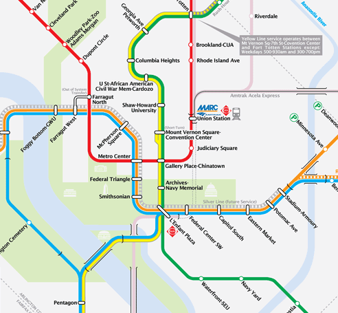
While the jurors in our map contest tended to lean toward maps with the familiarity of Wyman’s design, the voters in the peoples’ choice element sided with maps that took a fresh look at the system. The third place finisher in the people’s choice voting was Map B, by Andrew Duggan.
Andrew’s design uses thin lines, which he describes as “delicate”, in contrast to the “fat” lines of Wyman’s original design. Several maps took this approach, and it does seem to offer a cleaner, less cluttered design.
Another innovation of this map was showing the region’s commuter rail lines. The current map only shows commuter rail connections at intermodal stations. Map B took the approach of inserting the actual lines on the map. This map wasn’t the only one to show commuter rail lines, though only a few contestants chose to include those lines.
Map B had one attribute in common with the third place finisher in the jury contest: showing short-turn points using a “spur” at the terminal. This feature calls attention to places like Silver Spring, where half of all Red Line trains terminate.
Overall, the map offers a clear design, though it does include one major flaw that needs to be addressed. Perhaps illustrating the difficulty in describing Metro’s soon-to-start Franconia-Greenbelt service, the author of this map seems to have misunderstood the mechanics of the shift. He shows the Blue Line reroute as a service that runs from Franconia to Largo by way of the Yellow Line bridge, rejoining the Blue Line on the lower level of L’Enfant Plaza.
In reality, when this new service starts next year, trains on the Blue Line reroute will not rejoin the current Blue Line at L’Enfant Plaza, but will continue northward along the Yellow/Green Line to Greenbelt.
In spite of that error, the map represents a great attempt at a redesign. And it proved popular with voters, receiving 118 first-place votes.

