Not just downtown: DC needs more rapid transit between neighborhoods
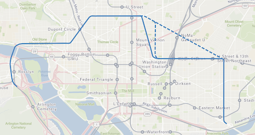
How the Blue Line could be realigned to foster inter-neighborhood mobility. Captured via Felt. Image by the author.
Regional transit aficionados know the Metrorail system was designed with an eye on commuting and regional trips. However, today’s transit needs are not confined to getting to and from office jobs downtown, and the importance of non-commuting trips is growing.
Off-peak and weekend ridership recovered faster post-pandemic compared to weekday commute trips, while local bus trips are growing as a share of total transit ridership. At the same time, the rise of teleworking, decentralized employment, and suburb-to-suburb commuting all reduce the need for transit infrastructure to focus so heavily on the downtown core.
If WMATA and regional leaders wish to grow transit ridership and shift trips from automobiles they will need to plan connections between mixed-use and high-activity neighborhoods, serving trips for recreation, daily needs, and commuting at all times of day and all days of the week. Within DC, these high-activity neighborhoods include Dupont Circle, the 14th Street Corridor, the Georgia Avenue Corridor, the H Street and Benning Road Corridor, and Historic Anacostia. These neighborhoods fall in an arc around the tourism and employment-focused downtown.
Population Density Map of Washington, DC in 2010 from DC Policy Center. Grey (0-1.5 people/acre), Purple (1.5-7.5 people/acre), Pink (7.5-15 people.acre), Orange (15-30 people/acre), Yellow (>30 people/acre). Image used with permission.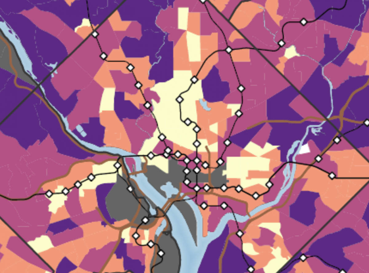
To meet demand for trips between these neighborhoods, the region sorely needs better orbital transit within the District, following the arc of these densely populated areas. In Maryland, the long-awaited Purple Line will laudably meet demand for suburb-to-suburb commuting in Prince George’s and Montgomery counties, but currently planned transit capital projects do not address inner-orbital connections inside the District.
The state of inner-orbital routes in the District
Few transit options currently attempt to make inner orbital connections within the District, and none does so successfully. The best is likely the 90/92 series of bus routes. The 90/92 buses provide a vital orbital connection and are consistently packed. These routes were identified by Dan Malouff in 2018 as “one of the city’s most important surface transit corridors.”
90/92 routes. Captured via Felt. 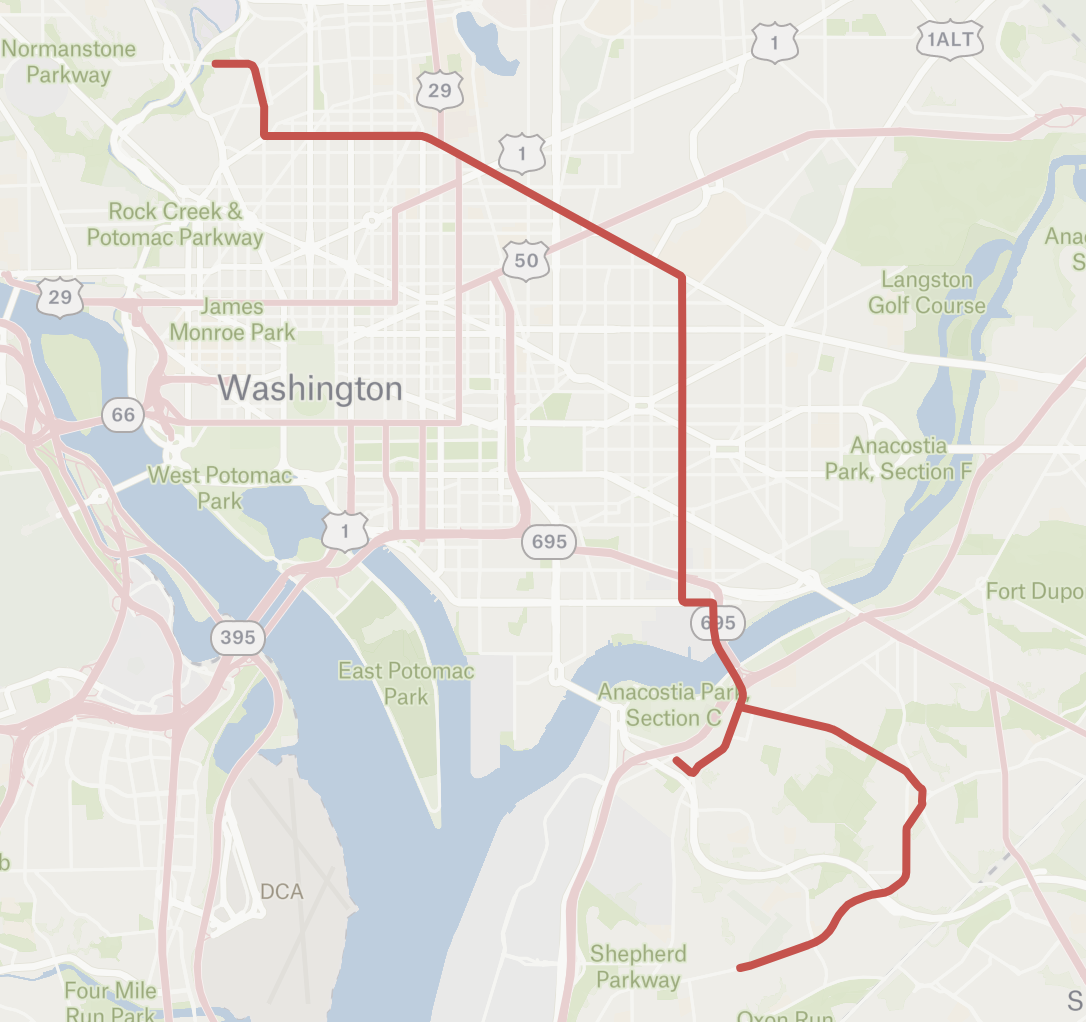
The 90/92 buses come frequently but the horrendous Dave Thomas Circle and congested Florida Avenue consistently cripple the services with delays and slow crawls. To go the 1.4 miles from NoMa to U Street takes 12 minutes on the 90/92 — a mere 7 miles per hour — according to Google Maps. Other orbital bus lines such as the 40 series have poor connections with Metrorail and other bus routes.
Current plans
Both WMATA and DDOT are currently planning major transit capital improvements. While their scope and ambitions differ greatly, neither agency’s plans will provide the inner-orbital transit connections DC needs.
WMATA’s only major capital project in the works is the Blue/Orange/Silver Capacity project and potential realignment. This planning focuses mostly on alleviating the crush loads and limited capacity through the Rosslyn tunnel, but it could also add several new stations.
This project gives the region its best opportunity to address orbital transit inefficiency within the District. Some of the proposals would provide access to high-activity areas currently not served by Metrorail, like the H Street Corridor and Ivy City. But none of the proposed alternatives provide substantially new transit connections between high-activity neighborhoods in the District. Each alternative serves the same M Street Corridor, which is near existing Orange/Blue/Silver Line stations and serves primarily office-dominated areas.
Core route of proposed Blue line realignments through downtown DC from Rosslyn to Union Station. Proposed silver line realignments follow a similar path. WMATA proposed routes found in Blue/Orange/Silver Capacity Reliability Study. Image Captured via Felt. Image by the author.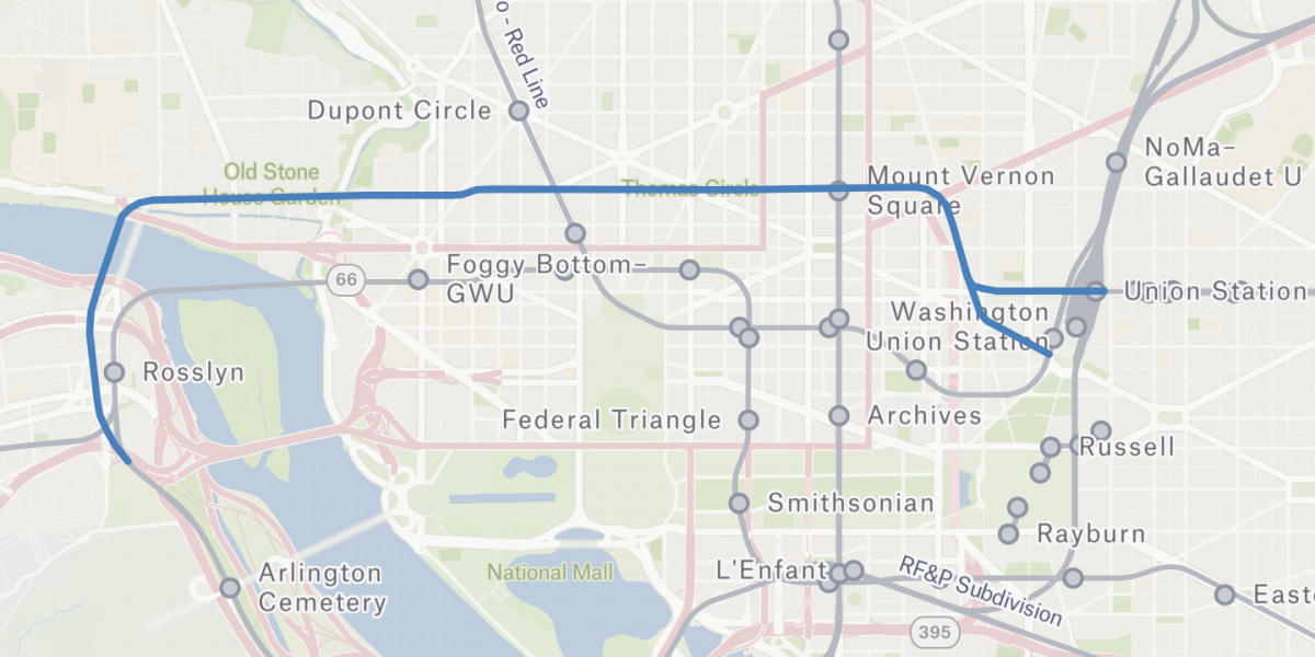
The proposed alignments within the District are oriented towards commuter capacity by mirroring pre-existing Metrorail corridors; no different than the function of the existing system.
DDOT takes a more intra-city approach to transit capital investment. The agency has completed or is planning multiple notable bus priority projects, many of which address inadequate neighborhood-to-neighborhood transit options. Notable improvement corridors are shown on the map below.
Corridors gathered from DDOT Bus Priority program. Captured via Felt. 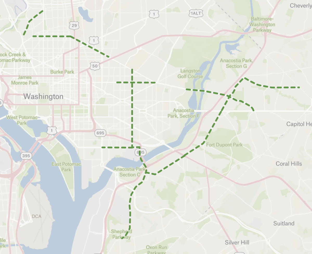
These projects represent significant improvements for riders, yet these upgrades aren’t a silver bullet. Buses will struggle to deliver the needed capacity, speed, and reliability to serve every type of trip.
WMATA is also currently in the process of redesigning and renaming its bus network. However, this has limited potential to substantially improve inner-orbital connections. Some of the proposed changes can improve riders’ orbital transit experience, for example increased frequencies on the B2 route, redesign of the 96 route to include H Street, and a new C57 route that directly connects the Benning Road and U Street Metro stations.
Potential solutions
WMATA and DDOT can prioritize inner-orbital connections by reinvigorating old plans and rethinking current ones. While I don’t advocate for any single project to serve these types of trips, I do think a range of aspirational transit plans can help convey the features, priorities, and intent that we hope to see in future transit expansions. As the region considers transit expansion, let’s advocate for planning that prioritizes neighborhood-to-neighborhood connections over periphery-to-downtown ones.
Better Blue Line Alignment
Among all the potential ways we should think about inner-orbital connections, the Blue/Orange/Silver capacity study has the most potential to be transformational. Establishing inner orbital routes should have been, and still could be, one of the goals included in the Blue/Orange/Silver capacity study. The map below shows potential Blue Line realignment options that meet that goal. A realignment prioritizing connections between District neighborhoods could partially replace current orbital bus routes like the 90/92 and 42/43 with grade-separated heavy rail.
How the Blue Line could be realigned to foster inter-neighborhood mobility. Captured via Felt (same as header image). Image by the author.
This and similar alignments would still provide relief to the Rosslyn tunnel while also delivering new direct rapid mass transit connections between densely populated neighborhoods.
The 99!
In 2018, Dan Malouff emphasized the importance of moving ahead with Metro’s proposed express bus route on the 90/92 corridor. This service, referred to as the 99, would likely add service and speed to a slow corridor with crowded buses. The 99 was studied in 2011 and was supposed to be paired with bus priority projects in 2014 but was never implemented. The 99 or a similar service was also not proposed in the WMATA bus redesign and only now is DDOT moving on a Florida Ave bus priority project — that’s a shame.
Map of earlier proposed 99 bus route. Image created by WMATA but archived on GGWash article. 
When combined with bus priority projects, express services can have an appreciable effect. Faster, more frequent bus service is a certain method to provide riders with better connections. Still, a bus will never be able to meet the needs of the crosstown Florida Avenue Corridor. Even with infrastructure improvements, the narrow right-of-way and traffic-clogged route will get in the way of making buses a true alternative to rapid mass transit.
DC Streetcar Improvements
Inner orbital options don’t need to necessarily follow an arc route. Well placed rapid mass transit connections from the core to peripheral neighborhoods can improve inner-orbital trips if they are frequent, travel faster than automobiles on average, and connect seamlessly to existing rapid mass transit. For example, the Green and Red Metro lines allow for transit riders to quickly travel between the U Street and Rhode Island Avenue Metro stations despite an indirect route.
The DC Streetcar could similarly serve inner-orbital trips, if it is upgraded and extended. To be effective, the streetcar needs dedicated lanes, priority at intersections, and extensions to connect seamlessly to the Gallery Place, Union Station, and Benning Road Metro stations.
However, the DC Streetcar has not been extended or improved since it was first built. DDOT plans to add dedicated bus/streetcar lanes to H street but proposed extensions have so far been rejected or postponed. We can have better inner-orbital transit if we build off DDOT’s H Street bus lanes and commit to extending the streetcar. Additional extensions to Georgetown and Coral Hills with planning akin to a light rail rather than a streetcar could make it an even better inner-orbital transit service.
Crosstown Rapid Mass Transit East of the Anacostia River
The Minnesota Avenue corridor in wards 7 and 8 spans one of the longest gaps between Metro stations within the District. The multiple bus priority projects along Minnesota Avenue should improve transit within this gap, but riders deserve better for such an expansive orbital route.
An abandoned railway corridor, the Shepherd Industrial Spur, already exists between these destinations, and could be turned into a transit corridor. In fact, this was the original route the Anacostia Streetcar line was supposed to take, before running into financial and legal roadblocks. Transit along the old unused freight tracks could connect the Green Line’s Anacostia station with the Minnesota Avenue station on Metro’s Orange Line.
In 2019, DDOT started a project to turn the Shepherd Industrial Spur into a multi-use trail. It’s a great idea, but a trail plus transit would be even more effective at delivering transportation options for residents in Northeast and Southeast.
Map of Shepherd Industrial Spur; captured via Felt. Image by the author.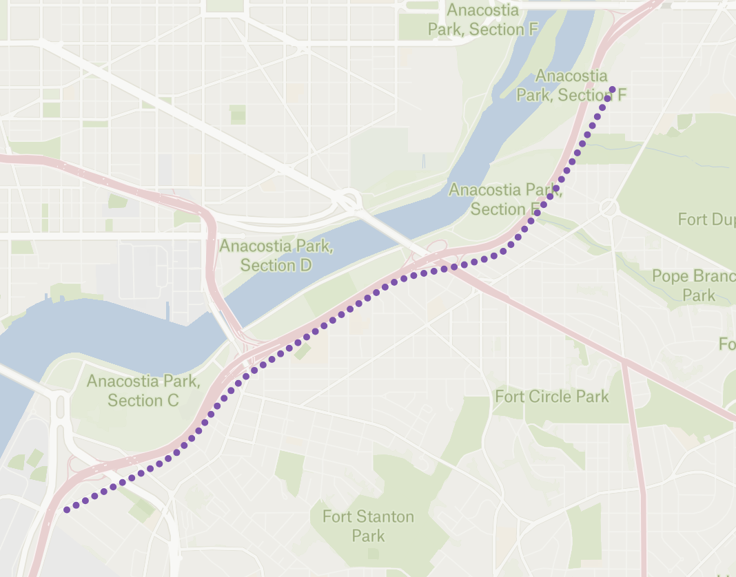
The combination of an abandoned right-of-way and an important inner orbital corridor is an unmatched opportunity to expand orbital mass transit. Promoting projects similar to the original Anacostia Streetcar line would exemplify how all types of trips deserve higher-order transit.
Connect the dots (please)
The downtown-focused and commuter-oriented designs of transit within the DC region and District meet only a subset of residents’ current travel patterns. If the appeal of transit is to grow in the District, our planning and expansions will need to account for everyday trips. Inner-orbital transit lines are important in serving these trips and attracting and keeping riders.