Here are MDOT’S 7 possible alternatives for the North-South Transit Corridor in Baltimore

Map of all seven North-South Baltimore transit alternatives overlayed on each other by Maryland Transit Administration used with permission.
Baltimore region stakeholders and residents can now provide feedback on another set of transit plans aimed at increasing regional connectivity and improving the region’s economy.
In September of 2022, the Maryland Department of Transportation (MDOT) and Maryland Transit Administration (MTA) announced a set of North-South Baltimore City/County transit system alignments (known in the report as alternatives) for public comment and review as part of the rollout of its Central Maryland Regional Transportation plan.
The entire Central Maryland Regional Transit Plan launched in October of 2020 to explore new rapid transit options for two “Transit Corridors” in the Greater Baltimore area, determined to be the highest priority areas to improve transit over the next 25 years in Central Maryland. Public comment on the East-West Baltimore City/County options happened in the spring and summer of 2022.
The East-West transit routes bore a striking resemblance to the approved but later canceled route of the Baltimore Red Line, which continues to be a political lighting rod throughout the state. It’s also the only part of the 2002 Baltimore Regional Rail Plan that advanced to the stage where major planning and funding were allocated by state and federal agencies.
How Maryland chooses to move forward with this new plan amidst a gubernatorial transition and increasing competition for funding with other transit projects even at the state level will determine how much of a difference either of these transit alternatives can make in the transportation and the economic fortunes of its largest city.
Here are the seven North-South alternatives at a glance:
Alternative 1
Map of Alternative 1, light rail transit from Lutherville to University of Maryland Medical Center. 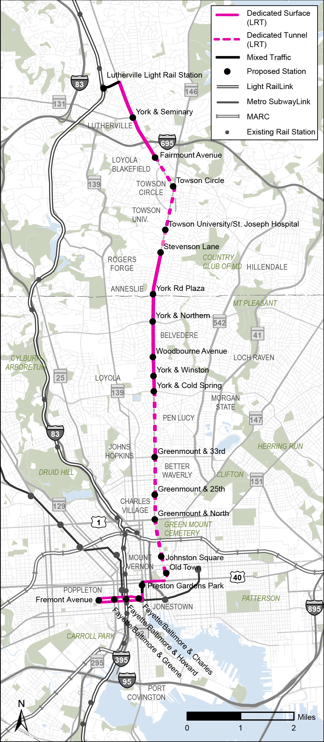
This is one of two alternatives that take the form of Light Rail and if it looks a little familiar, that might be because it largely parallels one of the MTA’s most popular existing bus routes, the CityLink Red. Alternative 1 begins at one of the stops for Baltimore’s existing light rail line, Lutherville, then travels south towards Baltimore City on one of the region’s busiest thoroughfares, York Road, on a mix of dedicated surface lanes and the first of two dedicated tunnels.
After four stops in Towson, Baltimore County’s seat and its largest community, the line crosses into Baltimore City, where it travels down the rest of York Rd. and most of its connecting street, Greenmount Avenue, again via a mix of dedicated surface lanes and tunnels, before using the Orleans St. Viaduct to connect to St. Paul St. and head slightly westwards to Downtown Baltimore, where it wraps up at the University of Maryland Medical Center (UMMC).
The 11.6-mile, 21-station line would include stops for Towson University, St. Joseph Medical Center, and a popular shopping center and food hall called Belvedere Square. This alternative is also notable as creating the most access to jobs for people living along this corridor.
Alternative 2
Map of Alternative 2, bus rapid transit from Lutherville to University of Maryland Medical Center. 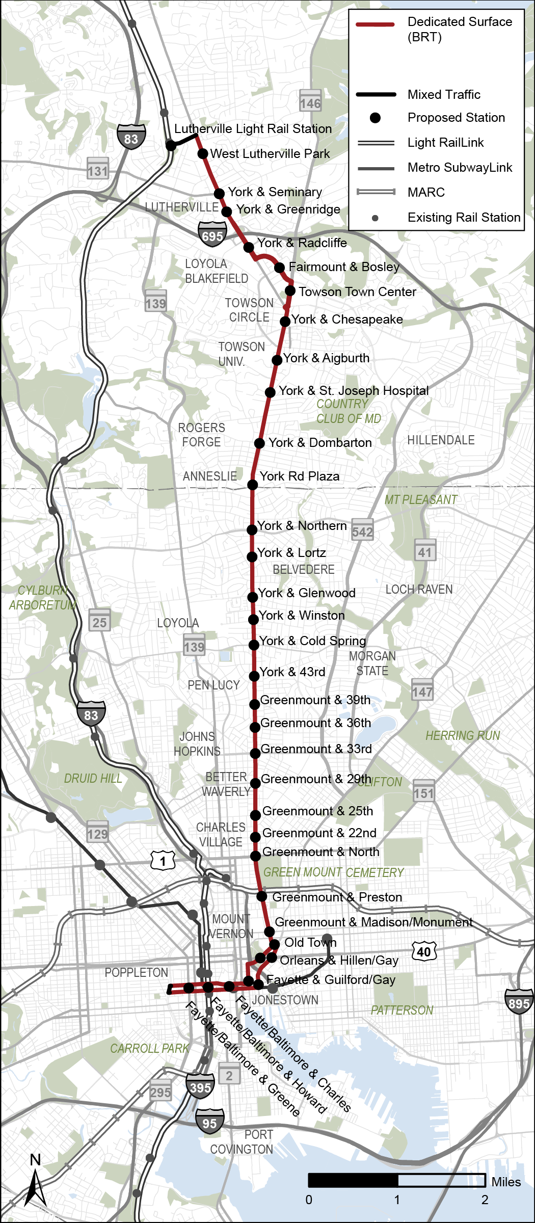
Alternative 2 would actually be fairly similar to Alternative 1, with a couple minor differences (it’s only 11.5 miles and has 33 stations) and some more substantial ones, namely that it would be a bus rapid transit (BRT) line traveling mostly but not entirely in dedicated lanes down York Rd. and Greenmount Ave., before turning left at Hillen and Gay streets in Downtown Baltimore and terminating at UMMC.
Alternative 3
Map of Alternative 3, bus rapid transit from Towson to Harbor East via York Road/Greenmount Avenue 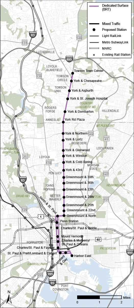
This is one of four BRT alternatives, though unlike Alternative 2, it would begin directly in Towson at one of Greater Baltimore’s main shopping malls, Towson Town Center. After that, the 9.2-mile, 28-station line would also head down York Rd. and Greenmount Ave. before turning west in Midtown Baltimore to merge with St. Paul St., then southeast at Pratt St. in Downtown Baltimore before terminating at Harbor East, an upscale waterfront shopping development adjacent to the Inner Harbor. The advantages of this line would include traveling exclusively in dedicated lanes and, unlike the first two options, stopping at Penn Station.
Alternative 4
Map of Alternative 4, heavy rail transit (subway) from Towson to Port Covington 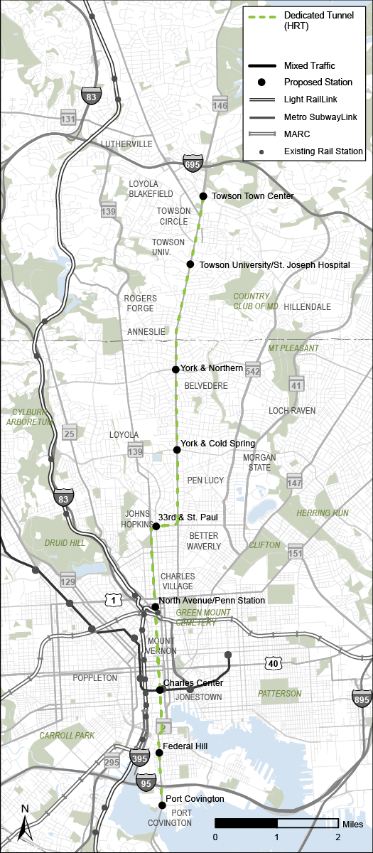
This 10.5-mile, nine-station line is the only one of the seven alternatives to take the form of heavy rail, traveling exclusively in dedicated tunnels for its entire length. Like Alternative 3, it would start at Towson Town Center and follow York Rd. south into the city before turning west, though in this case it would be to follow 33rd St. and St. Paul St. Instead of just stopping downtown like the first three alternatives though, Alternative 4 heads south past Federal Hill before wrapping up at Port Covington, the high-profile mixed-use redevelopment project associated with Under Armour mogul Kevin Plank. Unlike the first 3 alternatives, this line wouldn’t stop in Waverly, the neighborhood home to one of Baltimore’s most popular farmer’s markets, but would stop at Johns Hopkins University.
Alternative 5
Map of Alternative 5, Bus Rapid Transit from Towson to Port Covington 
Like Alternative 4, this 10.4-mile, 30-station route would travel from Towson Town Center to Port Covington but via BRT instead of heavy rail. Once again, the line would run down York Rd. and Greenmount Ave., then west on 33rd St. After that, it would join a one-way pair of St. Paul and Charles streets, before terminating at Port Covington. On the plus side, Alternative 5 would serve both Waverly and JHU and mostly use dedicated lanes. On the down side, the two areas where it would run in mixed traffic would add to existing congestion downtown near the Inner Harbor and under the I-95 viaduct near Hanover St.
Alternative 6
Map of Alternative 6, Light Rail transit from Lutherville to Otterbein 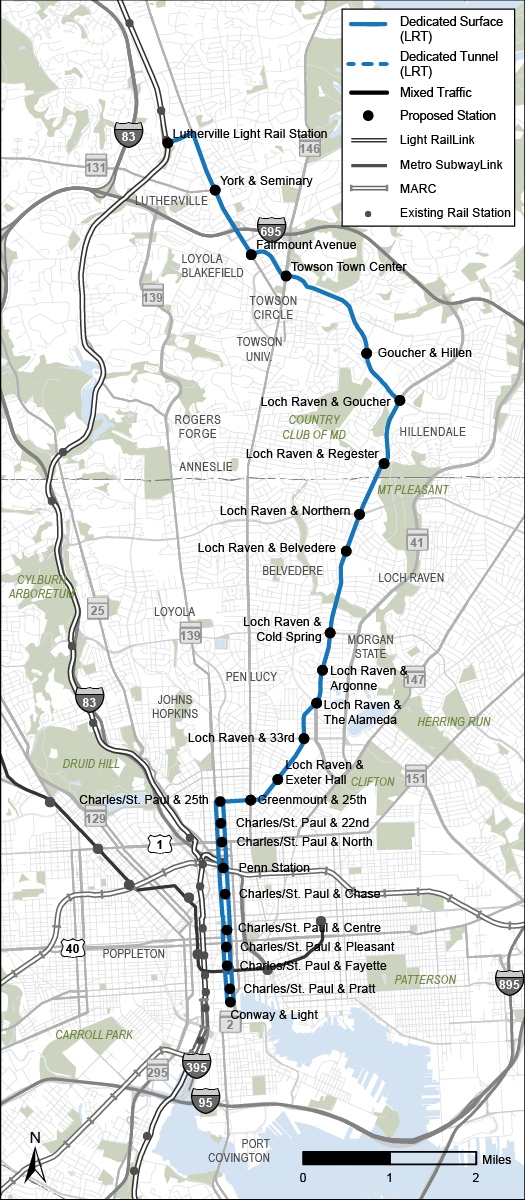
This 12.5-mile, 25-station light rail route would opt for a slightly more easterly route than most of its counterparts. Like Alternative 1, it would start at the Lutherville Light Rail station but instead of heading directly south on York Rd., it would quickly turn southeast on Goucher Boulevard to Loch Raven Boulevard, then continue south on that road past the City line until 25th Street, then connect to the one-way pair of Charles & St. Paul and wrap up in the Downtown-adjacent neighborhood of Otterbein. Unlike most of the other alternatives, it wouldn’t stop near Towson University, Belvedere Square, Waverly, JHU, or Port Covington. It would, however, provide access to Good Samaritan Hospital, Morgan State University, and Penn Station and it would travel entirely on surface streets in dedicated lanes.
Alternative 7
Map of Alternative 7,Bus Rapid Transit from Towson to Harbor East via Joppa Road 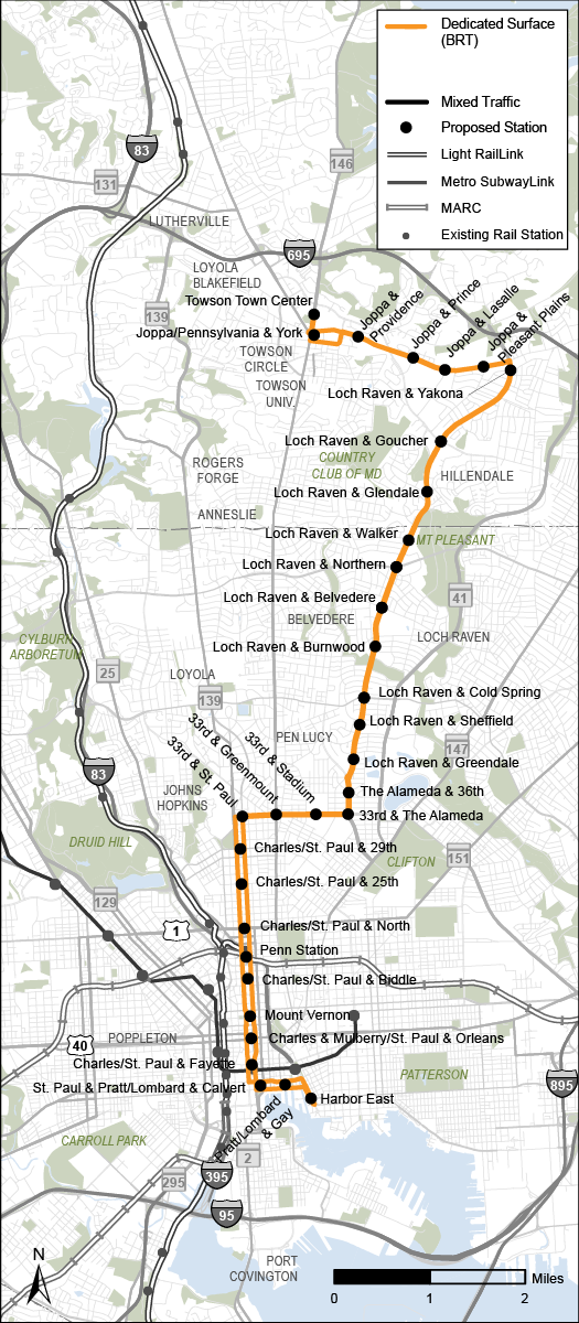
Alternative 7 isn’t the only option which would run from Towson to the Inner Harbor but at 12.6 miles and 32 stations, it would definitely be the longest route and the one with the most stops. From Towson Town Center, the line travels down Joppa Road, then onto Loch Raven Blvd. into the city, then onto 33rd St. and finally onto Charles & St. Paul before finishing at Harbor East.
So what comes next?
The immediate short-term steps for the North-South Corridor planning process are pretty straightforward. MDOT is currently circulating an online survey inviting the public to weigh in on their preferred options with a deadline of Nov. 7 and has scheduled two virtual meetings for public feedback, the first of which was held on Sept. 22 and the second of which is scheduled for today (Oct. 3) from 6:00 to 7:00 p.m.
Beyond that, the schedule for turning these alternatives into something more concrete in terms of funding and further planning is a little more uncertain. As with the East-West Corridor, MDOT and MTA will take the public feedback they’ve collected and use it to perform more engineering and environmental analysis and narrow the alternatives down to a single option.
But from there, it’s up to the next Governor and General Assembly to work with MDOT and local stakeholders to shape a clearer timeline. And as the MTA explained in a statement, there’s fairly clear incentive for the region to do that: “The Towson to downtown Baltimore corridor is currently served by three of the most utilized routes in the MDOT MTA local bus network - the CityLink Red, Green, and Silver in addition to the LocalLink 52. The CityLink Red is one of the highest ridership routes in the Baltimore service area. The robust existing ridership on these routes is one of many indicators that this is a corridor that would benefit from additional transit investment.”