Two plans devise opposite approaches for Rockville Pike
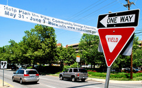
Photo by M.V. Jantzen on Flickr.
Two separate plans in Montgomery County hope to transform parts of Rockville Pike from disjointed chains of strip malls into walkable districts. Each would reconfigure the road to more urban boulevard layouts, but each does so differently, carrying some leading to a danger of creating two, slightly incompatible configurations adjacent to one another.
At White Flint, in unincorporated Montgomery County, a multi-year planning process led to development plans and zoning that encourage converting the many large commercial properties into a mixed-use neighborhood that contains parks, day care centers, affordable housing, retail and much more.
One centerpiece of this plan is a configuration for Rockville Pike which places a transitway down the center while maintaining the current number of travel lanes. Buses, and possibly one day light rail, can more efficiently travel up and down the Pike, allowing more people to live in the area without increasing traffic.
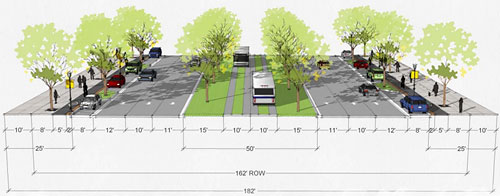
White Flint roadway design.
To the north, the city limits of Rockville begin just south of Rollins Avenue and encompass the portion of the Pike around the Twinbrook station. There, the city has conducted another multi-year planning process, also aiming to create a walkable district with street-facing buildings, a more complete street grid, parks and more. In fact, I attended a meeting for this plan over three years ago for one of the earliest articles on Greater Greater Washington.
Rockville came to a different conclusion for the Pike. They want to build a “multi-way boulevard” with through lanes in the center and side roads designed for turning traffic, parking, buses, and bicycles.
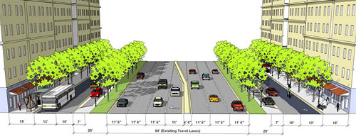
Rockville “multi-way boulevard.”
Both designs constitute an improvement over the current Rockville Pike, but they solve the problems in different ways. Each has advantages, disadvantages, and simple differences.
Width. The Rockville plan would widen the overall roadway, placing some of the outer lanes on land currently occupied by parking lots. This means that it can’t be constructed all at once, but would happen piecemeal as properties redevelop. The White Flint model fits within the existing roadway.
Pedestrians. The White Flint option provides a median so pedestrians, especially ones who move slowly, don’t have to cross any large sections at once. On the other hand, the Rockville option keeps the fast-moving through traffic farther from the sidewalks, potentially creating less of a feeling of walking right on a highway.
Bicycles. The Rockville design plans for bicycles to use the curbside lane, which separates them from the main traffic. However, they would still have to mix with turning vehicles, buses, and delivery vans. The White Flint plan, on the other hand, includes a bike lane at sidewalk level between the pedestrian part of the sidewalk and the road.
Transit. Buses will be able to move faster under White Flint’s arrangement, and it would be easy to create light rail in the future. The center transitway can also use grass for most of the roadbed except for narrow strips for the buses’ wheels, providing opportunities for stormwater retention. On the other hand, Rockville’s arrangement puts bus stops closer to the stores that will open onto the street.
Drivers. Drivers might find moving in and out of service lanes confusing or frustrating, as they do on K Street. However, the Rockville plan provides more overall through lanes.
Ironically, DC currently hopes to transform K Street from a model that looks like the Rockville design, though a little narrower (one through lane on each side road plus one parking lane instead of two through lanes, and without a turn lane in the center), into one very much like the White Flint design, though one lane narrower on each side.
Is it necessary to harmonize the two? They could operate next to one another, though there would be some conflict. Buses would have to switch between center lanes and outer lanes. It could be confusing for drivers. And it doesn’t lay the groundwork for a rail line along the entire stretch, as ACT has proposed.
Rockville and Montgomery County need to determine whether it’s better to let each district go its own way, making their own choices, or whether it’s more important to have one, unified street design for the entire corridor, even if that means some areas or some leaders don’t get their top choice.
The Rockville Planning Commission is discussing the plan at a meeting tonight, 7 pm at Rockville City Hall.