Central Virginia is planning a 41-mile trail from Ashland to Petersburg

A person biking on the Virginia Capital Trail by VDOT.
This article was first published on October 1, 2019. As plans for the trail move forward, and with a growing need for more recreational space, especially during the pandemic, we thought we would share this piece with you again.
When the Virginia Capital Trail was first proposed back in 1999, critics derided the idea of the 51.7-mile multi-use path as overly-ambitious and too expensive. Today, the east-west trail connecting Virginia’s first capital of Jamestown with the modern seat of government, Richmond, faces concerns about overcrowding, and there’s now a sister trail in the pipeline.
Far from being a waste of taxpayer dollars, the Capital Trail has become one of the state’s highest visited amenities. The only other multimodal path to receive more visitors on an annual basis is Virginia Beach’s oceanfront boardwalk. The Virginia Department of Transportation (VDOT) is leading an effort to replicate the Capital Trail’s success with a north-south alignment, tentatively called the Ashland to Petersburg (ATP) Trail.
When the trails aligned
An entire economy has sprung up around the Capital Trail, including restaurants and wineries situated along it to lure cyclists, joggers, and walkers. The City of Richmond leverages the path’s western terminus to drive foot traffic to its downtown Shockoe Bottom neighborhood. Amtrak even offers deals on one-way trips (including a bike) between Jamestown and Richmond for those who find a 103.4-mile round trip intimidating.
The success of the VCT inspired VDOT staffers and local officials across the region to explore a trail that could become the multimodal backbone of Central Virginia. The proposed ATP Trail would extend roughly 41 miles and pass through seven of Central Virginia’s localities: the City of Ashland in the north, Hanover County, Henrico County, the City of Richmond, Chesterfield County, and the Cities of Colonial Heights and Petersburg in the south.
The preferred alignment for the ATP trail. Image by VDOT.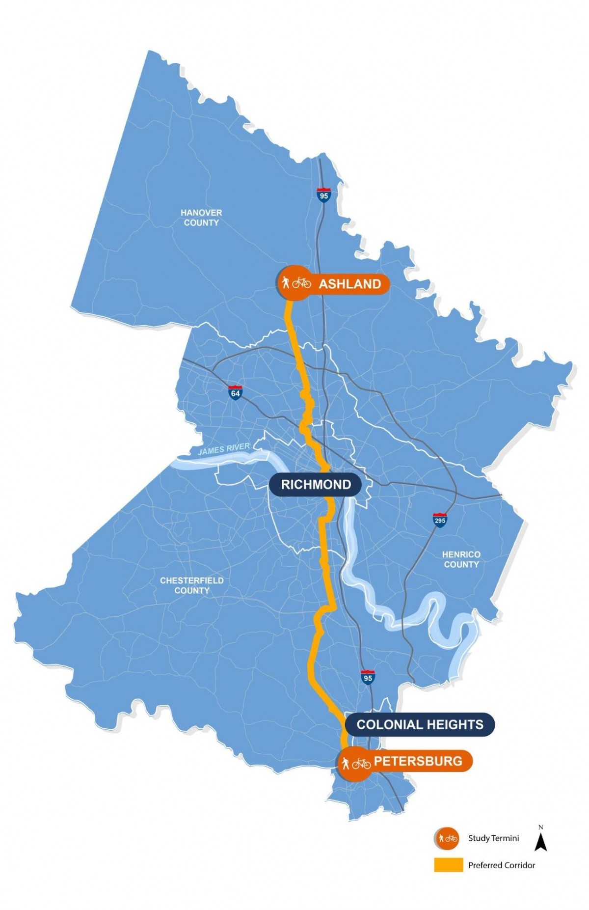
Palmer Stearns of the VDOT Richmond District Office explained, “This is a collaborative planning effort with the seven localities, the Crater Planning District Commission, and PlanRVA to explore a preferred corridor for a regional trail and put together a pool of information that can be used for funding opportunities going forward.”
Planners and municipal officials weighed six different possible alignments in an attempt to ensure the ATP Trail passes within a half mile of most regional amenities, then narrowed the options to two finalists. Of the top two choices, the orange route was selected for public review as the preferred alignment.
“The orange corridor best met the needs and preferences of the study without any major environmental impacts to wetlands and other sensitive ecosystems while staying at a cost that is practical,” Stearns said.
How to cross the James River?
The trickiest section of the proposed alignment will be the use of the T. Tyler Potterfield Memorial Bridge to cross the James River. Since its completion in 2016, this predominantly pedestrian bridge has become a major waterfront attraction in Richmond and faces its own issues of heavy traffic and overcrowding.
“Right from the beginning of the study we knew the crossing at the James would be a big constraint,” Stearns said.
The addition of hundreds more daily users, mostly on bike, may not be feasible or safe. Current rules don’t dictate that cyclists must dismount to cross the T. Pott Bridge, but that practice is standard for similarly narrow pedestrian bridges. If ridership numbers for the ATP Trail match those of the VCT, then what can be an already tricky crossing of the James may get tougher with an additional 300 cyclist crossings per day.
In light of these concerns, some Richmond residents have already begun to propose alternative alignments over the James. While VDOT’s planners only explored existing surface bridges, one idea from the public envisions a suspension bridge under I-95 similar to the pedestrian bridge to Belle Isle that hangs below Route 1.
Other locals view the situation as a “once in a lifetime chance to take back some lanes on the Manchester Bridge.” The six-lane bridge was originally built to accommodate I-95, but today sees little traffic. Such an alignment would dovetail nicely with the proposed Bridge Park RVA, a community-driven project to repurpose several of the Manchester Bridge’s lanes for foot and bike traffic only.
Mockup of Bridge Park. Image by Bridge Park RVA.
Weigh in on the Virginia Capital’s new trail
Some portions of the ATP Trail’s proposed alignment already exist, such as Chester Linear Park and the Ashland Trolley Line. Others are already in the planning phase, like the Lakeside Community Trail in Henrico County. The vast majority, however, will take years to build, including segments that cut through Richmond’s dense urban street grid and run along Colonial Heights’ abandoned railroad.
Stearns believes the project offers a slew of ways to improve safety and mobility for people in Central Virginia: “Along the entire corridor there are a lot of opportunities to fix some gaps in the infrastructure and make some new connections to existing amenities and destinations. From a regional perspective we’re really proud of the whole alignment. We weren’t looking at one locality more than any of the others. This trail is going to be a huge benefit to all seven.”
People biking on the Virginia Capital Trail by VDOT.
“Community feedback is a huge part of how we move forward on and mold these studies,” said Bethanie Glover, a Communications Manager at VDOT. Now that VDOT has officially proposed an alignment for the ATP Trail, the agencies and localities involved want to hear from the public. Even the name of the trail itself is still open to debate.
The public meeting for the trail’s southern half was held September 30 in Colonial Heights. On Tuesday, October 1 officials will hold an informational meeting for the public at Lewis Ginter Botanical Garden in Henrico.
Those who missed or cannot attend either meeting are invited to view the proposed alignment and provide their feedback through an interactive map of the trail online. The comment period is open through October 11 in order to give planners time to read and incorporate the public’s feedback into their completed study expected by March 2020.
Correction: A previous version of this article stated that current rules dictate that cyclists must dismount to cross the T. Pott Bridge. This is not the case.