Choose bike boulevards over bike lanes around H Street, NE
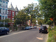
Photo by Full-Time Lover on Flickr.
The 2005 Bicycle Master Plan includes bike lanes on streets parallel to H Street NE, but bike lanes aren’t always the best approach. In this neighborhood, bike boulevards would help bicyclists while creating more obvious benefits for all neighborhood residents as well.
A “bike boulevard” prioritizes cyclists and pedestrians. And it provides motorists slower, more consistent speeds instead of the all-too-familiar race between stop signs and speed humps.
A combination of bike boulevard tools can make our streets safer and quieter. Some of these are familiar to the District, others are new. These strategies include sharrows, bulb-outs, modified speed humps and reorientation of stop signs.
As currently proposed, bike lanes on G and I Streets, NE between 2nd and 13th would be just fine. But DDOT could do even better by creating a neighborhood street that provides traffic calming for residents and road users while also giving a better facility to bicyclists by implementing some of the following treatments.

Sharrows on 12th Street NE. Photo by the author.
Sharrows, or shared-lane markings, are currently used on 12th Street NE and New Hampshire Avenue near U Street NW. Sharrows indicate priority and proper placement of cyclists, keeping them out of the door zone and letting drivers know the important role cyclists play on this particular street.
As bicycle planner Mia Birk notes, sharrows are often most appropriate when “the speed differential between cyclists and motorists is either low or zero.” Residential streets like G and I fit this situation perfectly.
The primary method of controlling speed on many residential streets has been the stop sign, with four-way stops at nearly every block. In theory, this keeps speeds low, but many drivers will speed between intersections, while both motorists and cyclists will slowly roll through stop signs. This makes the street experience frustrating, and sometimes dangerous.
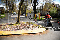
Photo by BikePortland.org on Flickr.
Bike boulevards on G and I would keep road users at a slow but steady pace by removing stop signs for east-west traffic and instead inserting mini-roundabouts at some intersections, so all road users must slowly negotiate the space together.
At intersections without mini-roundabouts, slow-moving east-west traffic would not stop, while north-south traffic would have stop signs. These “partial-stop” intersections, as seen at 5th and R NW, are not uncommon in DC.
There are more treatments that can be used to keep traffic traveling at a slow pace. Speed humps are a common sight throughout DC, but over-reliance has led to noisy and dangerous short-distance speeding by some motorists not unlike the speeding often seen between stop signs.
For a better example, we only have to look to Arlington, where some speed humps include groooves for motor vehicles. Motorists must slow to align their vehicles’ wheels with the grooves, but do not experience the cringe-inducing bounce that can sometimes scrape the undercarraige. By riding in the grooves, cyclists can reduce wear and tear on their bikes, as well.
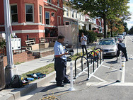
Photo by Washington Area Bicyclist Association on Flickr.
In addition to reducing crossing distance for pedestrians, bulb-outs are another feature commonly used to slow vehicle speeds by narrowing the roadway. While complete curb extensions may be too expensive to be implemented quickly on G and I, DDOT can create bulb-outs with bollards.
Areas near intersections where parking is currently prohibited for visibility reasons can also be converted into bike corrals, which provide bike parking and some protection for pedestrians without reducing visibility for motorists.
DC’s first bike corrals were recently installed in Georgetown and Columbia Heights. By serving the traffic calming needs of pedestrians, the parking needs of cyclists and the visibility needs of motorists without removing on-street parking, bike corrals can be a great addition to some neighborhood streets.
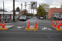
Photo by BikePortland.org on Flickr.
An important component of a bike boulevard is deterring through motor vehicle traffic. This has been accomplished in other cities by creating refuges in the middle of a cross-street that allow cyclists and pedestrians to cross while prohibiting motor vehicle turns and through movement.
It may be desirable to prevent motorists on G and I from continuing across 8th Street, or to prevent drivers on 8th Street from turning left onto G or I. The effectiveness of this type of prohibition at 8th Street — and whether the sacrifices made by drivers would be worth the reduction in through traffic — can only be determined by study from DDOT in consultation with the neighborhood.
H Street vs. U Street
The current plan for bike lanes along the H Street corridor is similar to how DDOT has managed bike facilities along the U Street NW corridor. Bike lanes are provided not on the major thoroughfare itself but are instead striped on parallel residential streets. Near U Street, T and V streets have bike lanes. In Northeast, lanes are planned not for H Street but on G and I.
The addition of streetcar tracks to H Street makes DDOT’s decision to provide altnerate routes for cyclists even more appropriate. While streetcar service will be a major mobility improvement, the introduction of streetcar tracks to H Street poses challenges for cyclists navigating the area. While there are ways to reduce the danger to cyclists, one of the best practices of bike/streetcar planning is the provision of parallel alternate routes for cyclists. G and I streets are an ideal alternative to H Street for bicycle traffic.
So why would a bike boulevard be better for G and I streets NE, while bike lanes are best for T and V streets NW? Although these corridors have some similarities, there are important differences. T Street, especially, functions as a secondary through route from Dupont Circle and Adams Morgan to Bloomingdale and Shaw. As a result, it carries significantly more motor vehicle traffic than G and I, which are cut off by Union Station at 2nd Street NE.
The difference is evident when you think about restricting through and left-turning traffic at major cross streets. Restricting through traffic along T Street at 14th Street, for example, would have a much bigger negative impact than doing so on G or I at 8th Street. Finally, for busier roads like T Street, bike lanes are a better choice because they carve out a space in the road for cyclists that would otherwise be taken by motor vehicles. This isn’t the case on quieter, more residential streets.
Bike boulevards were first implemented in American cities such as Berkeley and Portland and have become popular additions to their neighborhoods. When surveyed, the majority of residents on a bicycle boulevard in Portland “generally agree…that these low-traffic bikeways have a positive impact on quality of life, home values, sense of community, noise [and] air quality.”
Because cyclists are not the only beneficiaries of these traffic-calming interventions, Portland’s Bureau of Transportaton broadened the scope of its bike boulevards and rechristened them as Neighborhood Greenways. PBOT has also begun partnering with other city agencies to include features like vegetated stormwater capture areas that double as traffic-calming curb extensions. We’ve seen some similar work in our area, most recently on the sidewalk in front of the new Casey Trees headquarters in Brookland and by Constitution Square on 1st Street NE. The region’s most holistic “green street” is found in Edmonston, Maryland.
Looking ahead
DDOT is interested in implementing this type of facility; the agency is already looking at bicycle boulevards as part of the Rock Creek West II Livability Study.
It’s important to remember that not every bike boulevard must include the full complement of treatments. For example, it’s not always appropriate to restrict turns and through traffic, and curb extensions or stormwater capture areas could be cost-prohibitive for some projects. But as DDOT’s protected bike lane projects have shown, the agency is able to implement cost-effective facilities that have been done at greater cost elsewhere.
The District needs to expand its repertoire of bike facilities to include more than just bike lanes. With the addition of 15th Street’s protected bike lane and the Metropolitan Branch Trail, DDOT has strengthened the types and number of facilities that separate cyclists from other road users.
And while not every street should have a bike lane, every street should be a complete street. For quieter residential areas, bike boulevard treatments can be important tools as DC expands its bike network beyond the city’s core.