DC’s Comp Plan comes down to a lot of maps. Here’s why this one matters.
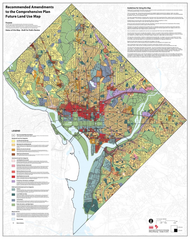
The entire Future Land Use Map from DC's Office of Planning of the FLUM Image by DC’s Office of Planning.
When DC Mayor Muriel Bowser and Office of Planning (OP) Director Andrew Trueblood released citywide targets for affordable housing production by neighborhood planning area, they also made public amendments to the rest of the Comprehensive Plan—all 24 chapters of it. The Comp Plan is important because it guides how the city will grow in the years to come.
On October 8, the council passed the Framework element, the intro which charts the direction for the plan. This is our first look at OP’s proposed updates to the rest of the document. GGWash will be paying particular attention to the land use, housing, and historic preservation sections, as well as the area elements of the Comp Plan as it’s revised.
Throughout October and November of last year, we posted our takes on the land use, housing, and historic preservation elements. GGWash also submitted review comments to the Office of Planning, which you can read in full here, and signed onto review comments submitted by the Housing Priorities Coalition, which you can read here. OP has extended the timeline for public review and ANC resolutions on the Comp Plan to Jan. 10 and Feb. 14, respectively; you can read more about how to be involved with that here.
Our comments to OP were largely focused on the intent, purpose, and format of the Future Land Use Map. We’ll get to what we said about the FLUM in a minute, but first, a refresher.
Lanier Heights' FLUM designation Image by DC Office of Planning.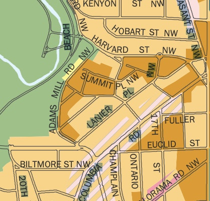
What’s the Future Land Use Map?
The Future Land Use Map—as stated on the map itself—is defined as “part of the Comprehensive Plan of the District of Columbia. Its color-coded categories express public policy on future land uses across the city. Preparation of this map is required by DC Law to ‘represent the land use policies set forth in the proposed Land Use Element,’ using ‘standardized colors for planning review.’”
David Whitehead, our former housing program organizer, wrote a great primer about the FLUM, and the Generalized Policy Map (GMP), back in 2016, when the process of amending the Comp Plan was just getting started:
“It colors blocks or parts of blocks with various broad land use categories, like “moderate density residential,” “high density commercial,” “federal government,” etc. Each of those categories are given specific descriptions in the legend, even as specific as including numbers of stories.
The colors represent a combination of what land use currently exists on the ground, and what planners predict for the future. In the end, when a governing body in DC is asked to interpret policies embedded in the various chapters of the Comp Plan, that body is supposed to refer back to the FLUM to clarify and guide their interpretation.”
The FLUM shows how dense parts of the city can be at maximum in the future, using those categories (“moderate density residential,” “high density commercial”). The FLUM is not a zoning map, and zoning can further restrict density below what the FLUM allows—because the FLUM is supposed to represent the future, not the present.
That space between what’s permitted by zoning and what’s allowed by the FLUM is where, and how, Planned Unit Developments (PUDs) happen. In exchange for public benefits, PUDs allow projects that are more dense than what’s legal under existing zoning to go forward, up to the density allowed by the FLUM. This is a common practice of discretionary development that happens in many municipalities; this sort of interplay between zoning codes and comp plans in the United States is a legacy left by 1920s-era progressive reformers via the Standard State Zoning Enabling Act. You can read more about PUDs here, and here.
"Upflumming" designations for 17th and U streets and 14th and U streets Image by DC Office of Planning.
Just let the FLUM live
It’s important that the FLUM be a FLUM, and the zoning code be a zoning code. They’re not the same document, and they aren’t updated at the same time (frankly, we didn’t spend the full decade between 2006 and 2016 updating D.C.’s zoning code to act as if it’s the same as the FLUM). They have fully different purposes: The zoning map shows what’s legally allowed at present, and the FLUM says how far—or, really how dense—you can go in the future. But, in our opinion, D.C.’s FLUM looks a bit more like a zoning map than it should.
In David’s 2016 post, he wrote:
“Does this sound like a zoning map? I can see why you’d think so, but in fact the language in the Comp Plan clearly states that this is NOT a zoning map. Instead, it is supposed to translate the land use policies in the Comp Plan text to a map, and act as a guiding document for the zoning commission when zoning changes are proposed.”
We wrote something virtually identical in our comments to OP on its most recent amendments Comp Plan, which include amendments to the FLUM:
“We are thrilled to see OP’s amendments to the FLUM change some areas, like Connecticut and Wisconsin avenues, from a lower-density to a higher-density category—they have, if you will, been “upflummed.” Any revision to the FLUM is more than we expected at the beginning of the Comp Plan amendment process, in 2017. Barring any amendments to the 2006 FLUM, the FLUM wouldn’t be a Future Land Use Map but, rather, simply, a map reflecting the current state of things, which would be contrary to its purpose.
That said, while OP’s proposed amendments create a more forward-looking FLUM than the 2006 version, we feel that it is still functionally closer to a zoning map than a planning map. We also feel that OP’s amendments are more fine-grained than is appropriate, or necessary, for something that ostensibly exists to address “public policy on future land uses across the city.””
Amendments to some areas carry out the above practice to such an extent that their representation on the FLUM looks more like a checkerboard of competing priorities than a unified neighborhood—for example, Southwest, along Wisconsin Avenue, Mount Vernon into Shaw, and Lanier Heights.
Some examples of where OP’s amendments are more zoning-like than FLUM-like are on single parcels or otherwise very small areas, like 17th and Park Road (which has been changed from medium-density residential to medium-density mixed use, presumably to bring the parcel into compliance with the actual current use, which is mixed-use, not solely residential).
The Reeves Center at 14th and U streets NW is “upflummed” from medium-density mixed use to high-density mixed use, including public facilities, and the Metropolitan Police Department station at 17th and U streets NW is changed from public-facilities to medium-density mixed-use. These are separate blocks but are literally three blocks from each other. They’re close enough that it doesn’t make sense to have varying FLUM designations for the blocks in between. If medium-density mixed-use at minimum is good enough for 14th and U and 17th and U, it’s probably good enough for 15th and 16th streets, too.
Overall, OP’s amendments areas carry out the above practice to such an extent that many neighborhoods’ representations on the FLUM looks more like a checkerboard of competing priorities than a unified neighborhood—for example, Southwest, along Wisconsin Avenue, Mount Vernon into Shaw, and Lanier Heights, within which FLUM designations vary wildly.
Certain parts of the city that have historically used legal mechanisms to resist development, like definitions from the FLUM, are still too-low density in their classifications to meaningfully allow for more housing, or more affordable housing. Lanier Heights, for example, alternates between moderate- and medium-density residential, in the checkerboarding fashion described above. Though Lanier Heights residents won an exceptional downzoning of their neighborhood in 2017, the FLUM—because it’s not a zoning map—should account for potential future land use; regardless of Lanier Heights’ zoning designation, its potential future density should be the same, and similarly higher, across the board.
When FLUM designations more strongly resemble zoning categories, the map looks like a checkerboard. Image by DC Office of Planning.
Why upflumming matters
We’re pleased to see OP revising the FLUM, and are particularly fond of OP’s proposal to increase the potential future density of upper Wisconsin Avenue and Connecticut Avenue.
Mayor Muriel Bowser wants to add 36,000 units of new housing by 2025, wants 12,000 of them to be affordable, and wants them to mostly go in planning areas like Rock Creek West, Near Northwest, and Capitol Hill, which have seen the least amount of affordable housing built. This cannot happen without increasing the potential future density of these neighborhoods. If they remain untouched, our development patterns will continue as they have: More vulnerable places will see more new stuff, and affluent neighborhoods will be off-limits. This isn’t fair, and we know it: It exacerbates segregation and inequality on a spatial scale. We’re already there.
The remedy to this is to much more broadly and uniformly upflum the whole city. Ideally, the lowest baseline—or, the minimum density and use allowed—in any given place in the city (outside of parks, recreation, and open space) would be moderate-density mixed-use. This eliminates the incentive to speculate on land’s future value by bumping everyone up to a uniform, higher standard, so that there isn’t such great variation across the board. Alternately—and, for what it’s worth, I, personally, prefer this approach—the density of each planning area could be progressively bumped up to this baseline, such that affluent, amenity-rich planning areas are upflummed first.
Fundamentally, no neighborhoods should be allowed to opt out, especially because, outside of its parcel-specific amendments to the FLUM, OP appears to be making an otherwise good-faith effort to plan at the scale of planning areas, of which there are 10 in the city, rather than individual neighborhoods. McLean Gardens was initially slated for an upflumming; that’s off the table now. That’s a poor precedent.
Why aren’t you talking about project-specific FLUM changes?
Bisnow covered how the FLUM changes could benefit certain developments when OP’s amendments were released in October.
We, of course, think it’s great that, for example, the part of the city that includes the McMillan sand filtration site is getting upflummed. But we are more interested in a FLUM that reflects how the city should work in the future—which is why this post is about how we should progressively arrive at a FLUM that is much more uniformly dense across the board.
Parcel-specific upflummings look more like parcel-specific zoning changes rather than broad-based reforms that can smooth out some of the uneven, and unfair, development that the city has seen.
How do I look at all of this stuff?
Everything lives on plandc.dc.gov. Scroll down: The links to most of what is relevant are in the bottom left-hand corner.
The full PDF of the amended 2006 Comp Plan—the document in which you can see OP’s redlines, which are amendments—is here. Summaries of OP’s changes to each section are here. The current and proposed Future Land Use Maps and Generalized Policy Maps are here.
You can see OP’s recommendations on amendments submitted during the 2017 open call here. The Housing Equity report with affordable housing targets, which isn’t part of the Comp Plan, is here.
How can I get involved?
The Office of Planning has extended the comment period for the Comp Plan. The public now has until Jan. 10, 2020 (that’s this Friday) to review what OP put out, and you can email your thoughts to planning@dc.gov. Advisory Neighborhood Commissions have until Feb. 14, 220 to pass and submit resolutions. Read more about how to get involved here.
Keep in mind that whatever you, or your ANC, submits to the Office of Planning will be reviewed by the Office of Planning. But, just like the Framework, the rest of the Comp Plan is a piece of legislation that’s voted on the by the council. So the council will take it up, presumably this year, though we don’t yet know when. There will be a public hearing, then a first and second reading; second reading doubles as the final vote.