What’s the future of Arlington’s Route 29? You can help decide.
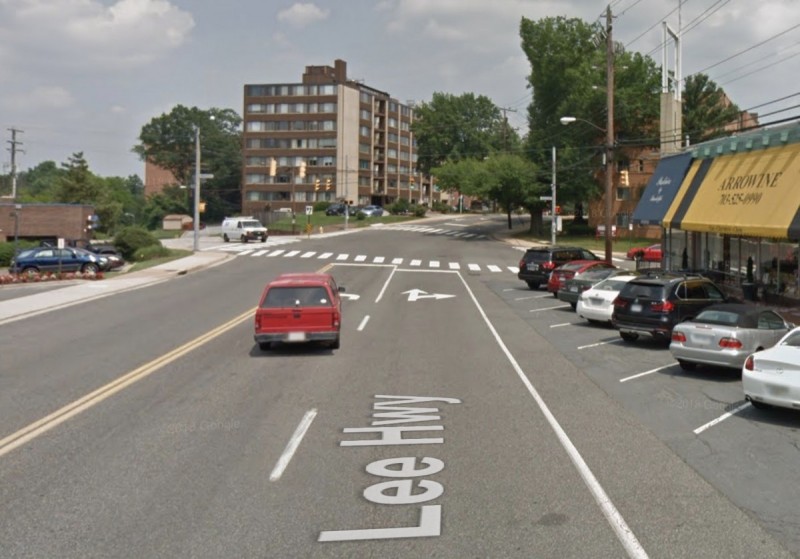
A view of Lee Heights Shopping Center on US Route 29 in Arlington. Image created with Google Maps.
Arlington county wants to overhaul US Route 29, a vital corridor that serves as North Arlington’s main street. The project is in the early stages, and there’s a lot of opportunity for residents to shape how it unfolds.
US Route 29 has another name—Lee Highway—titled after a man who fought for the power of human beings to own other human beings. (GGWash style guide policy is to use local names except when they memorialize Confederate soldiers.)
What’s the future of US Route 29?
Fifty years ago, Arlington County planned a corridor. The Orange Line was about to be finished, stitching together a string of communities that had grown up along the Washington, Arlington, and Falls Church Railway (WA&FC) streetcar line decades before.
The county seized its chance, and came together to make a plan for the corridor’s future. That plan, to embrace and concentrate development along the Metro line, is famous in the history of smart growth. It has won the American Planning Association’s national award for implementation. But now, with population and economic stress rising far beyond the expectations of the early 1970s, the Orange Line may not be enough.
Today, Arlington has another once-in-a-generation corridor to plan.
US Route 29 follows a path that once belonged to the W&OD Great Falls Division streetcar, and, like the Orange Line, it passes through a number of traditional town centers on its way from east to west (check out this old video!). Now, for the first time in the county’s history, it is holding a community process to plan a comprehensive future for all 4.2 miles of the corridor.
A 2016 rendering of Lee Heights by the Lee Highway Alliance. 
Nobody knows yet what that future will mean. The county has its goals – multimodal transportation, sustainability, affordable housing, cultural preservation – but those goals are ambiguous. Multimodal transportation could mean another mile of unprotected bike lanes, or it could mean an entire corridor of dedicated Bus Rapid Transit (BRT) with buses coming every few minutes.
Affordable housing could mean whole neighborhoods of dense, walkable, human-scale housing for mixed incomes, or it could mean a handful of backyard cottages scattered throughout the corridor. The choice between those futures relies on loud, active, committed engagement from people like you.
You can get involved with planning this important corridor
I’m the Youth Advocacy Representative on the Plan Lee Highway Community Forum, which is a group of 53 stakeholders from the corridor. We regularly attend planning meetings, where our purpose is to serve as a conduit between the community and the planners. For me, that also means many things, including working with the Lee Highway Alliance, a community group, to introduce urban planning into the 7th-grade curriculum of a local school.
A map of the study area along US Route 29 by the Lee Highway Alliance. 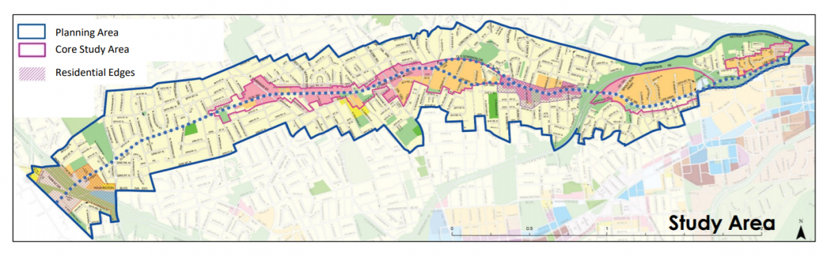
Over the last year, these planners have prepared a report on the existing conditions along the US Route 29 corridor that was released a few weeks ago. It describes the current state of the street and its surrounding communities in great detail.
In the new year, the professional team will begin guiding the community in laying out a plan for the corridor’s next 30 years. Arlington is known for extensive and very slow community engagement, and the planning process will probably take at least two more years. The push for a more progressive, inclusive, sustainable US Route 29 must be perseverant.
One of the clear conclusions of the existing conditions report is how US Route 29, as it currently exists, is structured around a series of distinct nodes. The street does not form a consistent environment along its entire length, but rather passes, wavelike, through peaks and valleys of intensity (as well as literal peaks and valleys—Arlington is hilly).
Another conclusion is that, especially as Crystal City grows as an employment center, north-south transportation within Arlington will be just as important as east-west connections to DC and Fairfax.
Get engaged and stay engaged
If you live in the corridor, work there, go to school there, commute there, or hang out in the parking lots of the 7-11s there, you’re a stakeholder. If you might want to live there someday, but the price of housing is an obstacle, you’re a stakeholder. If you’re the descendant of someone who was barred from living along Lee Highway by exclusionary zoning, you’re a stakeholder.
There are a few ways you can be involved:
- Get on the Plan Lee Highway email list, and maybe also the Lee Highway Alliance email list, to stay up-to-date and hear about events.
- Fill out this survey to share your perspective with Arlington staff (before November 30th!)
- Take a look at the existing conditions report
- Attend the Open Design Studio workshop on Friday, December 9, from 12-3 pm.
- Best of all, reach out to me – I’d love to hear what you have to say. I would especially love to hear from you if you’re young (under 30) or have a child who is interested in the planning process.
A note on names
While Lee Highway is the name most locals still use for US Route 29, Arlington has lately been shedding some of its more visible Confederate symbols. The street only got its current name in the 1920s, 60 years after the Civil War. Before then it was the “Georgetown & Fairfax Road. A neighborhood high school with the same former namesake recently became Washington and Liberty. Route 1, in Crystal City, was changed from Jefferson Davis Highway to Richmond Highway in September.
Pessimists often argue that it will be hard to change Lee Highway’s name because the street is owned by the Virginia Department of Transportation – but then, VDOT also owns Route 1. It’s worth remembering that the county’s own name can be seen as a celebration of that same slaveholding general: Arlington House was the Lee family’s inherited estate.