Do Arlington’s new bike projects hold up to the ambitious plans it recently passed?

Person biking on the Crystal City Connector by Elvert Barnes licensed under Creative Commons.
Arlington wants to make it safer, easier, and more pleasant to get around by bike, but recent projects don’t quite live up to the county’s stated goals. In April, the Arlington County Board unanimously adopted a revised Bicycle Element for its Master Transportation Plan. Their vision is for bicycling to be “an integral part of Arlington’s equitable, multimodal transportation system” and to provide “safe, reliable, convenient and comfortable travel for persons of all ages and abilities.”
The new plan envisions the county connected by network of low-stress bicycle routes (meaning people biking feel safe), and it identified specific projects needed to build it out. Importantly, the Board amended the draft to specify that “the minimum acceptable facility” for the network’s projects would be selected according to the National Association of City Transportation Officials’ (NACTO) guidance, which are generally better quality than what jurisdictions otherwise install.
The adopted Bike Element is, with the Board’s change, excellent. (Full disclosure: I served on the Working Group that advised staff on the Plan.) Within weeks of adoption, Arlington was ranked fifth in People for Bikes’ city rankings, and was the highest-ranking jurisdiction in the Washington region. The release specifically cited the newly-adopted Bike Element for Arlington’s rise.
Since April, Arlington has reached out the public to get feedback on four new bike projects in various phases of design. However, the plans they presented offer a mixed picture of how Arlington County staff is actually implementing the Bike Element. Here’s a rundown of the four projects the county has put forward.
Locations of the four bike projects in Arlington. Image created with Google Maps. 
1. North Quincy Street (Ballston-Cherrydale Multimodal Safety Improvements)
North Quincy Street is a minor arterial that connects the Custis Trail to Ballston. A bike path there would create a critical North-South connection through the middle of the county, something that’s currently missing from Arlington’s low-stress bike network.
The Bike Element identifies this street as a Priority Bicycling Corridor and calls for protected bike lanes here. Since 2015, WABA’ Bike Friendly Ballston Campaign has been calling for protected bike lanes on Quincy from Glebe to the Custis Trail. In 2018, Arlington installed protected bike lanes from Glebe Road to 9th Street North, to rave reviews.
A child bicycles in a protected bike lane on Quincy Street installed last year. Image by the author.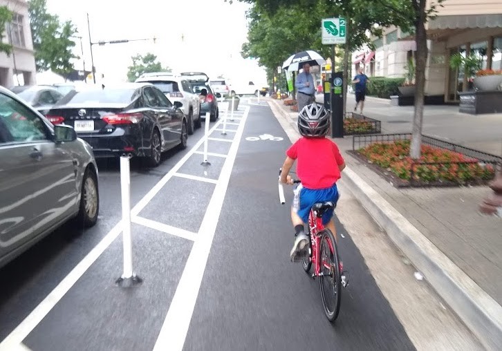
The county is repaving the roadway from Fairfax Drive to 13th Street North this year, and will repave from 13th Street North to the Custis Trail in 2021. Both projects give staff the opportunity to reallocate road space through striping. (Technically, this project only includes funds for painted lanes, but they can easily be converted to protected ones later.)
In June, staff presented three options for the entire stretch, but none of the options had protected bike lanes on every block. Then on Tuesday, staff presented their preferred concept. It’s excellent south of Washington Boulevard, and would create a continuous, low-stress route in an area with a lot of homes and places to shop and improves many of the pedestrian crossings of Quincy Street.
North of Washington though, it would leave a gap in the network to preserve residential permit parking and parking for events at Washington-Liberty High School. Staff say they are required to preserve residential permit parking because of a County Board moratorium on changes. Event parking is used about once a week, though ample parking is available in the high school’s parking deck and on side streets.
Because the stretch north of 13th Street will not be redone until 2021, it would be possible for Arlington to go ahead with the preferred concept now and create a fully-protected route in two years. Under this scenario, this year Quincy would get continuous bike lanes north of Washington Boulevard where bike lanes currently disappear, which would be a huge improvement.
There is still time for staff to make changes to this plan, either by improving what is installed this year or by committing to a better route in 2021. Arlington County is accepting comments on the preferred concept via an online form until Friday, July 17.
2. Army Navy Drive Complete Street in Pentagon City
Army Navy Road is a major arterial that runs along the northern end of National Landing, connecting Pentagon City to Crystal City. The street is very wide—currently seven total lanes of asphalt—and it’s inhospitable to people walking and biking, which also hurts the experience of those taking transit.
Arlington County has a long-planned major capital project for Army Navy between 12th Street South and South Joyce Street to improve how it serves people walking and biking. In June, staff released their 30% complete draft design. Construction is planned for 2021-2023.
Army Navy Drive improvements by Arlington County.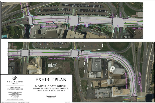
This stretch is designated a Priority Bicycling Corridor in the Bike Element. Due to the speed and volume of traffic, it requires protected infrastructure. Happily, plans include a two-way protected bikeway on the south side of the street along the entire route, as well as protected intersections. This project includes funding for full concrete protection.
Staff clearly put a lot of thought into how the bikeway interacts with every potential conflict point, and overall it looks like it will be safe and comfortable for all ages and abilities. The draft could be improved marginally by including more protection at intersections and more room for cyclists to transition to the protected bike lanes on Eads Road and to the sidepaths along 12th Street South (as suggested by this Twitter thread). Overall, though, staff should be commended.
Arlington County is accepting feedback on this design. The survey is open until Friday, July 12.
3. Lorcom Lane and N. Military Road Improvements in Cherrydale/Donaldson Run
North Lorcom Lane and North Military Road along with Old Dominion Drive form a triangle around the newly-renamed Dorothy Hamm Middle School. The county is repaving two sides of this triangle, presenting another opportunity to reallocate space for bikes with new paint. In June, staff presented a draft plan for Lorcom Lane and two options for Military Road.
Both of these streets see a lot of traffic, so bicycle lanes must be protected. The Bike Element identifies Military Road as part of a Priority Bicycling Corridor that should have low stress infrastructure, and calls for bike lanes on Lorcom to connect to North Woodstock Street south of Old Dominion.
Military Road , looking north from Old Dominion. Image by the author.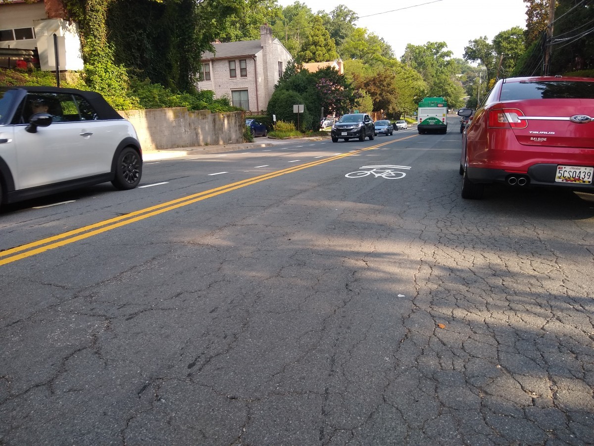
On Lorcom, there is currently a bike lane alongside parking for part of the stretch and along the sidewalk for the rest on the northbound side, which runs downhill. It has sharrows along parking on the southbound side, which runs uphill. Southbound at the intersection with Old Dominion, there are two unmarked travel lanes and one right turn only lane. This street is lined with single family homes, which all have driveways.
The draft plan for Lorcom would switch the bike lane to the uphill, southbound side, and sharrows to the downhill, northbound side. The bike lane would end at the short block before the intersection with Old Dominion, where there would be left turn, straight, and right turn lanes in the southbound roadway. For the stretch where there is no parking on the northbound side, the sidewalk would abut the travel lane.
On Military from Old Dominion to Vacation, there is currently a bike lane southbound, which is uphill, and sharrows northbound, which is downhill. From Vacation to Lorcom there are no bike markings. Street parking is allowed on both sides of the street for most of this stretch. This street is mostly lined with single family homes with driveways, but also includes some townhomes, the Cherrydale Library, and two churches with large parking lots on either side at the northern end.
Both options for Military would include significant improvements for pedestrians by marking crosswalks and stop lines that are currently unmarked, but neither would create any low-stress bicycle infrastructure. Between Old Dominion and Vacation Lane, both options would restripe the current uphill, southbound bike lane and downhill, northbound sharrows, including approximately the same amount of parking.
From Vacation Lane to Lorcom, option 1 would include downhill, southbound sharrows and an uphill, northbound bike lane, including approximately the same amount of parking. Option 2 would include bike lanes in both directions, allowing for less parking on the northbound side.
None of the draft plans for Military or Lorcom are consistent with Bike Element guidelines. Arlington could created buffered bike lanes if less space were allocated for parking. Staff noted that the county has not figured out the operational issues like trash and leaf collection with protected bike lanes beside single-family homes, though it’s not clear why a painted bike lane would pose a problem. Nor is it clear why staff did not propose protected bike lanes where both sides of the street are adjacent to churches.
On Lorcom, it is unclear why the draft plan does not include a bike lane that would connect south of Old Dominion to Woodstock Street, as called for in the Bike Element. It is surprising that a bicycle friendly community would be planning for sharrows on a high volume street in 2019.
Arlington County is accepting feedback on this design until Friday, July 12.
4. Fifth Road South Roadway Enhancements in Glencarlyn
Fifth Road South, which runs by the entrance to Carlin Springs Elementary School, is a key connection between Arlington and the Bailey’s Crossroads area of Fairfax County. The county is currently repaving this street too, and in June, staff presented a draft remarking plan.
Draft remarking plan by Arlington County.
This street also sees a lot of traffic and therefore needs protected biycle infrastructure. This street is very wide, and currently has one lane and plus parking headed west, and two travel lanes headed east.
The draft remarking plan would include buffered bike lanes against the curb eastbound and outside of parking westbound. (Parking would only be allowed on the westbound side.) While the eastbound bike lanes would be low-stress, the westbound bike lanes would not. The space exists on this street to put the parking outside of the bike lane, creating a protected westbound bike lane.
Fifth Road South. Image created with Google Maps. 
Comments for this project can be emailed to county staff: dnabors@arlingtonva.us & kobrien@arlingtonva.us.
So what’s the overall picture of Arlington’s new bike projects?
When looking at these four projects for consistency with the Bike Element and whether they would actually create a low-stress bicycle network, we see a mixed bag.
The future of bicycling. Image by the author.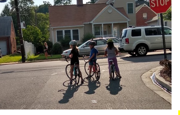
On Army Navy Drive, the draft design is consistent with the county’s vision. On Quincy and on Fifth Street South, the preferred concept could be better, but could eventually create a connected low stress network. However, on Lorcom and Military, the staff drafts would not create even unconnected bits of low-stress infrastructure—even on a priority bicycling corridor, and even where the road is not adjacent to single-family homes.
Arlington depends on these piecemeal projects to build out its bicycle network. However, if it does not install low-stress infrastructure when it has the opportunity, then the network will never be built, and the lofty goals and vision of the Bicycle Element will simply be words on a page.