DDOT defines Met Branch Trail options to the north
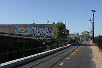
Photo by TrailVoice on Flickr.
DDOT took a big step toward continuing the Metropolitan Branch Trail when it released a draft Environmental Assessment this month. This examines the places the trail will utilizes National Park Service: the section from Kansas Avenue to Catholic University, the Prince George’s County Connector and the section from Van Buren Street to the District line.
In each area, the trail would be 10-12 feet wide where possible and built as a separate path. There would be waysides and seating available at key points, such as overlooking the Fort Totten Metro tunnel. DDOT would assume maintenance and costs for the trail.
The report is the first look into the trail’s potential route that the public has seen in a few years.
From it’s current terminus at the north end of John McCormack Drive NE to Riggs Road, there is only one proposed route. The trail would pass between the trash transfer station/concrete plant and the railroad tracks. There is currently an open culvert there and that would be encased so that the trail would pass over it.
It would then go over the Metro tunnel just west of the Ft. Totten station. The trail would descend down the hill, at a slope meeting ADA standards if practical, to the west side of 1st Pl. Additionally, a set of stairs with rolling grooves is also proposed to provide a direct connection to the Metro.
Along First Pl, the trail would travel along a widened sidewalk or parallel trail to Riggs Road. It would cross Riggs Road at grade (no bridge as originally proposed) and go west along Riggs Road on an improved sidewalk.
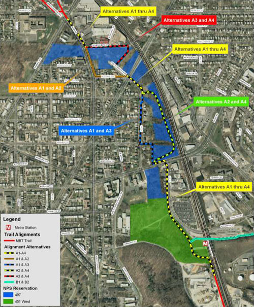
Alternatives around Fort Totten.
At the end of the retaining wall along Riggs Road the trail would do one of two things:
- In two alternatives (A1 and A3) it would go north just behind the houses on 1st St. NE to Kennedy St. Then it would become an on-street route using Kennedy, 1st and South Dakota Ave. to cross New Hampshire Ave.
- In the other two alternatives (A2 and A4) it would run closer to the railroad tracks and connect to 1st St. NE just north of Madison St. It would then cross New Hampshire at South Dakota Ave.
Across New Hampshire there are again two options:
- An on-street or on-sidewalk route along MacDonald place to Blair Road and then north on a sidepath along Blair
- Continuing east of the community garden as a path to Oglethorpe St NE, then west to Blair and north on Blair.
 Alternatives around Takoma.
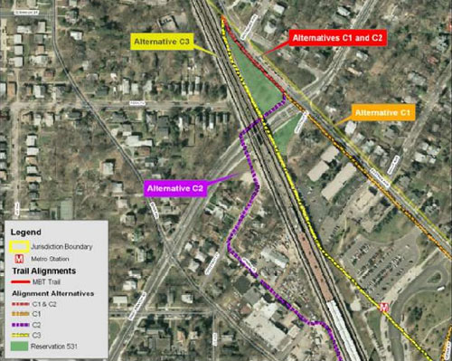
The trail then follows Blair to Van Buren Street. At this point, there are four options:
- A sidepath east (C1) along Van Buren St, Sandy Spring Road, Maple St., Carol St., Cedar St. and Eastern Avenue to the District line at Takoma Avenue. This option crosses Piney Branch Road at grade.
- A sidepath west (C2-bridge) along Van Buren St, 4th Street, Blair Rd and Chestnut street with a bridge over Piney Branch Rd. Then along the sidewalk along Piney Branch’s north side. At Eastern Avenue turn north on a sidepath to the District line at Takoma Avenue.
- A sidepath west (C2-no bridge) along Van Buren St, 4th Street, Blair Rd and Chestnut street with a switchback down to Piney Branch Rd. Then along the sidewalk along Piney Branch’s south side. At Eastern Avenue, cross Piney Branch at grade and follow Eastern to the District line at Takoma Avenue.
- A sidepath east (C3) along Van Buren St, Sandy Spring Road, Maple St. and Carol St. to the Takoma Metro station. Then onto an elevated structure that crosses Metro property and the driveway to run parallel to the tracks, between them and the apartments. It would go over Piney Branch on a bridge east of the railroad bridge. And then along the edge of the Cady-Lee mansion property parallel to the tracks to the District Line at Takoma Avenue. This alignment is new to the discussion.
Additionally, the EA lays out the options for the DC section of the Prince George’s County connector.
That trail proceeds from the Ft. Totten station to South Dakota Ave on a route yet to be decided. It crosses South Dakota at grade. Then it becomes either a striped, on-street route (B2) or a sidepath (B1) along Gallatin Rd. Finally it connects to a new 220 foot long trail from Gallatin Street across NPS land to the PG County trail north of St Ann’s driveway.
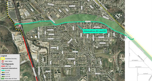
Alternatives for the Prince George’s County connector.
The environmental impacts described in the report are mostly negligible or minor. Some A and B alternatives involve cutting down trees or removing vegetation. One C alternative might interfere with views of the Cady-Lee Mansion.
The best options are the ones that make the trail straightest and easiest, limiting at-grade crossings of busy streets and giving cyclists the option to get off road (since on-road options will always remain). Options A2, B1 and C3 best achieve those goals. However, it is likely that they cost more than other options.
Comments may be submitted by email at heather.deutsch@dc.gov or by mail at the following address:
Heather Deutsch, Trail Planner,
Planning, Policy and Sustainability Administration,
District Department of Transportation,
2000 14th Street, NW, 7th Floor,
Washington, DC 20009
Comments must be received no later than December 15, 2010.
Cross-posted at The Washcycle.