2017’s greatest hits: How segregation shaped DC’s northernmost ward
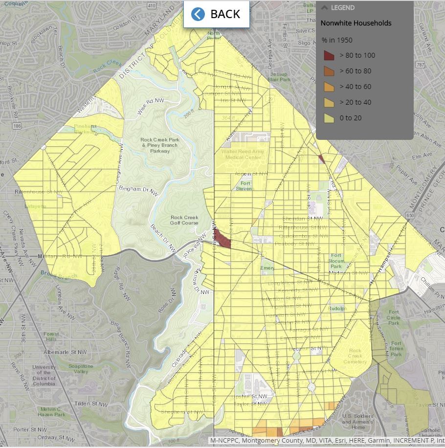
Image by Prologue DC, all maps by Brian Kraft/JMT, data courtesy of US Census Bureau.
To close out 2017, we’re reposting some of the most popular and still-relevant articles from the year. This post originally ran on September 14. Enjoy and happy New Year!
DC’s Ward 4 is today home to numerous racially diverse neighborhoods–including Petworth, Brightwood, Takoma and Shepherd Park–despite the area's history of segregation. When this part of the city was first developed, much of its housing was legally required to be occupied solely by white residents.
Prologue DC’s online public history project “Mapping Segregation in Washington DC” is documenting the historic extent of racially restrictive deed covenants that kept much of the city off-limits to African Americans during the first half of the 20th century. Its latest installment focuses on the city’s northernmost ward.
Racially restricted lots. Image by Prologue DC. Data courtesy of DC Archives, DC Recorder of Deeds and DC Historic Preservation Office.
Segregated neighborhoods replaced rural black enclaves
At the turn of the 20th century, the rural area north of Washington’s former boundary at Florida Avenue remained largely undeveloped, but as neighborhoods close to downtown filled with row houses and transportation improved, the city’s outskirts beckoned. Although largely undeveloped, the area comprising today’s Ward 4—from Spring and Rock Creek Church roads all the way to the city line at Eastern Avenue—was then home to several African American communities. Around Fort Stevens in Brightwood, black residents owned at least 25 acres of land, with at least one family dating to 1837. African Americans also lived around Fort Slocum and Fort Totten, which were among the sites to which newly arrived black Washingtonians had migrated during the Civil War and remained into the 1930's.
As new housing went up in what was then known as North Washington, many of the area’s most prolific developers included racial covenants in the deeds, prohibiting occupancy by African Americans, and in some cases by Jews or other so-called Semitic groups. In Petworth and other neighborhoods throughout DC, whites-only citizens associations later worked to add racial restrictions to deeds that did not already contain them.
Racially restricted lots. Image by Prologue DC. Data courtesy of DC Archives, DC Recorder of Deeds, and DC Historic Preservation Office.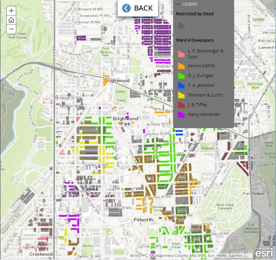
In addition to individual properties, numerous entire subdivisions were racially restricted in their entirety prior to development. North Washington’s historically black enclaves eventually disappeared as a result.
Segregation led to white flight
By establishing certain neighborhoods as exclusively white and confining African Americans to other areas, racial covenants laid the groundwork for local and federal housing policies that institutionalized spatial segregation. The Federal Housing Administration included racial deed covenants, and the proximity of whites-only schools, as criteria for underwriting mortgages, while DC’s local housing authority developed segregated apartments in areas where both African Americans and white people lived.
After a decades-long battle by the NAACP and local civil rights attorneys in cities across the US—Mapping Segregation’s first installment documents how that played out in DC—the Supreme Court finally ruled racial covenants unenforceable and black home seekers started moving to Ward 4’s southernmost blocks.
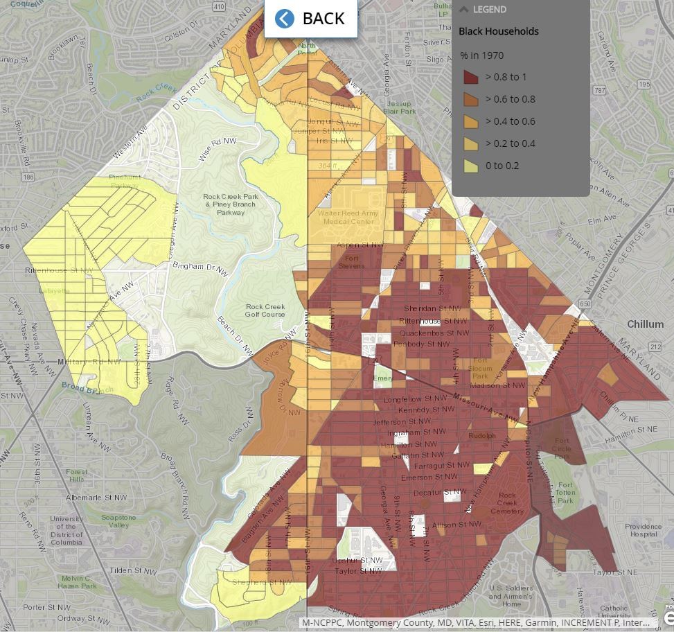
Links to oral history clips and archival documents show how real estate companies pressured white homeowners to sell by sowing fear that property values would crash. White flight accelerated after public schools desegregated in 1954. As black demand for housing in Ward 4 increased, landlords pushed out white tenants and raised rents. The resulting demographic changes are illustrated in a series of maps showing the shifting racial composition of each square block: much of Ward 4 transformed from exclusively white to entirely black over the course of just 20 years.
Households in the District mapped by race in 1950. Image by Prologue DC. Data courtesy of US Census Bureau. Households in the District mapped by race in 1970. Image by Prologue DC. Data courtesy of US Census Bureau and NHGIS.org.
The legacy of racial covenants
By creating racial boundaries and driving up black demand for housing, covenants artificially inflated the cost of housing for African Americans. Covenants also assigned value to properties and to entire neighborhoods based on their occupants' race, so while home prices for black buyers exceeded those for whites, the market value of their property declined as soon as they moved in. The ensuing decades of disinvestment in these neighborhoods–combined with discriminatory lending practices and other factors–made these same areas ripe for gentrification today.
The federal government’s color-coded HOLC maps, made in the 1930's and now available online, ossified the patterns established by covenants. A new study by the National Community Reinvestment Coalition shows that in some cities, the same places that these so-called “redlining” maps designated as “hazardous” for mortgage lending are now the hottest neighborhoods for real estate investors and developers. Relatively affordable rents and home prices have also made areas like Petworth attractive to new white residents, who can count on values going up as they move in.