The Army nixes a land swap deal with Arlington County that would expand Arlington Cemetery

The former Navy Annex site sits between the Foxcroft neighborhood and the Air Force Memorial. Image by U.S. Army Corps of Engineers Norfolk District licensed under Creative Commons.
Last month, Arlington County announced that the Army had decided to opt out of a planned land exchange that could have given the county a plot of land near the Pentagon, after years of negotiations. Here’s what that means for the future of the site and of development along Columbia Pike.
This is a project that’s been going on for a while
The land in question mainly concerns the site of the former Navy Annex, which was built in 1941 as overflow office space for the nearby Pentagon and housed Headquarters Marine Corps (HQMC) for decades. Since the demolition of the Navy Annex building in 2012-2013, the site has sat unused. Columbia Pike, one of Arlington’s busiest thoroughfares, now passes through mostly vacant land from Oak Street South until it reaches its end at the Pentagon parking lot.
Arlington County had been pursuing a land exchange with the Army since the demolition. The County owns the right-of-way of Southgate Road, which divides the Navy Annex site from the current southern boundary of Arlington National Cemetery. Initially, the Army declared that it intended to purchase the Southgate Road right-of-way and use the land for an additional five acres of burial space.
After this announcement, however, Arlington County offered to trade the Southgate right-of-way to the Army in exchange for the strip of land between Columbia Pike and I-395 (previous site of the Navy Annex parking lots), which would then become County land. Southgate Road would be truncated and rerouted to run parallel to Oak Street South, while the majority of its length would be demolished in order to make room for contiguous burial space that would reach all the way to Columbia Pike.
The abandoned land swap proposal, with proposed Arlington Cemetery land in yellow and Arlington County land in blue. Realigned Southgate Road in red and realigned Columbia Pike in purple. Image by Arlington County.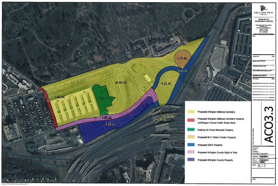
However, the Army ended up breaking off the land exchange negotiations because it wasn’t comfortable with the County’s earlier proposal to build a maintenance facility along Columbia Pike so close to the cemetery, even though that proposal died with the Columbia Pike streetcar. Arlington had hoped to put the land to a municipal use such as a fire station or a museum, alongside a commemoration of a Freedman’s Village that was once located near the site.
Site of the former Navy Annex on Columbia Pike. Image by Sam Brutcher licensed under Creative Commons.
The failure of the land swap deal means that the Army will continue with its original plans to purchase the Southgate Road right-of-way, removing a barrier to the cemetery that will now allow it to further expand onto the Navy Annex site. Now the question remains: what will happen to the proposed county land south of Columbia Pike? With the cemetery rapidly running out of space, will burial sites now be located alongside both sides of the street?
Arlington Cemetery has been pursuing large expansion projects in last several years, including the creation of more burial space along the northwestern border with Fort Myer. A Washington Post article says that turning the Navy Annex site into burial space will add space for 40,000-60,000 new graves, allowing the cemetery to handle demand until at least 2050.
Construction crews work on Arlington National Cemetery’s ongoing Millennium expansion project. Image by U.S. Army Corps of Engineers Norfolk District licensed under Creative Commons.
The downside: Less developable land in Arlington
Unfortunately, the Army’s decision to use this land for burials means that one of the last major vacant plots of land in the county is no longer available for development. Columbia Pike has seen a construction explosion in recent years, even since the cancellation of the streetcar, so it’s disappointing that this land will be going unused.
New development on Columbia Pike. Image by Brett VA licensed under Creative Commons.
Even if the county had continued with its initial plan to use the land for a fire station or maintenance facility, it could have freed up land for development elsewhere. Instead, the land alongside one of Arlington’s busiest main streets is sure to set vacant for several more years. However, the County is still requesting that the Army commemorate Freedmen’s Village somewhere along Columbia Pike near the Cemetery.
The upside: Columbia Pike realignment will go forward
Luckily, the failure of the land swap deal did not derail the long-running plans to straighten Columbia Pike near the Air Force Memorial. The project, originally proposed to coincide with the construction of the streetcar, will see the street’s intersections with Joyce Street and Route 27 completely reconfigured. A new sidewalk and 10-foot sidepath will also be constructed alongside the new section of roadway, which currently lacks pedestrian and bike facilities.
The existing curve in Columbia Pike near the Air Force Memorial. Image by Google Maps.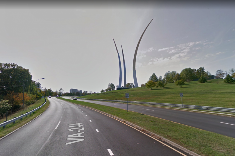
The proposed roadway realignment. Image by Arlington County.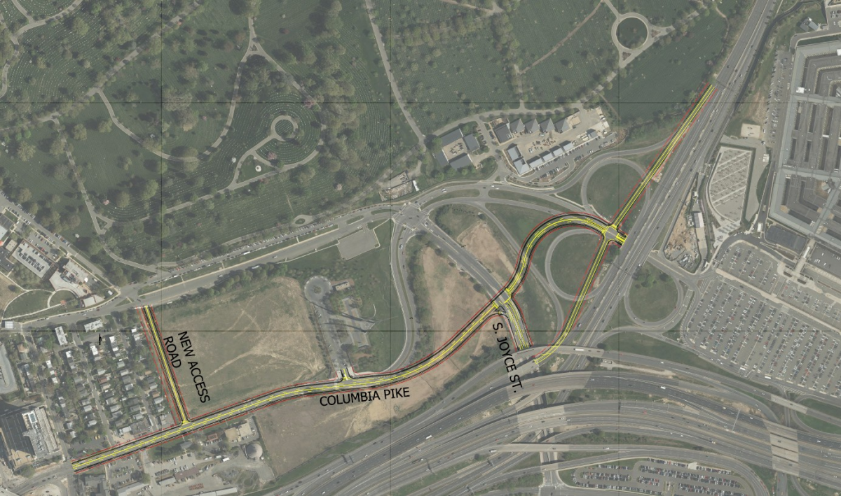
What do you think of the fallout from this deal? Let us know in the comments.