A court ruling on a Brookland development could imperil future housing near Metro stations
DC’s Court of Appeals has overturned approvals for a six-story apartment building across the street from the Brookland Metro station. The decision could give opponents in many parts of DC new ammunition to try to block new housing in their neighborhoods.
Rendering of the proposed 901 Monroe project. Image from the Menkiti Group.
Welcome to Brookland, a major front in development wars
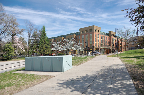
Walk out the Brookland Metro station on the neighborhood side, turn right, and after walking along the loop with bus stops you will reach Monroe Street. On the other side is a large parcel where the Colonel Brooks’ Tavern and some houses used to sit.
Now, that property, 901 Monroe Street NE, is empty. Neighbors have three times appealed, successfully, a decision by the DC Zoning Commission to allow a building with six floors, five stores, and 212 apartments.
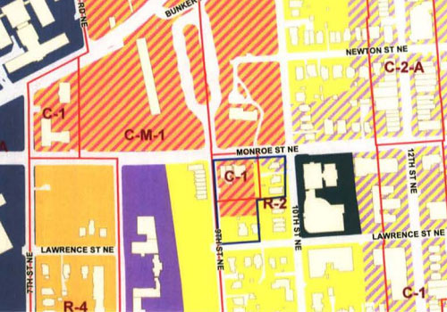
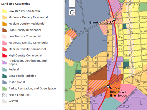
In a nutshell, a panel of judges for DC’s Court of Appeals looked a map in DC’s Comprehensive Plan, called the Future Land Use Map (FLUM). The map shows this area in shades of orange, signifying that it is “moderate density.” The definitions for the categories say that moderate density areas are generally ones with 2-4 story buildings.
This is not 2-4 stories. Therefore, the court said, it’s not reasonable to allow a taller building. For a number of reasons, the legal issue is much more complicated, but here’s the rub: There are a lot of places in the city that are orange on this map, and a lot of them have, or could soon have, buildings like this one.
Unless this ruling means that now, they may not be able to.
Once upon a time, some people wanted to build housing near Metro…
In 2010, the owners of 901 Monroe, a partnership between the Menkiti Group, Horning Brothers, and Jim Steigman, applied for a kind of zoning permission called a “Planned Unit Development.” A PUD lets a building exceed the zoning for an area in exchange for a high-quality project that provides public benefits. DC’s Zoning Commission, the hybrid federal-local board with final authority over zoning, reviews and decides on PUDs.
In 2012, the Zoning Commission approved the project. Neighbors appealed. A three-judge panel found that most of the approval was reasonable, but found some holes in the commission’s findings, which it asked the commission to fill in. The commission did so, but by copying verbatim some suggested text from the developer, and in a second appeal, a different panel of judges said that was not okay, as well as identifying some other problems with the order.
The Zoning Commission approved the project a third time, and neighbors appealed a third time. This time, the judges said the commission’s approval was not a reasonable interpretation of DC’s Comprehensive Plan at all, and overturned the zoning approvals entirely.
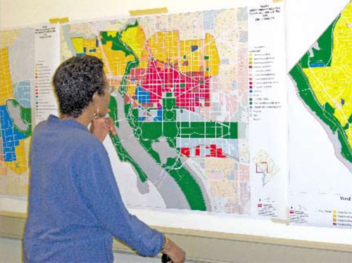
Image from the DC Comprehensive Plan.
How comprehensive is the Comprehensive Plan?
DC’s Comprehensive Plan, or “Comp Plan,” is a document written by DC’s Office of Planning and approved by the DC Council. By law, zoning decisions must be consistent with the Comp Plan.
Unfortunately, the Comp Plan is not all that consistent with itself. It contains long lists of policy statements, many vague and many pointing in different directions. It talks about the need to add housing near Metro stations but also the value of preserving single-family home neighborhoods. But what about when low-density houses surround Metro stations? The plan doesn’t say how to reconcile these conflicts.
The Zoning Commission does that. In its PUDs and other processes, it considers the various Comp Plan provisions and strikes a balance (for better or worse). Courts in DC, following a widespread legal doctrine called “deference,” generally avoid second-guessing Zoning Commission and other agency decisions if they are “not arbitrary and capricious.”
In the first of the three appeals (which is referred to as Durant I because it’s the first case brought by lead plaintiff and project neighbor Guy Durant), the court generally found the commission’s balance-striking to be acceptable.
In its report, OP [the DC Office of Planning] indicated that in its view, the developer’s proposal struck an appropriate balance between competing Plan policies, some of which encouraged new development around Metro stations, while others favored the preservation of existing neighborhoods.
[In a second, later report,] OP noted that “[t]here are elements … that support development of the site as an important link between the new commercial uses that will be developed at [a recently-approved PUD project on Catholic University’s campus] and the existing commercial uses on 12th Street. It also pointed to the existence of other, competing policies, which stressed conserving the local neighborhood’s residential character. Ultimately, OP reiterated its conclusion that the developer’s proposal struck an appropriate balance between these competing policies.
The Zoning Commission ultimately agreed, and the court in Durant I supported that approach, pointing out that:
Even if a proposal conflicts with one or more individual policies associated with the Comprehensive Plan, this does not, in and of itself, preclude the Commission from concluding that the action would be consistent with the Comprehensive Plan as a whole. The Plan is not a code of prohibitions; it is an interpretive guide, which the Commission must consider holistically. [Internal quotations omitted]
However, neighbors claimed the DC Office of Planning had misrepresented what the Future Land Use Map really said. OP’s report said that the orange striped area in the map below made up about 50% of the proposed project, while neighbors argued it was 37.5%.
The Durant I court did agree that it wasn’t clear that OP’s 50% figure was right. Maybe the Zoning Commission had been misled by OP’s report, and if so, maybe it would have made a different decision. The court couldn’t presume it would have still approved the project, so it asked the Zoning Commission to take another look. “We conclude that the Commission must explicitly resolve the FLUM designation dispute and explain whether, and how, its resolution of the issue affects its ultimate decision.”
What’s “moderate”? It’s a question that applies to more than politics
The Zoning Commission didn’t think the 37.5% versus 50% was an issue, nor were any of the other deficiencies the court had identified in Durant I. It issued a new order confirming the approval.
Neighbors appealed again. Some of the second case revolved around whether it was okay for the Zoning Commission to copy, verbatim, suggested text from the developer. But the real relevant question was whether this project qualifies as “moderate density.”
In many places in the Comprehensive Plan (including the striped area above) and a 2009 neighborhood specific plan called the Brookland Small Area Plan, the text talks about encouraging “moderate-density mixed use” or otherwise refers to allowed density as “moderate.”
Moderate density is everything that’s orange on the FLUM. The Comp Plan says moderate density areas are “characterized by a mix of single family homes, 2-4 unit buildings, row houses, and low-rise apartment buildings,” while medium density areas are “neighborhoods or areas where mid-rise (4-7 story) apartment buildings are the predominant use.”
The Brookland Small Area Plan also says that PUDs are acceptable up to a height of 50 feet in this area.
In Durant II, the court asked the Zoning Commission to better articulate why this 6-story building was “moderate density.” It did, noting among other things that the building has setbacks above 50 feet and is set away from the street in a way that would make the overall look and feel of the building fit in with a moderate-density area.
But in the third and final appeal, Durant III, the judges said, “Although those considerations are potentially relevant to other issues, they do not support a conclusion that the proposed building constitutes a moderate-density use under the FLUM, because the FLUM’s definitions of “moderate density” and “medium density” focus on buildings’ actual physical characteristics, such as the number of stories or units in a building, rather than on how the building would look to an observer.”
The opinion says that maybe the Zoning Commission could simply decide that medium density is also okay here, but since neither side asked for it to go back again for a fourth time, the court simply overturned the PUD approval. Bo Menkiti, owner of the Menkiti Group, says he and the other partners in the project are “still committed” to the project and are considering their options.
This case is making planners far more conservative
Meanwhile, however, this case has already reverberated in other proposals. Just south of Rhode Island Avenue from here, there’s a proposal to redevelop the Brookland Manor garden apartment complex into a mixed-use village with larger buildings. But the whole neighborhood is colored orange on the FLUM. The DC Office of Planning has worried that some of the buildings didn’t seem to fit with the “moderate” density label.
OP hasn’t said so outright, but there’s reason to believe this issue also was behind their refusal to allow a hearing on Georgetown Day School’s proposal for an 80-foot building in an area that’s — you guessed it — moderate density orange (and low density commercial pink) on the map.
Opponents of the proposed development at the former McMillan sand filtration plant are challenging that project in court, saying it doesn’t fit with the FLUM’s classification for the property.
It’s not uncommon for opponents of a project to bring a lawsuit, but most of them, such as the ones recently for the Hine School by Eastern Market Metro or the West End library and fire station, don’t succeeed. But Hine is seven stories at its highest point (more than 901 Monroe), yet its area on the map is orange.
It’s not a log flume, but it’s making a big splash
There is a lot of “moderate density” orange on the FLUM, including in many areas with some large apartment buildings. My block is orange, for instance, but behind my house is a large 9-story building; on the end of the block is one that’s seven stories.
Heck, the Cairo apartment building, DC’s tallest residential building, is 164 feet tall and in an orange zone on the FLUM. It sits among an area of mostly row houses, sure, but it’s sure not moderate density.
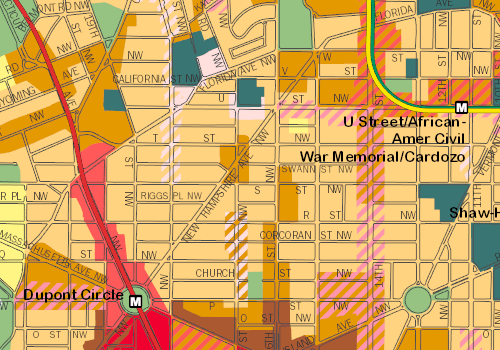
Meanwhile, on many commercial corridors, the FLUM is a patchwork of color changes from one block to the next based on the prevailing land use right now. Again just in my neighborhood, one block of 17th Street which happens to have residential buildings (and tall ones) is colored residential and not commercial. Yet if they were ever redeveloped, ground-floor retail would be a sensible element to include, since there is retail across the street.
The same principles apply across DC. The FLUM is not really a vision for what neighborhoods could become; it’s more a description of what they are now or how planners already anticipated they would change in 2006, when the map was made.
Paul Tummonds, an attorney for Goulston & Storrs which represents 901 Monroe, said, “The problem with the FLUM is that in large swaths, there was no forethought of future land use. It’s more, ‘This is what’s there now.’ I don’t think there was a real planning perspective of what should be there in the future; it was a recitation of existing conditions.”
If courts start taking the FLUM’s “this broad area will probably be moderate density” as a stricter dictate that medium-density buildings are verboten, and if OP applies that to other proposals (as it may already be doing), that’d mean a big change for the ability to add housing on major corridors and near Metro stations, housing DC desperately needs.