Make space for bikes on the GW Parkway
The George Washington Parkway was originally just supposed to help tourists get to Mount Vernon, and its keepers’ main mission is to preserve natural resources, not maintain roads. Could there be fewer driving lanes and more space for other modes of transportation?
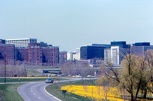
Photo by Roger W on Flickr.
The southern section of the George Washington Memorial Parkway opened to traffic in 1932. Conceived as a means to ease tourist access to George Washington’s home at Mount Vernon, it morphed throughout the latter part of the 20th century into a motorist commuter route for far-flung suburbanites heading to DC.
Both the road and the adjacent Mount Vernon Trail are maintained by the National Park Service (NPS), whose mission is to “preserve unimpaired the natural and cultural resources” of the United States. You will not find anywhere in its mission statement that it is to provide fast, convenient commuter routes for the suburbs of Washington, DC.
Average daily traffic (ADT) volumes on the parkway within the last few years have been approximately 16,000 vehicles, a number that isn’t huge but certainly lessens the road’s original scenic purpose. Birdsong is impossible to hear with the din of SUVs in the background.

Note how close the four lanes of traffic are to the trail on the right. Also, note that no crosswalks are present at this busy intersection. Nor are there any signals to stop traffic for people crossing on foot or by bike.
That ADT number is also well within the
Parallel to the four-lane parkway is the Mount Vernon Trail, a winding, narrow multiuser trail. In recent years, this trail has become a major commuter route for people who bike to and from DC. Upwards of 2000 bikes per day hit the trail, despite the trail’s narrowness.
People who walk and bike must share this trail, as signs along the road prohibit bicycles from the road. Interestingly, the federal code governing the road’s usagedoesn’t reference bicycles explicitly. Nor does the code prohibit changes to the amount of space on the roadway given over to motorists.
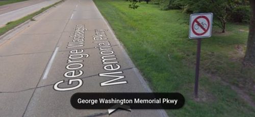
Bikes are not allowed on the lightly-traveled GW Parkway. Instead, they are forced onto the adjacent Mount Vernon Trail.
Recently, the National Park Service released its National Capital Region Draft Paved Trail Study for comment. The study is an update of the 1990 plan written in an era when bicycling in the US was less of an everyday transportation mode and more of a recreational activity. The plan tends to view the trails in isolation. There’s no mention of what mode will get priority when there is conflict, such as when people on bikes or on foot must cross the road for access to trails. It also does not address the feasibility of road diets that would balance out mode space on routes like the southern section of the parkway.
Does it make sense that cars on the southern section (below Alexandria) of the parkway are given four lanes of space while bikes and pedestrians are crammed onto the narrow, winding MVT? Both are major commuter routes, but whereas the MVT is overcrowded at 2000 ADT, the parkway is half-empty at 16,000 ADT. In essence, the trail is under-built, while the road is over-built.
This is the George Washington Memorial Parkway today: four high-speed lanes, no traffic lights, controlled access, and a narrow multiuser trail parallel to the roadway. All of this is next to the Potomac River. All images from the Virginia Bicycling Federation.
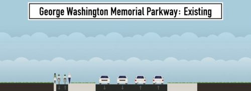
If the draft paved trail plan truly acknowledged the modern and future needs of this particular route, discussion of a road diet on the GW Parkway would be on the table. The road could easily be shrunk to one vehicle lane in each direction with adjacent buffered bike lanes. The MVT could be given over entirely to people who walk, eliminating potentially hazardous bike-pedestrian conflicts.

A road diet on the parkway would leave two lanes for motorists, buffered bike lanes on the remaining space, and leave the Mount Vernon Trail exclusively for use by those on foot.
This is not without precedent. In 2001 the state of New York closed two out of four lanes on the Robert Moses Parkway in the Niagara Falls region. As with the GW Parkway, this highway was controlled access with an eye towards enhancing tourist traffic while providing access to scenic beauty. Instead, it proved to be such a failure in all regards that local advocates didn’t stop with a road diet. They pushed through a plan to remove it entirely for at least a two mile stretch. If the state of New York can pull this off, despite actually having a mandate to provide speedy transportation options, why can’t the National Park Service?
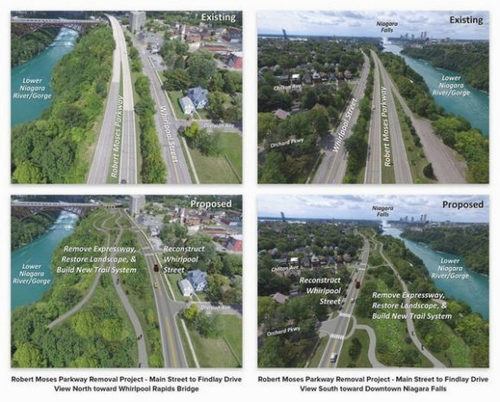
The Robert Moses Parkway in the Niagara River region was very similar to the George Washington Parkway, until a road diet was implemented. Now a two-mile portion will be removed to allow better river access.
NPS has an opportunity to shift its focus in the National Capital region away from an old-school, road-centric mindset to a more sustainable approach that also recognizes the changing commuter habits of younger generations. If you agree, send the National Park Service your comments via their comment page. You have until May 19th to do so. After that, you may have to wait another quarter-century to get your input to them.
This post originally ran on the Virginia Bicycling Federation’s blog.