Work on the Rock Creek Park Trail will fulfill a long-ago promise
Two complementary projects starting in the near future promise to completely change the bike trails in Rock Creek Park. Both will address trail issues first raised over 20 years ago.

Photo by TrailVoice on Flickr.
The first project will rebuild Beach Drive and 1.5 miles of the 5.9 mile trail that runs alongside it. It will reconfigure the part of the trail that runs through the tunnel that goes under the National Zoo, build a new bridge over Rock Creek, and reshape the trail’s intersection with Shoreham Drive. It should start this year, and finish in 2018.
Meanwhile, the District Department of Transportation wants to start a complementary project in the spring of 2017 that will build one new mile of trail within Rock Creek Park and rehabilitate another 3.5 miles of trail.
This project has been a long time coming. It was first publicly announced in October 2005, at which time work was to start in January 2007 and be finished by the end of that year, but since DDOT and the NPS couldn’t agree on some details, it’s been delayed. But it actually goes back even further: Many of the problems it’s hoping to address (along with some the FHWA project will address) were first identified all the way back in 1990, in a National Park Service report called “Paved Trails of the National Capitol Region.” That plan is currently being updated.
But at the Bicycle Advisory Council’s March Meeting, DDOT’s Michael Alvino said the project is moving forward. A rebuilt and expanded Rock Creek Trail promises to make the trail safer and and more useful. Here’s a rundown of the specifics:
Rose Park and the P Street Ramp
Rose Park is on the east side of Georgetown, south of P Street and east of 27th. On the east side of the park there is a trail, about 40 feet above the parallel Rock Creek Park Trail (RCPT), called the Rose Park Trail. From M and 28th to P and 25th, that trail will be widened by about one foot, making it about six feet wide.
From the northern end of the Rose Park Trail, a ramp connects P Street to the Rock Creek and Potomac Parkway.
This project will add trails to both sides of the ramp.

Trail at the P Street Ramp. All images from DDOT unless otherwise noted.
The Devil’s Chair
The Devil’s Chair Bridge just north of Q street requires trail users to make two quick 90 degree turns to cross Rock Creek. While it won’t be realigned, it will get a wider curve on the Mt. Zion cemetery side. Also, the fenced in landing on the opposite side will be replaced with a curved approach.
The north landing of the Devil’s Chair Bridge.
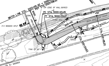
Trail straightening
DDOT will straighten the trail in several places. One example of what this looks like is below the Calvert Street Bridge, where the trail curve has resulted in a well-worn desire line. Realizing the people have spoken, DDOT will make the desire line the new trail, and the curved portion will be removed.
Straightened Rock Creek Trail beneath Calvert Street.
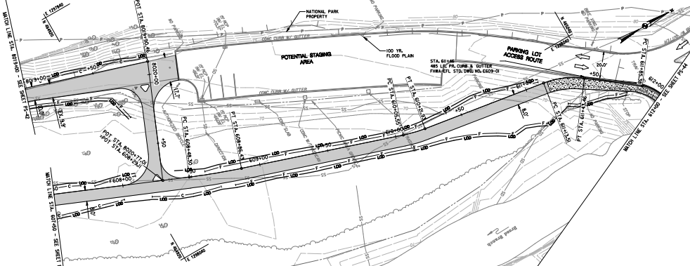
New access to Harvard Street
Between Cathedral Avenue and Klingle Road, a distance of about a mile, the only trail access point is Zoo Drive, just south of Harvard Street. Zoo Drive gives trail users a roundabout access to Harvard Street, but only when the Zoo is open. The trail project will create new, more direct access to Harvard Street, via a route that is not impacted by Zoo hours. A small trail spur will connect to a crosswalk across Beach Drive. On the other side of Beach, trail users can connect to Harvard Street at Adams Mill Road via a five foot wide ramp. Part of the ramp can be bypassed by a set of stairs with a bicycle runner.

New trail connection to Harvard Street.
Paved desire line north of Tilden
Just north of Tilden, the current trail splits in two. A paved trail connects to the parking lot off Broad Branch Road and a desire line leads to the current crosswalk. DDOT will pave the desire line, connect the two trails and create a new curb ramp at the existing crosswalk across Broad Branch.
Twin trails between Broad Branch and Tilden.
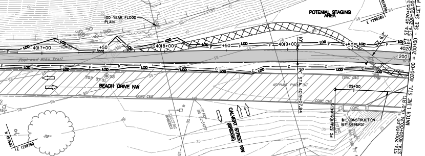
Improved Beach/Blagden/Broad Branch intersection
The double intersection of Beach Drive with Blagden Avenue on one side of Rock Creek and Broad Branch on the other side will be reworked to make it safer for trail users, and to create a better connection to the trail along the south side of Blagden Street.
The new intersection will remove the slip lane from Beach to Blagdon to slow down turning vehicles. Three new crosswalks with curb ramps and new sidewalk on the east side of Beach will connect the RCPT to the trail along Blagden. Another curb ramp will connect the end of the RCPT to Beach.

New Beach Road intersections with Blagden and Broad Branch.
New trail along Piney Branch Parkway
In addition to improving miles of existing trail, DDOT will build about one mile of trail along Piney Branch Parkway. Connecting, via a crosswalk across Beach, to a new section of trail that the FHWA will construct adjacent to Beach Drive, the Piney Branch Trail will climb up to Arkansas Avenue on the north side of Piney Branch Parkway, passing under 16th Street on the way.
Once at Arkansas Avenue, DDOT will extend the trail east to Taylor Street and west to 16th Street.
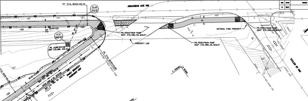
Piney Branch Trail terminus at Arkansas Avenue.
Klingle Road connection
The current trail spur to Klingle Drive will be removed and a new one will replace it about 10 feet closer to Rock Creek. This will allow DDOT to install two new crosswalks to the sidewalk on the other side of Klingle and use the existing median as a pedestrian refuge. The sidewalk along Klingle will also be improved, connecting to the new FHWA-built section of trail along Beach to the Piney Branch Trail.
Crosswalk to Klingle Road Sidewalk.
As comprehensive as these projects are, and as much of an improvement as they represent, they — and other ongoing or previously completed projects — still don’t address all the needs identified in the 1990 Paved Trails report. In fact only one of the four “high priority” projects have been completed. We still need a complete trail between Broad Branch and the Maryland boundary, a re-design of Zoo security “so that the streamside trail can be used 24 hours a day all year”, and a trail along Broad Branch (though a plan to install a sidewalk and bike lane is scheduled for construction in 2019).
Since the Klingle Valley Trail is currently underway, there is only one unaddressed medium priority project: using the Lover’s Lane path to connect the trail to Massachusetts Avenue.
Finally, the three unaddressed low priority projects are a trail from W Street and 44th to Rock Creek via the Whitehaven Parkway and Dumbarton Oaks Park, rehabilitation of the Oregon Avenue/Bingham Road loop and the addition of a trail along Park Road NW from Beach Road to the Piney Branch Parkway.
Still, this project represents a major step towards the fulfillment of that plan.