Reston wants urban street grids around future Metro stations
Fairfax County wants to make it easier to walk, bike, and drive in Reston, especially to current and planned Silver Line stations. A new street grid and three ways to cross the Dulles Toll Road are part of the plan to make that happen.
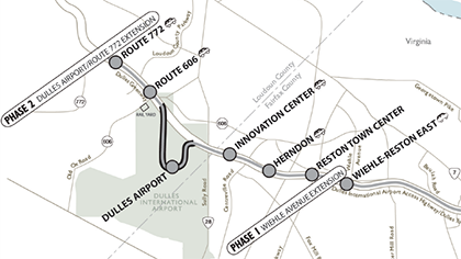
Image from Fairfax County
The county’s Department of Transportation recently kicked off the Reston Network Analysis, which is focused on finalizing the grid of streets necessary to support the coming development around three new Metro stations in Reston.
Ideas for near the stations include new bike lanes, adjusted traffic signals, and re-striped roads, as well as realigned or wider roads. It’s also possible that Fairfax will build new roads in these areas.
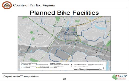
Proposed bike facilities in Reston. Image from Fairfax County.
One of the Reston-wide improvements is the Soapstone Drive Overpass , which will provide another connection across the Dulles Toll Road and a new way to get to the Wiehle-Reston East station.
There will also be a Town Center Parkway Underpass to provide an additional connection across the Dulles Toll Road to help relieve Fairfax County Parkway and Reston Parkway. It will also provide a direct connection from the transit-oriented developments to the north and south of the Reston Town Center station.
A November presentation also mentioned a South Lakes Drive Overpass. The connection would be similar to the Soapstone over pass, allowing for pedestrian, bikes, single-occupancy-vehicles and busses to cross the Dulles Toll Road without using Wiehle Avenue or Hunter Mill Road.
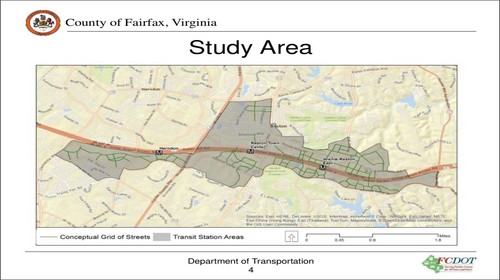
The Reston Transportation Study Area. Image from Fairfax County.
The study will also look at ways to improve four specific areas: Reston Parkway from Lawyers Road to Baron Cameron Avenue; Fairfax County Parkway at Spring Street; Fairfax County Parkway at Sunrise Valley Drive; and Rock Hill Bridge, which connects Loudoun County and Fairfax County over the Dulles Toll Road.
These areas are under consideration because they are important parts of Reston’s transportation network and are currently over capacity or will be after the redevelopment around the Metro stations occurs. The study will also look at how to make it easier to bike and walk in these areas.
The Hunter Mill Supervisor has appointed the Reston Network Analysis Advisory Group to help staff develop and test ways to make the street grids better.
In 2015, the Fairfax Department of Transportation presented a report that summarized existing conditions by looking at traffic counts from mid-2015. Among the key findings in the report:
- During evening commutes, the intersection of Wiehle and Sunset Hills rates an “F” for level of service
- The planned grid of streets will make pedestrian access and mobility near transit stations better
- The report also published baseline vehicle volume levels near current and future Silver Line stations
For future trips that come from more density around the coming Metro stations, the goal is to cut vehicle trips within a quarter mile of the stations by 45%.
Members of the public can learn about and comment on the project at a meeting on Monday, February 1 from 7-9 pm at Lake Anne Elementary School, which is at 11510 North Shore Drive in Reston. You can also contact project manager Kristin Calkins at Kristin.Calkins@fairfaxcounty.gov.