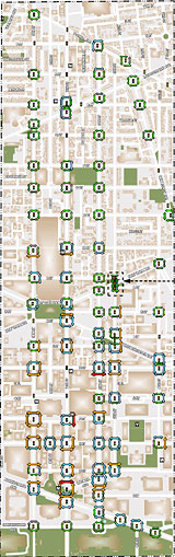
Here’s where a protected bikeway could go on the east side of downtown
People who want to ride a bike north-south along the east side of DC’s central business district and in Shaw could soon have a new protected bikeway to do it. A new study recommends four options, including 6th Street NW, 5th and 6th, or 9th.

The 15th Street protected bikeway. Photo by Elvert Barnes on Flickr.
The District Department of Transportation (DDOT) has been studying options for a bikeway to connect areas between Florida and Constitution Avenues. This bikeway would connect central DC neighborhoods, downtown, and the existing major east-west bikeways like the one on Pennsylvania Avenue.
This area has high levels of bicycling and many popular destinations but a distinct lack of quality bike facilities. Currently, 7th Street has the most bicycle traffic, but usage is pretty evenly spread out. 5th stands out because a large number of people ride south on 5th despite the road being one-way north.
DDOT planners studied an assortment of designs, considering every street between 4th and 9th. They first eliminated 4th and 8th because they were discontinuous streets. After a round of data gathering, where they looked at parking, parking utilization, auto and bicycle traffic, transit, potential pedestrian conflicts, cost, loading zones, events, and institutions along the route, they eliminated 7th Street because of heavy transit and pedestrian usage; they didn’t want the bikeway to become an auxiliary sidewalk.
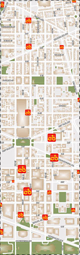
Data on transit ridership (left), pedestrian volume (center), and Capital Bikeshare usage (right) in the study area. Images from DDOT.
During this whole process, they have also been involved in a public outreach effort, meeting with institutions, businesses, churches, council staff, and other stakeholders. With data screening complete, there are four alternatives which they have made public and plan to discuss at an upcoming public meeting. After that, they will narrow the alternatives to three, which will get more intensive study and planning before choosing a preferred alternative sometime this winter.
Here are the alternatives:
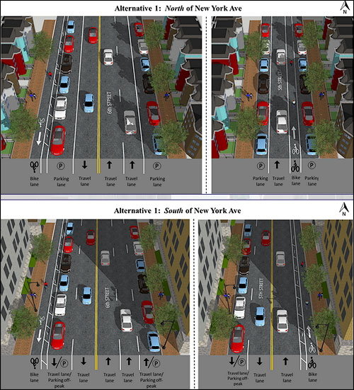
5th and 6th couplet: Alternative 1 would place a one-way northbound protected bikeway on the east side of 5th Street up to New York Avenue and a painted bike lane north of that. A one-way southbound bikeway would go on the west side of 6th.
This would remove a travel lane on 6th north of New York and a parking lane south of there. On 6th south of New York Avenue, the bikeway would be adjacent to a rush hour travel/off-peak parking lane converted from what is now a southbound travel lane. While DDOT considered using angled parking on 6th, that didn’t make it into the final design.
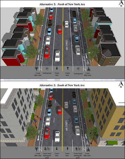
One-way on on each side of 6th: Alternative 2, would replace a travel lane in each direction on 6th Street with a one-way protected bikeway on each side. South of New York Avenue the bikeways would be adjacent to a rush hour travel/off-peak parking lane.
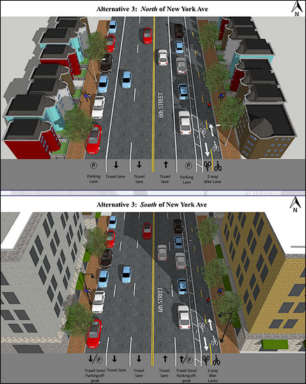
Bi-directional on 6th: Alternative 3 would remove a northbound travel lane north of New York Avenue and a parking lane south of New York and would convert a northbound travel lane to a rush hour travel/off-peak parking lane to make room for a bi-directional protected bikeway on the east side of 6th. This is similar to what exists on 15th Street (though the one on 15th is on the west side).
Bi-directional on 9th: Alternative 4 is like Alternative 3, but on 9th Street. A northbound travel lane north of Massachusetts Avenue and a parking lane south of Massachusetts Avenue would disappear, while a northbound travel lane would become an rush hour travel/off-peak parking lane. This would make room for a bi-directional protected bikeway on the east side of 9th. The southbound bike-bus lane would remain.

Bike planners are looking at numerous factors in deciding which to eliminate next. All the alternatives have similar expected travel times for cyclists, so that will not be a factor. But they will be considering turns across bike facilities, pedestrian intensity next to the bikeway, the amount of protection along the facility, and other safety factors.
As one example, the Verizon Center often shuts down a lane on the west side of 6th Street for loading for shows. That could be an obstacle for Alternative 2. There may be similar challenges in other spots for the other alternatives.
The planners will look at which designs affect buses the least, and how to deal with the unique parking needs of churches to accommodate their loading and unloading requirements, large event needs, funeral needs, etc.
Alternative 1 provides the least protection. DDOT has decided not to remove on-street parking in residential areas, which limits 5th street to painted bike lanes north of New York. Another consideration for 5th Street is that it has fewer stop lights, but more stop signs and some speed bumps.
In Alternative 4, 9th is one-way south of Massachusetts, so northbound cyclists would be going the opposite direction from car traffic, meaning it would suffer from the same light timing issues as 15th Street does. Timed lights on 15th mean people riding north hit more red lights than on a typical street.
DDOT has a website with all the designs which is accepting comments. The team is planning a public meeting soon, but haven’t settled on details. If a final design is chosen this winter, work could begin before the end of 2016.
Which design do do you think is best?