Petworth residents say changes to a dangerous traffic circle should go further
Many people in Petworth lament how dangerous it is to cross the street and get to Grant Circle, one of their neighborhood parks. DDOT has an initial plan for addressing the problem, but pedestrian advocates say the real way to make the circle safer is to make the streets narrower and add more crosswalks.

Photo of Grant Circle by Eric Fidler on Flickr.
Like a lot of circles in DC, Grant Circle has a design that’s invites people to use the interior space as a park but, more recently, has made moving traffic between its several intersections a major priority.
Drivers tend to speed through Grant Circle, partly because it has two wide lanes surrounding it that encourage passing. With drivers entering from the eight different intersections around the circle, and sometimes speeding to pass each other, it can be a harrowing place for people on foot or riding bikes.

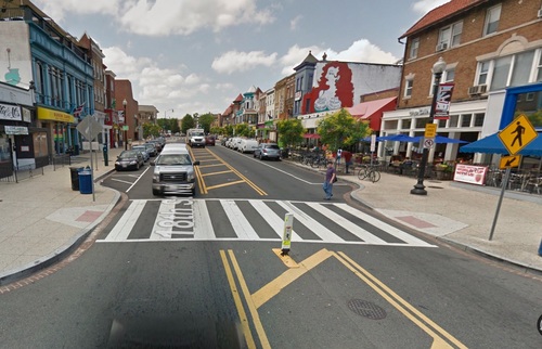
Streetview of Grant Circle today. Image from Google Maps
Every few months, a new thread starts up on the Petworth neighborhood listservs about near misses or actual crashes around Grant Circle like one last week, when someone drove their car into the circle.
“Grant Circle is an absolute mess for pedestrians,” wrote one resident recently. “When I drive, I often hesitate to stop for pedestrians because I know cars will zoom around me and make it much more dangerous for the people that are crossing. When I do stop I often go between both lanes to try to ensure the pedestrian safety which is obviously not the best thing to do.”
While well-intentioned, that second solution obviously isn’t a safe alternative to Grant Circle’s hazards.
“The design of the circle is so wide and big that instead of helping to slow down cars, it makes them to speed up,” added another. “If so many of us have already had nearly misses, some tragedy will end up happening.”
Plans to calm Grant Circle’s traffic have fallen short of a bigger vision
After hearing from community members and ANC commissioners, DDOT released initial plans to both add new striping to the streets around Grant Circle and to narrow their lanes. Both should calm traffic as it enters the circle.
DDOT’s immediate plans to add striping to Grant Circle to narrow lanes and calm traffic as it enters the circle. Image courtesy of DDOT.
This is a step in a process that started in 2009, when DDOT completed its Pedestrian Master Plan. The plan’s goals were to make it safe and comfortable to walk anywhere in the city, both through city-wide policy solutions and targeted changes to certain streets’ designs.
The Master Plan placed a heavy focus on L’Enfant’s radial avenues, which is where the majority of today’s crashes involving pedestrians happen. It plan designated “priority corridors” in each ward, which were places that saw a lot of pedestrians, had a dangerous design, and had a lot of crashes involving pedestrians as a “priority corridor.”
New Hampshire Avenue, including Grant Circle, is Ward 4’s priority corridor, and it was slated to get bumpouts along New Hampshire and a new design to calm traffic around the circle. These plans represent a more complete vision to calm traffic than the initial striping DDOT is proposing, though new ideas in traffic engineering could help even more.
Grant Circle’s two-lane design is needlessly dangerous
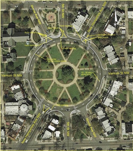
Every street intersecting Grant Circle is one lane in each direction, except for New Hampshire Avenue south of Grant Circle. There, New Hampshire has two lanes in each direction until it turns into Sherman Avenue, which has one lane in each direction.
If New Hampshire has one lane in each direction north of the circle and again a few blocks south, does it really need two lanes in the first place?
The two lane design means that parents with kids, dog owners with dogs, elderly people and those with disabilities, and anyone else trying to get to the park have to contend with serious traffic, which enters the circle from eight different points, to do so. And while relatively few cars use the passing lane, those that do tend to speed and pose an extra risk to people walking.

Grant Circle today. Image from Google Maps
Let’s consider some possibiltiies
All Walks DC, an organization I’m a part of, has a few thoughts for how Grant Circle could be made safer to walk and bike to and through.
When you look at Grant Circle’s interior paths, you can see where the original designer intended for people to be able to cross into and through the circle (though for some reason it leaves out paths to 5th Street NW). But out of the 12 places that those interior paths intersect Grant Circle, only 5 have crosswalks today. Some streets, such as Varnum on the East, don’t have any crosswalks at all, meaning that all the neighbors on that street have to walk a block south to use a marked crosswalk.
One simple fix would be to to add the crosswalks that are obviously missing.

DDOT’s 2009 plans for Grant Circle include a raised brick inner lane to calm traffic. Image from DDOT.
Narrowing Grant Circle to one lane would make crossing on foot much safer. DDOT’s 2009 plan includes a proposal to make the inner lane raised brick, which is a half step in this direction. But while this would discourage speeding and passing, it would likely be expensive, and there are probably better uses for that space.
For a lot less money, DDOT could bring down speeds and make Grant Circle more pedestrian and bike-friendly by allowing parking in the inner lane and building bumpouts at all the crosswalks.
Bumpout on 18th Street in Adams Morgan. Image from Google Maps.
DDOT could also car lanes by creating a protected bikeway, which the Move DC plan calls for, along the outside of the circle.
Finally, it’s worth considering using lanes to increase park space, which has happened in New York City. Extending Grant Circle outwards would be more complicated due to coordination with the National Park Service, but would add about a half acre to the area of the park.
Calming traffic around Grant Circle is an important part of kicking off DC’s Vision Zero efforts, as it would be an example of a community-supported project to make a street with known dangers safer for people walking. Several residents have already noted dangers around Grant Circle on DDOT’s Vision Zero map, which you can view and add to here.
If you live nearby and would like to sign a petition for a safer Grant Circle, click here.