DC has too few dedicated east-west bike pathways
While DC’s bicycling network has grown, there still aren’t a lot of crosstown connections. In fact, there are no protected east-west bicycle routes in the whole third of the District north of Florida Avenue. Cyclists need more of these, as well as north-south routes to form a grid of dedicated paths.
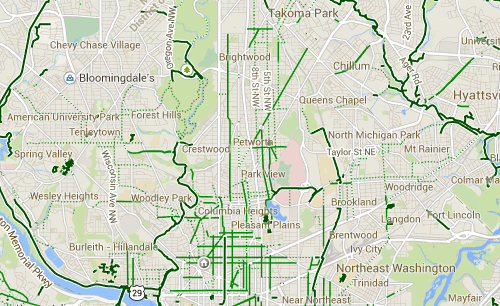
Bike lanes around a northern section of DC. Image from Google Maps.
Much of DC’s bicycle infrastructure, like trails, dedicated bikeways, and bike lanes concentrates in the downtown core, primarily south of Florida Avenue. DDOT’s official bicycle map, last updated in 2011, shows that outside of downtown, most bicycle facilities run north-south.
Unless they are willing to ride on six-lane, shoulder-
free roads with fast-moving traffic, cyclists have no way to traverse the northern part of Rock Creek Park, where only a freeway-like portion of Military Road crosses the park.
The same goes for Irving Street and Michigan Avenue, the only direct paths from Columbia Heights to Brookland across the vast acreage of McMillan Reservoir and Sand Filtration Site, the Washington Hospital Center, and the Armed Forces Retirement Home.
“East-west mobility for bicyclists in the northern neighborhoods of DC can be a significant challenge,” said Washington Area Bicyclist Association (WABA) Advocacy Coordinator Greg Billing. “Large campuses, parks, hospitals and cemeteries limit the available east-west connections. The MoveDC plan calls for high quality bicycle facilities from neighborhoods to downtown and better connections between the neighborhoods.”
That plan recommends some form of dedicated bikeway along Irving Street, as well as for a cycletrack on Military Road.
A route between Columbia Heights and Brookland would connect two vibrant neighborhoods and serve an area that will gain population as the McMillan site and part of the Armed Forces Retirement Home property redevelop.
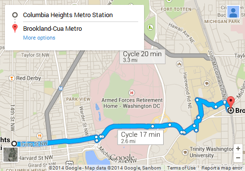
Google Maps’ bicycle directions from the Columbia Heights Metro to the Brookland-CUA Metro. Image from Google Maps.
Currently, both the DDOT map and Google Maps advise cyclists to use Irving Street between Brookland and Columbia Heights. However, between Park Place NW and the Catholic University campus, Irving Street is a busy six-lane near-freeway with no shoulder. Cyclists have to navigate among drivers merging on and off at the massive cloverleaf intersection with North Capitol Street.
However, the right-of-way through this section seems wide enough for DDOT to add a protected cycle track or trail. One possibility is a cycle track in a protected median down the middle of Irving Street, which would avoid dangerous crossings of the off-ramps at the Irving and North Capitol cloverleaf. Another is to have a trail parallel the existing sidewalk on the south side of Irving Street.

Google Maps street view of Irving Street between First and North Capitol Streets NW.
Worsening traffic congestion is a major concern at the McMillan site. The area has infrequent bus service and is far from a Metro station, but improving bicycle access could provide an important alternative to driving, reducing the traffic impact of new development.
Military Road NW across Rock Creek Park is a similar case. Tilden Street and Park Road to the south, and Wise Road, Beach Drive, and Kalmia Road to the north, are more bike-friendly ways to cross the park. But they’re far out of the way for neighborhoods on either side.
According to DDOT Bicycle Program Coordinator Mike Goodno, DDOT controls the road itself and a handful of feet on either side. The National Park Service would have to okay any further widening. DDOT has not yet studied whether there is room to add a cycletrack on Military within the right-of-way it controls.
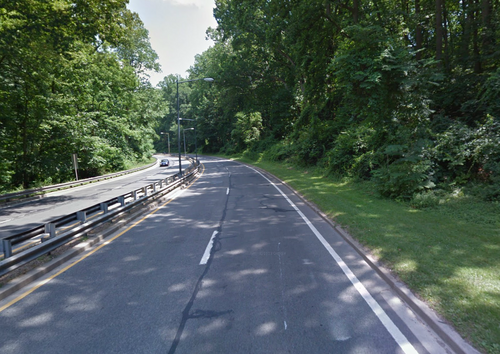
Google Maps Street View of Military Road NW through Rock Creek Park.
The only other connection through Rock Creek Park that is further along in the planning process is the Klingle Trail, which will connect the Rock Creek trail to Woodley Road NW. DDOT completed an Environmental Assessment in 2011.
As activity centers outside the downtown area grow and travel patterns become less centralized, we must enable cyclists and transit users to get across town as easily as drivers. A grid-like, interconnected network of bike routes would make that possible.