In 2050, the region will be a web, but how strong?
Regional leaders have released their Greater Washington 2050 report, “Region Forward,” a vision for the Washington region 40 years from now.
The report predicts an ongoing evolution of the region from a “hub and spoke” model to a “lattice” of interconnected “regional activity centers,” each with its own walkable, mixed-use core, with transit and roads within and between centers. The Coalition for Smarter Growth is holding a forum on the plan tomorrow evening.
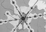
Grid, spoke, and web development patterns. Images from Greater Washington 2050.
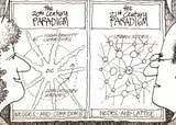
If the urban planning model of the 18th century was the grid and the 20th century the hub and spoke, the report’s authors say, the model of the 21st century is a web or lattice. Largely, this is a consequence of the politics of land use. In the 18th and 19th centuries, cities grew outward incrementally. The low-density housing adjacent to the downtown area became denser housing; the farms beyond that turned into low-density housing; and forests or meadows beyond that turned into farms.
But now, it’s just about impossible for an existing neighborhood to evolve into a denser one. Residents of row house neighborhoods fight high-rises; residents of detached house neighborhoods fight row houses. Even turning parking lots or strip malls right next to Metro stations is a big fight. The only development pattern that doesn’t generate political resistance is building more sprawl, and that’s not sustainable.
Therefore, regional leaders have decided it’s more realistic to essentially put new dense centers in less-developed outer areas where there’s more political support. This had the added benefit of giving each county some development; instead of telling Loudoun County that all the development should go in Fairfax or Arlington, they can have their own center. And hopefully, they’ll avoid just filling up the rest of the county with sprawl.
It’s a reasonable plan, if not the ideal development pattern, and the plan lays out a series of goals necessary to bring it about. Build transit in and among the nodes. Provide a diverse range of housing types and affordability levels. Ensure energy efficiency and good stormwater management in new development. Ensure good education and job training, access to health care and safe communities.
The challenge is for the region’s many governments to actually put their money where their mouth is. A stated commitment to dense centers and transit is good, but is a hollow promise if leaders then just go and approve new subdivisions in areas designated rural, as Prince George’s recently did, or decide to build auto interchanges instead of transit access at a growing place like the Medical Center Metro, as the Montgomery executive did. The COG map of planned roadway improvements somewhat resembles the activity center map, but has plenty of facilities that don’t connect or strengthen activity centers.

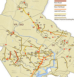
Left: Greater Washingon 2050 activity centers. Right: TPB planned highway projects.
It’s also important to build fewer, larger centers instead of more, smaller ones. Montgomery’s set of centers is not bad: They’re almost all along the existing Metro lines, the I-270/Corridor Cities Transitway corridor, and near I-95. Prince George’s has grouped their centers into a smaller part of the county for the most part. But Northern Virginia’s centers are much more scattershot, and larger in area while in many cases being lower in density.
A “net” is fine, but a bigger net is much weaker than a smaller net. It’s harder to connect a very large number of smaller activity centers across a wide area. To support walkable development and transit, the bigger the better, to build critical mass for transit and help more of the residents live near their jobs. Likewise, if the “center” is really several square miles of low- and moderate-density development without much of a center, it’s not really walkable and not really transit-oriented even if there’s a Metro station in the middle with a couple of tall buildings.
Too many centers, and we just get a regional version of the Gaithersburg West Master Plan, which defines a large number of “transit-oriented” nodes that require winding transit lines to reach, none of which is really big enough to be much of anything on its own, and which are too far apart to interact. The only way to make dense centers not create traffic is for most people to be able to live near their jobs or near a small number of transit lines to those jobs. That worked best in the 18th century model where there was just a single node. Get to 50 activity center, and it becomes tougher.
There’s no way to avoid becoming a “net,” given the politics of infill and regional jurisdictions’ appetite for getting their piece of the growth pie. But jurisdictions can make the choice to focus on fewer, larger activity centers. Fairfax should put most of its growth in Tysons and the Route 1 area. Loudoun should put it around Dulles. Prince George’s needs to pick where they want it instead of wherever a developer has some land they want to build on. Then, each jurisdiction should take the plunge, as Arlington did, and really let its centers become small cities in their own right, not just little bundles of office buildings with some housing.
Just getting regional leaders to agree to focus on activity centers at all would be a big start. But it’s easier to wimp out and scale back each plan, as Fairfax is doing with Tysons, and just kick some of the development out to the next new activity center. We need to focus on activity centers, and then push for fewer, more walkable, and better activity centers.
Some important regional leaders will be at tomorrow’s forum. Come and voice your thoughts. It’s at 6 pm at NCPC, 401 9th St NW, 5th Floor.